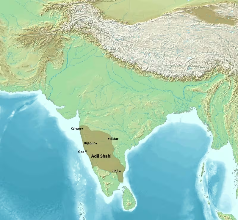
Sultanate of Bijapur at Its Territorial Peak, c. 1636–1656
Introduction
From the Arabian Sea to the Bay of Bengal, the Sultanate of Bijapur reached its widest territorial horizon during the reign of Muhammad Adil Shah. The map for c. 1636–1656 captures the kingdom after its treaty with the Mughal Empire and before the succession of crises that brought the Adil Shahi dynasty to an end. Its territory was not a simple, uniformly administered block: it combined an established northern Deccan core, recently incorporated areas, southern conquests, and zones where authority was expressed through campaigns, tribute, or political pressure.
Bijapur began as a Bahmani provincial government. Yusuf Adil Shah, appointed governor of the province of Bijapur, used the decline of Bahmani power to establish a de facto independent state in 1490. Independence became formal with the collapse of the Bahmani political order in 1518. The Adil Shahi rulers then competed with the other Deccan sultanates, Vijayanagara and its successor Nayaka states, the Portuguese in Goa, the Mughals, and eventually the Marathas.
The selected map period centres on Muhammad Adil Shah, who succeeded Ibrahim Adil Shah II in 1627. The 1636 agreement with the Mughals brought a period of relative peace in the north and allowed Bijapur to concentrate on southern expansion. By the middle of Muhammad’s reign, the sultanate had reached its territorial peak. His death in 1656, followed by intensified Mughal and Maratha pressure, marked the beginning of a rapid political decline that ended with Aurangzeb’s conquest of Bijapur on 12 September 1686.
Historical Context
From Bahmani province to independent sultanate
Bijapur’s political identity emerged from the fragmentation of the Bahmani Kingdom. Before 1490, Bijapur was a taraf, or province, of the Bahmani state. Yusuf Adil Shah rose within the Bahmani administration and became governor of the province. He then established an independent authority at Bijapur in 1490, initially taking advantage of the weakening of the Bahmani political structure.
Yusuf’s ancestry is debated. One tradition associated him with Georgia; other accounts describe him as Persian, Turkmen, or connected with the Aq Qoyunlu Turks. The contemporary historian Firishta presented a claim that Yusuf was a son of the Ottoman sultan Murad II, but modern historians dispute this identification. The uncertainty is significant because later dynastic traditions often connected rulers to prestigious foreign lineages, while the political foundation of Bijapur lay in the changing military and administrative society of the Deccan.
Yusuf expanded his authority beyond the original province. He conquered and annexed the Bahmani taraf of Gulbarga and introduced Shia Islam as the official religion of his territorial holdings in 1503. This policy was not permanently fixed. Under pressure from neighbouring states, he temporarily revoked the change and later reinstated it. The episode illustrates the close connection between religious affiliation, dynastic identity, and the strategic politics of the Deccan.
The western coast and the Portuguese challenge
Goa was the most important western coastal point in Bijapur’s early territorial history. A Portuguese expedition led by Afonso de Albuquerque captured the port in 1510. Yusuf Adil Shah retook it two months later, but the Portuguese conquered it again in November of the same year. Yusuf died in 1510 between these two confrontations, leaving a young son, Ismail Adil Shah, to succeed him.
The struggle over Goa demonstrated the limits of Bijapur’s coastal position. For much of its history the sultanate was bounded on the west by the Portuguese state of Goa. The relationship was not simply a fixed border dispute: it also involved pressure on ports and concern that Portuguese control of maritime trade could damage Bijapuri prosperity. Under Ibrahim Adil Shah I, Bijapur ceded two ports because of the fear that trade through Goa might be cut off.
The available record does not provide a complete list of ports, shipping routes, customs stations, or naval forces. The map therefore treats Goa as a major political and maritime reference point rather than attempting to reconstruct an undocumented Bijapuri roadstead or commercial network.
Conflict with Vijayanagara
The eastern and southern shape of Bijapur was repeatedly determined by its wars with the Vijayanagara Empire. The Raichur Doab was especially important. In 1520, Krishnadevaraya of Vijayanagara besieged the Bijapuri fort of Raichur. Ismail Adil Shah attempted to end the siege but was defeated in a battle in which Bijapur’s artillery initially offered an advantage before a surprise Vijayanagara counter-attack scattered much of the Bijapuri force. Krishnadevaraya captured Raichur and later occupied Bijapur for an extended period.
After Krishnadevaraya’s death, Ismail recovered Raichur and Mudgal. The region remained contested under later rulers. Ibrahim Adil Shah I invaded Vijayanagara territory and pillaged cities, but he did not retain territory from that campaign in the long term. Under Ali Adil Shah I, Bijapur joined Ahmednagar, Golconda, and Bidar against Vijayanagara. Their victory at the Battle of Talikota in 1565 transformed the political geography of the Deccan.
Rama Raya, the de facto ruler of Vijayanagara, was captured and beheaded. Vijayanagara and nearby cities were sacked and looted for several months. The Raichur Doab and surrounding areas were returned to Bijapur. The Vijayanagara military was severely weakened, and its political authority became a shell of its former strength. This victory allowed Ali Adil Shah I to turn Bijapur into a more centralised and territorially ambitious state.
Ali’s later campaigns extended into the southern peninsula. He annexed Adoni and much of the Carnatic, and began a broader campaign in the Karnatak. The historical record describes the destruction of two to three hundred Hindu temples during these operations and their replacement by Shia buildings, although the full geography and chronology of these changes are not fixed in the map record. These campaigns created the southern foundation for the later territorial peak.
Consolidation in the late sixteenth and early seventeenth centuries
Ibrahim Adil Shah II succeeded Ali Adil Shah I in 1580 as a nine-year-old. His reign was associated with prosperity, courtly patronage, Sufi activity, and the growth of Bijapur as a wealthy cultural centre. He founded Nauraspur in 1599 as a planned centre of learning and art three kilometres west of Bijapur. The project was never completed and was destroyed in 1624 by the forces of Malik Ambar.
Ibrahim II also faced the changing balance of power in the Deccan. The Mughal Empire expanded southward, while Ahmednagar continued to resist through Malik Ambar after the Mughal capture of Ahmednagar in 1600. Bijapur and Ahmednagar had previously fought over territory, but they also formed alliances when Mughal expansion threatened both states. In 1597, Bijapur, Ahmednagar, and Golconda attempted to deter further Mughal advances. Their alliance was defeated despite a numerical advantage.
Bijapur conquered the neighbouring Bidar Sultanate in 1619. The arrangement was preceded by an agreement between Bijapur and Ahmednagar dividing their spheres of influence. Ahmednagar was permitted to pursue Berar, while the Adil Shahis could expand south into the weakening Vijayanagara sphere without Nizam Shahi interference. Bidar lay outside those agreed spheres. Malik Ambar invaded Bijapur, reached the capital with little resistance, and then withdrew. The following year, Bijapur achieved control over Bidar.
Muhammad Adil Shah and the territorial peak
Muhammad Adil Shah inherited the throne in 1627. His reign began in a difficult political environment, but the 1636 treaty with the Mughal Empire created a period of relative northern stability. Bijapur agreed to pay tribute and acknowledge Mughal authority. In return, the recently conquered territories of Ahmednagar were divided between the Mughals and Bijapur.
This settlement allowed the Adil Shahi state to intensify its southern campaigns. The sultanate expanded through the Karnatak and Carnatic, reaching areas as far south as Tanjore. The map’s broadest extent should therefore be read as a combination of direct possession, military occupation, and nominal authority rather than as a modern-style boundary line. Muhammad Adil Shah’s kingdom reached its territorial peak during this period, with an east-west horizon described as extending from the Arabian Sea to the Bay of Bengal.
The expansion carried serious internal costs. Relations between the sultan and nobles became strained, and the prosperity of the state was damaged by disputes involving nobles and landholders. The revolt of Shivaji, whose father had served as a Maratha commander for Muhammad, created a new political challenge in the northern Deccan. Muhammad died in 1656 after a decade-long illness, leaving a troubled kingdom to Ali Adil Shah II.
Territorial Extent and Boundaries
Northern frontier
Bijapur’s northern boundary was relatively stable compared with its southern frontier. It lay across contemporary southern Maharashtra and northern Karnataka. This zone connected the sultanate to the Mughal sphere after the 1636 treaty and to the territories associated with the former Ahmednagar Sultanate.
The northern frontier was nevertheless militarily exposed. Mughal intervention began before Muhammad’s reign: in 1631, Shah Jahan’s forces reached and besieged Bijapur but failed to capture it. The 1636 agreement reduced immediate Mughal pressure but did not make Bijapur independent of Mughal influence. The Adil Shahis acknowledged Mughal authority and paid tribute, meaning that the northern edge of the kingdom was also a zone of imperial suzerainty.
Southern frontier
The southern frontier changed most dramatically. Initially, Bijapur was bounded by the Vijayanagara Empire and later by the Nayaka dynasties that inherited authority in parts of the south. After Talikota in 1565, the weakening of Vijayanagara made possible a sequence of Bijapuri campaigns.
Ali Adil Shah I conquered Adoni and much of the Carnatic and continued operations in the Karnatak. Later campaigns under Ali Adil Shah II captured Thanjavur and other cities from the Nayakas between 1659 and 1663. Those conquests occurred after the selected peak period begins, but they belong to the same broader process of southern expansion that shaped the map of Bijapur.
The record describes Bijapur’s authority reaching as far south as Tanjore. It does not establish a continuous administrative frontier across every part of southern India. Southern territories should therefore be shown in graduated categories: established Bijapuri holdings, recently conquered regions, and areas under nominal or campaign-based authority.
Western frontier
The western frontier faced the Portuguese state of Goa. Portuguese possession of Goa began in 1510 after repeated fighting with Yusuf Adil Shah. Goa remained a persistent feature of Bijapur’s western political geography. The Portuguese presence affected both security and commerce, particularly because Bijapur’s rulers feared that trade through Goa could be restricted.
The western boundary should not be interpreted as a complete division between an inland state and a maritime colony. Bijapur’s history included access to ports, disputes over coastal settlements, and diplomatic or military pressure connected with Portuguese expansion. However, the available record does not specify the full coastal sequence of Bijapuri ports or the exact line separating Portuguese and Adil Shahi authority.
Eastern frontier
The eastern side of the sultanate bordered Golconda. Relations with Golconda alternated between conflict and alliance. The two states were among the Deccan sultanates, a group of five successor states that emerged from the fragmentation of Bahmani power. Their cooperation was most visible in the alliance against Vijayanagara in 1565 and in efforts to resist Mughal expansion.
The eastern zone also opened toward the southern campaigns. Bijapuri forces operating in the Karnatak and Carnatic extended the practical reach of the state well beyond its older northern Deccan core. The phrase “as far as the Bay of Bengal” conveys the maximum eastward horizon of the territorial peak, but it should not be mistaken for evidence that every intervening district was governed in the same manner.
Natural geography and contested regions
The principal physical setting was the Deccan plateau, with the Raichur Doab forming a major strategic region between the Krishna and Tungabhadra river systems. Raichur and Mudgal were repeatedly contested because control of the doab affected access between the northern Deccan and the territories of Vijayanagara.
The map also includes the western coastal region and the southern plateaus and plains of the Karnatak and Carnatic. The available historical account names no complete system of mountain passes or riverine boundaries. Natural features are therefore used as geographical orientation rather than as asserted legal borders.
The most contested spaces were Raichur, Mudgal, Bidar, Gulbarga, Kalyani, Solapur, and the southern territories formerly associated with Vijayanagara or the Nayakas. Control of these places changed through siege, treaty, alliance, and conquest.
Administrative Structure
Bijapur was ruled by the Adil Shahi dynasty, with nine sultans governing between 1490 and 1686. The sultanate developed from a Bahmani provincial administration, but its later political structure was shaped by the need to manage a large and expanding military state.
The capital, Bijapur, remained in place throughout the sultanate’s existence. It was not replaced when the state expanded southward. This continuity made Bijapur the central location for royal authority, court culture, architectural patronage, and high-level administration. Ibrahim Adil Shah I fortified the city with a citadel and walls and supported the construction of a congregational mosque. Ali Adil Shah I further fortified Bijapur after the victory over Vijayanagara, helping centralise authority and encourage the growth of a skilled urban population.
The territorial record indicates the existence of provinces and former Bahmani tarafs, including Bijapur and Gulbarga. It does not provide a complete list of all provincial divisions, the hierarchy of officials, or the exact fiscal arrangements of each conquered region. Southern campaigns likely required different forms of control from the older northern core, but the surviving account does not allow every area to be classified precisely as a directly administered province, dependent state, or military occupation.
The distinction between central administration and local power was particularly important during the later period. Nobles and landholders possessed enough influence to challenge the sultanate’s stability. Under Muhammad Adil Shah, strained relations with these groups contributed to the decline of prosperity. Under Sikandar Adil Shah, factional conflict and regency politics became central problems.
The history of Bidar illustrates how territorial control could be achieved in stages. Bijapur’s agreement with Ahmednagar preceded the 1619 conquest, but the sultanate’s practical control over Bidar had developed earlier, as early as 1580. The distinction between first intervention, political influence, and formal conquest is therefore essential when reading the map.
Infrastructure and Communications
Bijapur’s fortifications were a central part of its territorial infrastructure. The capital possessed a citadel and city walls, while Raichur, Mudgal, Bidar, Kalyani, Solapur, and other places functioned as fortified or strategically important locations during successive wars. Forts controlled routes, protected political centres, and served as objectives in campaigns.
The historical record describes sieges at Raichur, Ahmednagar, Kalyani, Solapur, and Bijapur itself. It also records the capture and exchange of forts. These references suggest a political landscape in which communication and control depended heavily on fortified places, military movement, and the ability to sustain sieges.
No comprehensive road network is described. There is likewise no securely documented postal system or standardised communication route in the material available for this map. It would be misleading to draw a detailed network of roads or relay stations without additional evidence. The map instead uses campaign theatres and fortified centres to indicate the principal corridors of political and military communication.
Maritime capability is also difficult to reconstruct in detail. Bijapur’s western position brought it into direct conflict with the Portuguese, and the sultanate controlled or contested ports. Yet the account does not list a standing navy, shipping tonnage, maritime trade routes, or naval bases. Goa is therefore shown as a western strategic and commercial reference point, not as evidence for a fully documented Bijapuri maritime system.
Firearms played a role in Deccan warfare. At Raichur in 1520, Bijapur’s artillery initially gave Ismail Adil Shah an advantage before the Vijayanagara counter-attack. The battle demonstrates the importance of gunpowder weapons in controlling fortified positions, but the available record does not provide a complete inventory of artillery, cavalry, infantry, or logistical arrangements for the mid-seventeenth-century state.
Economic Geography
Bijapur’s economy was connected to both the inland Deccan and the western coast. Control of the interior provided access to cities, fortresses, agricultural territories, and routes toward the south. The western seaboard connected the sultanate to maritime commerce, while Portuguese control of Goa threatened to restrict access and damage trade.
The kingdom’s economic geography expanded with its territorial conquests. Recovery of the Raichur Doab after Talikota brought a strategically and agriculturally significant region back under Bijapuri authority. The annexation of Bidar in 1619 added a major northern Deccan centre. Southern campaigns under Ali Adil Shah I and later rulers brought parts of the Karnatak and Carnatic into the state’s political and economic orbit.
The record does not identify specific commodities, crop zones, customs duties, market regulations, or annual revenues. It does, however, associate Ibrahim Adil Shah II’s reign with prosperity and describe Bijapur as one of India’s most prosperous cities. Accounts from the period suggested that the wealth of ordinary people and the urban population had increased. Population estimates for Bijapur in the latter half of Ibrahim II’s reign reached as high as one million, although this is an estimate rather than a census and belongs to an earlier phase than the map’s central date.
The city’s wealth was expressed through architecture and court culture. Bijapur’s rulers commissioned palaces, mosques, mausoleums, and other structures. The city also attracted Sufis, poets, musicians, artists, administrators, and skilled workers. Nauraspur was founded as a planned centre of learning and art, although it was never completed and was destroyed in 1624.
The capital’s prosperity depended on the wider political environment. Military expansion could increase access to land and revenue, but constant warfare also imposed costs. Strife with the Marathas, pressure from the Mughals, and disputes among nobles and landholders weakened the state. The decline of prosperity during Muhammad Adil Shah’s reign shows that territorial size did not automatically produce political or economic stability.
Cultural and Religious Geography
The Adil Shahi state was culturally connected to the wider Persianate world while developing a strongly local Deccani character. Yusuf Adil Shah’s association with Shia Islam, Ibrahim Adil Shah I’s adoption of Sunni Islam, and Ali Adil Shah I’s restoration of Shia Islam demonstrate that official religious affiliation changed across the dynasty’s history.
Under Ibrahim Adil Shah II, religious and cultural syncretism reached a high point. Sufism flourished, and Bijapur attracted adherents and visitors because of the ruler’s reputation as a musician and poet. The court supported writing in the Deccani language, and Bijapur became a centre of early literary development in Deccani Urdu.
Ibrahim II wrote the Kitab-i Nauras, a work of Deccani musical poetry. He patronised poets and supported a courtly culture that crossed linguistic and artistic boundaries. His poet laureate, the Persian writer Muhammad Zuhuri, composed the Saqinama. Firishta, who entered Ibrahim’s service in 1604, wrote the Tarikh-i Firishta, a major history of the medieval Deccan. Nusrati later wrote the romantic poem Gulshan-i ‘Ishq and a narrative of the conquests of Ali Adil Shah II.
The architectural geography of Bijapur is especially prominent. Adil Shahi architecture combined Indo-Islamic forms with Deccani, Persianate, and local elements. Its features included large domes, dargahs, complex turrets, geometric designs, Arabic or Persian calligraphy, and decorated friezes. The tradition included the expansion of two dargahs at Gulbarga under Yusuf Adil Shah.
The Jami Masjid of Bijapur was commissioned under Ali Adil Shah I in 1576 and was described as among the most imposing structures in the Deccan. Under Ibrahim II, architectural patronage became more intricate and detailed. The Malika Jahan Begum mosque, built in 1586, reflected Hindu–Muslim syncretism in its artistic language.
The Ibrahim Rauza, associated with Ibrahim Adil Shah II, included a mosque and a mausoleum for the ruler’s family and was completed in 1626. Muhammad Adil Shah’s most famous project was the Gol Gumbaz, his mausoleum and one of Bijapur’s greatest monuments. Its enormous dome and arched recesses made it a defining feature of the capital’s skyline. The Bara Kaman, begun as the mausoleum of Ali Adil Shah II, remained unfinished when construction halted after his death in 1672.
Religious geography was not limited to royal monuments. Sufi shrines and dargahs formed important centres of devotion, while the southern military campaigns altered the religious landscape through the destruction and replacement of temples in some conquered areas. These changes were uneven and tied to specific campaigns; they should not be represented as a uniform transformation across the entire sultanate.
Military Geography
Bijapur’s military geography was defined by forts, doabs, contested borderlands, and access routes into the territories of neighbouring powers. Raichur was the clearest example. Its fort and surrounding doab changed hands during conflicts with Vijayanagara and remained central to the strategic balance of the northern Deccan.
The 1520 siege of Raichur showed the importance of artillery, fortifications, and battlefield manoeuvre. Ismail Adil Shah’s initial advantage did not prevent defeat. Later, after Krishnadevaraya’s death, Bijapur recovered Raichur and Mudgal. The settlement of this frontier remained temporary until the larger coalition victory at Talikota in 1565.
Talikota transformed the military map. Bijapur, Ahmednagar, Golconda, and Bidar defeated Vijayanagara, and the Raichur Doab returned to Bijapur. The destruction of Vijayanagara’s military power opened the route for later campaigns into the Karnatak and Carnatic. Bijapuri armies subsequently captured Adoni and other southern locations and extended authority toward Tanjore.
The northern frontier required a different strategy. Bijapur faced Ahmednagar before the latter’s absorption into the Mughal Empire, and then faced direct Mughal campaigns. Shah Jahan’s forces besieged Bijapur in 1631 but withdrew without success. The 1636 treaty temporarily reduced the danger by acknowledging Mughal suzerainty. Yet the arrangement also placed Bijapur within a hierarchy dominated by the Mughal Empire.
Bidar was both a political centre and a military objective. Bijapur’s expansion into Bidar followed agreements concerning spheres of influence, conflict with Malik Ambar, and the gradual consolidation of control. The city became part of the Bijapuri state in 1619, strengthening the northern Deccan position.
The Maratha challenge developed during the later years of Muhammad Adil Shah’s reign. Shivaji’s revolt damaged the kingdom and later produced an independent Maratha kingdom. In 1659, Bijapuri general Afzal Khan was sent to subdue Shivaji but was killed in a confrontation at Pratapgarh, after which Shivaji captured the fort. This event symbolised the weakening of Bijapur’s control over its northern and western territories.
The military system’s precise organisation is not detailed in the available account. The record refers to sultans, nobles, governors, generals, artillery, alliances, sieges, and regional commanders, but it does not provide reliable army totals or a complete structure of cavalry and infantry divisions. The map therefore represents military geography through campaigns and strongholds rather than unsupported troop estimates.
Political Geography
Bijapur belonged to the political world of the Deccan sultanates. Its principal rivals and partners included Ahmednagar, Golconda, and Bidar. These states could fight one another over forts and provinces, yet they also formed coalitions when Vijayanagara or the Mughals became the more immediate threat.
Relations with Ahmednagar were particularly fluid. Ahmednagar invaded Bijapur several times during Ibrahim Adil Shah I’s reign and seized territory in the north. Bijapur and Ahmednagar also disputed Solapur and Kalyani. Under Ali Adil Shah I, military conflict alternated with negotiation. In 1561, Hussain Nizam Shah submitted to Rama Raya and returned Kalyani to Ali Adil Shah. In 1563, Ahmednagar again attempted to regain Kalyani, but the conflict ended without a permanent reversal of Bijapuri control.
The alliance against Vijayanagara in 1565 was a major political turning point. Previous conflicts did not prevent the sultanates from coordinating militarily. The victory enabled Bijapur to reclaim the Raichur Doab and expand southward. The political consequences extended beyond the battlefield because Vijayanagara’s weakened condition left its successor Nayaka dynasties exposed to Bijapuri campaigns.
Golconda was both a neighbour and an ally. It participated in the coalition against Vijayanagara and in later efforts to restrain Mughal expansion. Its position on the eastern side of Bijapur made relations with it essential to the balance of the Deccan.
The Mughal relationship changed from resistance to formal subordination. Agreements and treaties imposed Mughal suzerainty in stages. In 1636, Bijapur recognised Mughal authority and agreed to pay tribute. This did not immediately destroy the sultanate; instead, it provided a period in which Bijapur could expand southward. The arrangement nevertheless weakened the state’s independence and made future Mughal intervention easier.
The Portuguese represented a different kind of neighbour. Their control of Goa created pressure along the western coast and affected Bijapur’s commercial security. The Adil Shahi rulers also pursued diplomatic relations with the Mughals, Ottomans, and Safavids. These connections placed Bijapur within a wider Islamic diplomatic world while its immediate political struggles remained rooted in the Deccan and southern India.
Shivaji introduced a new political geography. His revolt began within the territories and military networks associated with Bijapur and developed into an independent Maratha kingdom. By 1674, the Maratha state had been founded and later became the Maratha Confederacy. It acquired de facto control over much of the Adil Shahis’ original Deccan territory and reversed many southern Bijapuri gains after Shivaji’s death in 1680.
Legacy and Decline
The territorial configuration represented here lasted only briefly as a stable political arrangement. The 1636 Mughal settlement enabled Bijapur’s maximum expansion, but the kingdom’s internal cohesion was already under pressure. Muhammad Adil Shah’s illness, strained relations with nobles and landholders, Maratha resistance, and Mughal supremacy all limited the durability of the peak.
Ali Adil Shah II inherited the kingdom in 1656. Mughal forces invaded in 1657 under Aurangzeb, capturing Bidar and other forts and reaching Bijapur before withdrawing. Much of the occupied territory, including Bidar, was later annexed. The Marathas continued raids and rebellions, while southern campaigns temporarily expanded the kingdom into the Carnatic.
Sikandar Adil Shah, the last ruler, came to the throne as a child and governed during fourteen troubled years. Regency disputes, factional conflict, civil war, and unrest weakened the state. Shivaji’s Maratha kingdom reversed much of Bijapur’s earlier southern expansion and continued to challenge the remaining Muslim states of the Deccan.
In April 1685, Aurangzeb’s Mughal forces began the final siege of Bijapur. On 12 September 1686, the sultanate ended. Its capital and surrounding territory were annexed into a Mughal subah, and Sikandar Adil Shah was sent into Mughal captivity.
Bijapur’s legacy survives most visibly in its urban architecture, literary traditions, Sufi institutions, and role in the history of the Deccan. The Gol Gumbaz, Ibrahim Rauza, Jami Masjid, city walls, citadel, and other monuments preserve the ambition of the Adil Shahi court. The dynasty also helped shape the cultural development of Deccani literature and music.
The map’s greatest value lies in showing the difference between a kingdom’s maximum reach and a permanently consolidated empire. Bijapur’s power grew through provincial inheritance, fortified centres, alliances, military victories, southern campaigns, and negotiated relations with larger powers. Its borders moved repeatedly, especially around Raichur, Bidar, Kalyani, Solapur, Goa, and the Carnatic. By the mid-seventeenth century, the sultanate had achieved an extraordinary territorial span, but the same expansion exposed it to the administrative, military, and political pressures that ultimately brought the Adil Shahi state to an end.