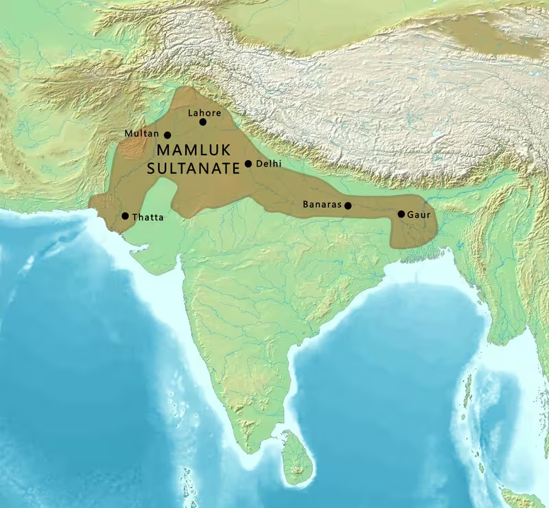
Mamluk Sultanate in India, 1206–1290
Introduction
The political centre of the Mamluk Sultanate moved decisively from Lahore to Delhi under Shams-ud-din Iltutmish, transforming a collection of former Ghurid territories into a more durable Delhi-based sultanate. This map follows that transition from the accession of Qutb ud-Din Aibak in 1206 to the deposition of the last Mamluk ruler in 1290.
The Mamluk dynasty, also called the Slave dynasty, was not a single uninterrupted family line. The name covers three successive ruling groups: the Qutbi dynasty from 1206 to 1211, the first Ilbari or Shamsi dynasty from 1211 to 1266, and the second Ilbari dynasty from 1266 to 1290. Their authority extended unevenly across the northern territories inherited from the Ghurid Empire. Delhi, Lahore, Multan, Ghazni, Bengal, and Badaun appear in the political geography of this period, but the surviving historical record does not establish a fixed boundary for every year.
Historical Context
Before 1206, Qutb ud-Din Aibak served as a Ghurid administrator. Between 1192 and 1206, he led campaigns into the Gangetic plain and established control over some newly acquired areas. When Muhammad of Ghor was assassinated in 1206 without a male heir, his empire fragmented among former Mamluk generals. Taj-ud-Din Yildoz ruled Ghazni, Muhammad bin Bakhtiyar Khilji held Bengal, Nasir-ud-Din Qabacha governed Multan, and Aibak took control of Delhi.
Aibak’s sultanate was brief. He initially made Lahore his capital and attempted to consolidate his authority over northern India. He temporarily suppressed the challenges posed by Qabacha of Multan and Yildoz of Ghazni. His death in 1210, caused by injuries sustained while playing polo in Lahore, brought Aram Shah to the throne. Aram Shah ruled for only a year before an elite group of forty nobles, known as the Chihalgani, invited Iltutmish, the governor of Badaun, to replace him.
Iltutmish defeated Aram Shah near Delhi in 1211 and became the principal architect of the early Delhi Sultanate. He shifted the capital from Lahore to Delhi, defeated rival claimants in Multan and Ghazni, and later recovered territories lost during the period of political instability. Bengal, previously controlled by the Khalji successors of Bakhtiyar Khilji, was incorporated into the Delhi Sultanate in 1227.
After Iltutmish’s death in 1236, the sultanate experienced rapid changes of ruler. Rukn-ud-din Feroze held power for seven months before being killed with his mother, Shah Turkan. Razia al-Din then ruled from 1236 to 1240. She managed the state effectively at first, but opposition from powerful nobles and clergy weakened her position. After her defeat, her half-brother Muiz-ud-din Bahram became sultan. He was overthrown in 1242 amid conflicts among the Chihalgani and during a Mongol attack on Punjab that included the sack of Lahore.
Ala-ud-din Masud ruled from 1242 to 1246, but the chiefs increasingly controlled the government. Nasiruddin Mahmud then became sultan, while his deputy, Ghiyas-ud-din Balban, handled much of the state’s administration. Balban became sultan in 1266 and ruled until 1287. His reign restored central authority, weakened the Chihalgani, and confronted both rebellious nobles and Mongol incursions.
Territorial Extent and Boundaries
The map should be read as a representation of political influence and changing control rather than a modern boundary survey. The Mamluk Sultanate’s core lay in northern India, especially around Delhi and the upper Gangetic plain. Lahore formed an early centre under Aibak, while Delhi became the principal capital under Iltutmish. Badaun was important because Iltutmish governed it before becoming sultan.
The north-western frontier connected the Delhi Sultanate with the political zones of Multan and Ghazni. These were not consistently subordinate territories. Nasir-ud-Din Qabacha of Multan and Taj-ud-Din Yildoz of Ghazni each asserted authority and contested Delhi’s position. Their rivalry demonstrates that the early sultanate’s western and north-western limits were politically unstable.
To the east, Bengal entered the Delhi Sultanate in 1227 after Iltutmish recovered it from the successors of Bakhtiyar Khilji. The record identifies Bengal as a major regional possession, but does not provide a precise line separating directly administered land from areas governed by local or semi-autonomous authorities.
The north was shaped by the approach of Mongol power. In 1221, Jalal-ud-din Mangabarni, the last Khwarazmshah, was defeated by Genghis Khan at the Battle of the Indus. Iltutmish avoided exposing India to the full force of Genghis Khan and his successors, while later rulers faced repeated Mongol pressure in Punjab and along the north-western approaches.
No securely fixed southern boundary is established in the historical account. The map therefore emphasizes the northern political heartland, the Gangetic expansion, Bengal, and the frontier zones toward Multan and Ghazni rather than presenting the sultanate as a uniformly controlled subcontinental empire.
Administrative Structure
The Mamluk state was governed through a combination of royal authority, provincial administration, military commanders, and powerful nobles. Aibak’s early rule involved consolidating authority over Delhi and the territories acquired during his Ghurid service. Iltutmish strengthened the central government after defeating rival claimants and moving the capital to Delhi.
The Chihalgani, or “the Forty,” was an elite group of nobles whose influence became especially visible after Iltutmish’s death. They helped remove Aram Shah, participated in the political struggles surrounding Razia, and controlled or influenced several short-lived sultans. Their power declined under Balban, who broke up the group and demanded loyalty to the crown.
Provincial authority was not uniform. Bengal, Multan, Ghazni, Lahore, and Badaun appear as distinct centres in the political record, but their precise administrative status changed over time. Some were governed by officials or commanders connected with Delhi; others were controlled by rivals who asserted independent authority. The map distinguishes these locations without assuming that each remained continuously under direct central rule.
Infrastructure and Communications
The best-attested infrastructure of the Mamluk period consists of monuments, reservoirs, stepwells, and religious buildings rather than a documented empire-wide road or postal system. Aibak initiated the Quwwat-ul-Islam mosque and the Qutb Minar at the Qutb complex in Delhi. These projects marked the consolidation of a new political order in the Delhi region.
Iltutmish commissioned the Hauz-i-Shamsi reservoir south of the Qutb Minar and the madrasa associated with it. He also built Gandhak ki Baoli, a stepwell connected with the Sufi saint Qutbuddin Bakhtiar Kaki. These works show the importance of water infrastructure and religious institutions around the capital.
The political movement between Lahore, Delhi, Badaun, Multan, Ghazni, and Bengal implies active routes of military and administrative communication. However, the surviving account does not describe a standardized postal service, named road network, or maritime transport system. No specific naval capability or overseas trade route is recorded for the dynasty in the material summarized here.
Economic Geography
The available historical account provides limited information about commodities, markets, agricultural production, ports, or taxation. It does establish that the rulers sought to consolidate an exchequer: Iltutmish is described as having trebled the treasury after becoming sultan. His recovery of territories and incorporation of Bengal strengthened the fiscal base of the Delhi Sultanate.
The Gangetic plain was a major zone of expansion under the Ghurid administration and the early Delhi rulers. Bengal formed the easternmost region explicitly brought into the sultanate in 1227. Lahore, Multan, Delhi, and Ghazni functioned as political and military centres, but their commercial roles and the commodities moving through them are not detailed in the record used for this map.
Accordingly, the economic layer should avoid presenting unverified trade corridors or resource zones. It is safer to show the relationship between political centres, territorial incorporation, and the growth of the royal treasury than to infer a complete economic map.
Cultural and Religious Geography
The Mamluks were Turkic military elites of slave origin who had converted to Islam. The dynasty’s political culture remained strongly connected to the Ghurid and wider Turkic world. The historical account notes that Ghurid Turks continued to use Turkish as their principal language and contrasted the “men of the sword” with the Persian “men of the pen.” This distinction reflects a tension between military elites and Persianate administrative culture.
Delhi and the Qutb complex became major centres of Islamic architecture and political symbolism. The Quwwat-ul-Islam mosque, the Qutb Minar, Iltutmish’s tomb, the Hauz-i-Shamsi reservoir, and the nearby madrasa formed a significant architectural landscape. Sultan Ghari, the mausoleum of Prince Nasiru’d-Din Mahmud near Vasant Kunj, was built in 1231 and is identified as the first Islamic mausoleum in Delhi.
The period also saw the construction of Iltutmish’s tomb in 1235 and the later tomb associated with Balban in the Mehrauli Archaeological Park. These monuments connected dynastic authority, Islamic religious patronage, and the emerging urban landscape of Delhi.
Military Geography
Military geography shaped the Mamluk state from its beginning. Aibak’s campaigns in the Gangetic plain expanded the territories inherited from the Ghurids, while his struggles with Qabacha and Yildoz focused on the north-western political frontier.
Iltutmish confronted rival rulers in Multan and Ghazni and worked to recover territories lost after the succession crisis of 1236. The Mongol advance created a further strategic challenge. In 1221, Genghis Khan defeated Jalal-ud-din Mangabarni at the Battle of the Indus. Iltutmish’s diplomacy and political caution helped keep India outside the main invasions of Genghis Khan and his immediate successors.
Mongol pressure nevertheless reached the Punjab. During Muiz-ud-din Bahram’s reign, Mongol forces invaded and sacked Lahore. Balban later built outposts with garrisons in areas affected by disorder and developed an espionage system to monitor both nobles and provincial conditions. He repelled several Mongol invasions, although his favourite son, Prince Muhammad, was killed in battle at the Beas River.
The map’s military layer therefore centres on Delhi’s north-western approaches, Lahore, the Indus region, the Beas River, Multan, and Ghazni. These locations reveal the strategic importance of river corridors and frontier routes without requiring a precise reconstruction of every campaign.
Political Geography
The Mamluk Sultanate emerged from the fragmentation of Ghurid power. Its early political environment included rival Mamluk commanders who ruled Ghazni, Multan, Bengal, and Delhi. Aibak’s authority was therefore contested from the beginning rather than inherited over a settled territorial state.
Iltutmish’s relationship with the Abbasid Caliphate became diplomatically significant between 1228 and 1229. His government also balanced the claims of local nobles, provincial commanders, and external powers. Bengal was incorporated into the Delhi Sultanate in 1227, while the north-west remained exposed to rulers in Ghazni, Multan, and the advancing Mongol world.
Within Delhi, the Chihalgani shaped succession politics until Balban weakened their collective influence. The political map must therefore show not only external frontiers but also internal centres of power. Authority was negotiated among the sultan, military elites, provincial governors, and rival dynastic claimants.
Legacy and Decline
Balban’s death in 1287 weakened the central monarchy. His successor, Muiz-ud-din Muhammad Qaiqabad, was young and neglected state affairs. After suffering a paralytic stroke, he was murdered in 1290 by a Khalji chief. His three-year-old son, Kayumars, nominally succeeded him, but the Mamluk dynasty had already ended when Jalal-ud-din Firuz Khalji assumed power.
The Mamluk period lasted from 1206 to 1290, but its political foundations had begun during Aibak’s Ghurid service and continued through the later Delhi Sultanate. Its enduring geographical legacy was the establishment of Delhi as the centre of a northern Indian sultanate, the incorporation of Bengal under Iltutmish, the organization of frontier defence under Balban, and the creation of an architectural landscape around the Qutb complex. The map records a state whose boundaries changed through conquest, succession, provincial revolt, and frontier pressure rather than a permanently fixed empire.