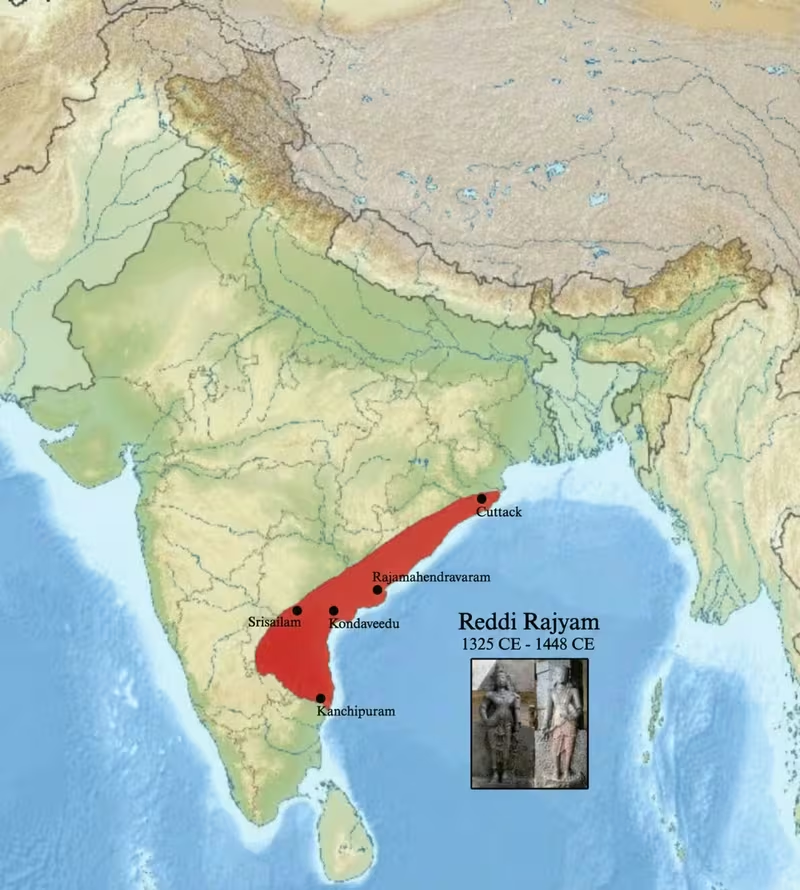
Reddy Kingdom at Its Maximum Extent
Introduction
From the coastal plains of Andhra to the inland stronghold of Srisailam, the Reddy Kingdom occupied a strategically varied region after the collapse of Kakatiya power. Founded by Prolaya Vema Reddi in 1325 CE, the kingdom eventually controlled much of coastal and central Andhra, with its maximum recorded reach extending from Cuttack in the north to Kanchi in the south and Srisailam in the west.
This map presents the Reddy realm during the broadest phase of its territorial history, while also showing the political changes that shaped its later contraction. Addanki served as the initial capital, but Anavota Reddi later established the fortified capital of Kondavidu. A separate Reddy branch appeared at Rajahmundry in 1395. The configuration did not remain stable: Kondavidu was annexed by the Vijayanagara Empire in 1424, and Rajahmundry was conquered by the Gajapatis approximately twenty-five years later.
Historical Context
The Reddy Kingdom emerged from the political crisis that followed the destruction of Kakatiya power. In 1323, the Delhi Sultanate invaded Warangal and captured the Kakatiya ruler Pratapa Rudra. Ulugh Khan then commanded Warangal and Telangana, but Tughlaq authority proved difficult to maintain across the Telugu-speaking country. Conflict among the invaders and resistance from local Telugu warriors contributed to the loss of the region by 1347.
Several regional powers arose from this unsettled political landscape. The Musunuris were initially based in coastal Andhra, the Recharlas became prominent in Telangana, and the Reddis established themselves along the coastal belt. The founders of the Reddy dynasty came from families connected with the Kakatiya military. Earlier records describe members of related Rattakudi families holding administrative positions, while a copperplate record identifies the founder’s grandfather as a sainya-nayaka, or military commander.
Prolaya Vema Reddi established the kingdom in about 1325 CE. His successor, Anavota Reddi, consolidated the territory and shifted the capital to Kondavidu. Later rulers, including Kumaragiri Reddi, Kataya Vema Reddi, and Pedakomati Vema Reddi, presided over a court associated with Telugu and Sanskrit literary production.
Territorial Extent and Boundaries
At its maximum recorded extent, the kingdom stretched northward to Cuttack in present-day Odisha, southward to Kanchi, and westward to Srisailam. Its principal zone of rule lay in what is now central Andhra and Rayalaseema, together with much of coastal Andhra. The eastern side of the kingdom was connected to the coast and to maritime commerce, while the interior included uplands, fortified hills, and the Palnadu region.
The map’s outer limits should be read as a representation of maximum political reach rather than a uniformly surveyed modern boundary. Medieval authority could vary between direct administration, military influence, and control exercised through local elites. The surviving record does not establish an equally precise frontier for every part of the kingdom.
Kondavidu, Kondapalli, Bellamkonda, Vinukonda, and Nagarjunakonda were among the important fortified locations associated with Reddy rule. Their distribution reflects the importance of controlling routes between the coast and the interior. The Krishna River and the wider riverine landscape of Andhra also shaped movement, agriculture, and access to settlements.
Administrative Structure
The Reddy kings governed according to the Dharmasutras, and agricultural taxation formed a central part of state revenue. One-sixth of the agricultural surplus was levied as tax. The political system combined royal authority with the influence of military and local elites, reflecting the dynasty’s origins among warrior families linked to the Kakatiya administration.
The sequence of capitals illustrates changing strategic priorities. Addanki was the first capital. Anavota Reddi later moved the royal centre to Kondavidu, a fortified site selected in part to protect the kingdom from repeated attacks by the Recherla Velama rulers and their Bahamani allies. Rajahmundry became the seat of a subsidiary Reddy branch founded in 1395. That branch subsequently became independent, giving the kingdom a more complex political structure than a single centrally controlled territory.
Infrastructure and Communications
The best-attested infrastructure of the Reddy period is military rather than bureaucratic. Kondavidu and Kondapalli were major hill forts, while Bellamkonda, Vinukonda, and Nagarjunakonda strengthened the Palnadu region. These strongholds served as defensive positions and as centres from which surrounding territory could be controlled.
The kingdom also maintained access to maritime commerce through Motupalli. A large number of merchants settled near the port, indicating that the coastal zone was connected to commercial networks beyond the immediate agrarian hinterland. The available record does not provide a detailed road map, postal system, or organized state communications network, so these features should not be inferred beyond the documented connections between capitals, forts, agricultural areas, and the port.
Economic Geography
Agriculture was central to the Reddy economy. The assessment of one-sixth of the agricultural surplus shows the importance of cultivated land to royal revenue. The coastal and central Andhra plains supplied the agrarian base, while inland areas and fortified uplands supported political and military control.
Trade policy appears to have had a significant effect under Anavota Reddi. Custom duties and taxes on trade were lifted during his reign, and commerce consequently flourished. Motupalli served as the principal named port associated with sea trade, and merchants settled in its vicinity. The map therefore links the kingdom’s interior capitals and fortifications with a coastal commercial outlet, although the surviving account does not identify specific imported or exported commodities.
Cultural and Religious Geography
The Reddy rulers patronised Hindu institutions and supported Brahmin learning. Brahmins received grants, agraharas were restored, and Vedic studies were encouraged. Temples at Srisailam, Tirumala, Vontimitta, and Ahobilam received royal support.
Prolaya Vema Reddi is associated with major repairs to the Mallikarjuna Swami temple at Srisailam and with the construction of a staircase from the Krishna River to the temple. The Narasimha Swamy temple at Ahobilam was built during his reign, and he is also credited with building 108 temples dedicated to Shiva.
The dynasty’s tutelary deity was Mullamguramma, originally a village goddess associated with Mullanguru, in present-day Guntur district. A temple dedicated to her was endowed with villages for regular worship. In the later capital of Rajamahendravaram, the deity was incorporated into the Shaiva tradition and identified with Uma, or Parvati.
Telugu literary culture developed strongly under the Reddy kings. Errapragada, also known as Errana, served as court poet to Prolaya Vema Reddi and completed the Telugu rendering of the Mahabharata begun by Nannaya. He also wrote the Hari Vamsa and Narasimha Purana. Sanskrit was patronised alongside Telugu, and several rulers were themselves regarded as scholars and authors.
Military Geography
The kingdom’s defensive geography centred on hill forts and access routes between the coast and the plateau. Kondavidu was the principal fortified capital, while Kondapalli stood approximately 20 kilometres northwest of present-day Vijayawada. The fortifications at Bellamkonda, Vinukonda, and Nagarjunakonda extended the defensive network across Palnadu.
Reddy power developed in an environment of rivalry with the Recherla Velama rulers, whose conflicts with the Reddis were reinforced by Bahamani alliances. The move from Addanki to Kondavidu was therefore both an administrative and military decision. No complete list of battles or army strengths is securely preserved in the available record, but the concentration of forts demonstrates the importance of territorial defence and control of strategic approaches.
Political Geography
The Reddy Kingdom occupied a contested space created by the decline of Kakatiya authority. It interacted with the Musunuris in coastal Andhra, the Recharlas in Telangana, the Bahamani Sultanate, and later the expanding Vijayanagara Empire. The northern and eastern political landscape also brought the kingdom into contact with the Gajapatis.
The Rajahmundry branch illustrates the limits of dynastic unity. Established in 1395, it later became independent before being conquered by the Gajapatis. Kondavidu, meanwhile, was annexed by Vijayanagara in 1424. These developments show that the map’s maximum extent represents a phase of expansion rather than a permanent political settlement.
Legacy and Decline
The Reddy Kingdom lasted from approximately 1325 to 1448 CE, ruling coastal and central Andhra for more than a century. Its decline resulted from pressure by larger neighbouring powers and from the fragmentation of its own political structure. Vijayanagara took Kondavidu in 1424, while the Gajapatis conquered Rajahmundry about twenty-five years later.
The Gajapatis eventually lost coastal Andhra after Gajapati Prataprudra Deva was defeated by Krishna Deva Raya of Vijayanagara. The Reddy legacy nevertheless remained visible in Andhra’s fortifications, temple patronage, agrarian administration, and Telugu literary history. On the map, the kingdom appears not simply as a territorial unit but as a network joining fortified capitals, sacred centres, cultivated plains, and the maritime port of Motupalli.