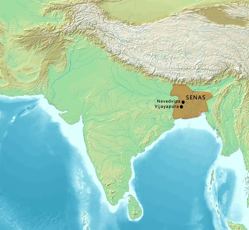
Sena Dynasty Territory, c. 1179–1204 CE
Introduction
The Sena map is shaped by a contrast: a dynasty rooted in Bengal reached its widest recorded political horizon under Lakshmana Sena, yet its capital at Nadia was captured by Muhammad Bakhtiyar Khalji in 1203–1204 CE. The territory shown here therefore represents both the high point of Sena expansion and the beginning of the political reorganisation that followed.
The Sena dynasty succeeded the Pala Empire in much of eastern India. Its rulers consolidated power in Bengal, absorbed the remaining Pala territories after the mid-12th century, and extended their influence into the Bengal Delta and toward Odisha. A copperplate inscription issued under Keshava Sena also associates Lakshmana Sena with victory pillars and sacrificial posts at Varanasi, Allahabad and a place described as the Adon Coast of the South Sea. These references may indicate a wider sphere of military activity or royal claims, but they do not provide a precise, continuous western or southern boundary.
This map consequently distinguishes between the Sena core in Bengal and regions linked with expansion or royal claims. The most securely established political geography lies in Bengal, including Vaṅga, parts of Varendra and the deltaic region. Odisha and the possible extension toward Varanasi are shown as areas of expansion or claimed reach rather than as uniformly administered provinces.
Historical Context
From Pala service to regional sovereignty
The Sena rulers traced their origin to southern India. The Deopara Prashasti describes Samanta Sena, the founder of the dynasty, as a migrant Brahmaksatriya from Karnataka. The term “Brahma-Kshatriya” has been interpreted as referring to Brahmins who adopted the profession of arms and became associated with Kshatriya status. Historian P. N. Chopra also identified the Sena kings as probably Baidyas, although the social classification of the dynasty remains debated.
The Senas appear to have settled in western Bengal before the birth of Samanta Sena. They entered the service of the Palas as sāmantas, or subordinate chiefs, in Rāḍha. This early relationship is central to understanding the map. The dynasty did not begin as an already established empire extending across eastern India. It developed within the political world of the Pala realm and expanded as Pala authority weakened.
Samanta Sena was followed by Hemanta Sena. In 1095 CE, Hemanta Sena usurped power and styled himself king. This act marks the transition from subordinate regional authority to independent kingship.
Vijaya Sena and the foundations of Sena power
Vijaya Sena succeeded Hemanta Sena and ruled from 1096 to 1159 CE. His reign lasted more than six decades and helped lay the institutional and territorial foundations of Sena power. By the end of Vijaya Sena’s reign, Sena territory had expanded to include Vaṅga and part of Varendra in addition to earlier areas in Bengal.
The map’s core territory should therefore be understood as the result of gradual consolidation rather than one single conquest. Rāḍha formed an early base. Vaṅga represented the eastern and deltaic dimension of Sena rule. Varendra, associated with northern Bengal, marked the dynasty’s advance into territory that had been connected with the Pala political sphere.
Ballala Sena and the conquest of Gaur
Ballala Sena succeeded Vijaya Sena. He conquered Gaur from the Palas and became ruler of the Bengal Delta. Gaur’s position in the northern Bengal region gave the dynasty a political and strategic centre, while control of the delta connected Sena authority with the dense agricultural and riverine landscape of eastern Bengal.
Ballala Sena is also associated with Nadia, which he made a capital. The political geography of the dynasty was not limited to a single urban centre, however. The record specifically cautions that Navadvip, often identified with Nadia, was not the permanent capital of all Sena rulers. It is therefore more accurate to show Nadia as an important royal centre during a particular phase rather than as an unchanging capital throughout Sena history.
Ballala Sena married Ramadevi, a princess of the Western Chalukya Empire. This marriage indicates social and diplomatic contact between the Sena court and southern India. It is evidence of a relationship across the subcontinent, but the available record does not establish a Western Chalukya dependency or territorial connection to Sena Bengal.
Lakshmana Sena and the widest recorded horizon
Lakshmana Sena succeeded Ballala Sena in 1179 CE. He ruled Bengal for approximately twenty years and is generally regarded as the last significant Sena ruler. During his reign, Sena authority expanded toward Odisha and possibly as far as Varanasi.
The word “possibly” is important for reading the map. The Keshava Sena copperplate states that Lakshmana Sena erected pillars of victory and sacrificial posts at Varanasi, Allahabad and the Adon Coast of the South Sea. Such references demonstrate the geographical ambition of the royal record. They may refer to military successes, ceremonial claims or a combination of both. They do not, by themselves, establish that the entire route from Bengal to these places was permanently administered by the Sena state.
The map therefore presents Varanasi and Allahabad as locations connected with Sena victory claims rather than as undisputed parts of a uniformly governed empire. This distinction avoids turning a record of royal achievement into an artificially precise political boundary.
The capture of Nadia
In 1203–1204 CE, Muhammad Bakhtiyar Khalji, a general under the Ghurid Empire and protégé of Qutbuddin Aibak, invaded Sena territory and captured Nadia. The event is described in the Tabaqat-i Nasiri. The capture of the capital region marked a decisive break in the political order of Bengal.
Nadia’s fall did not immediately erase all Sena authority. Lakshmana Sena’s sons Vishvarupa Sena and Keshava Sena probably ruled until at least 1230 CE. The Tabaqat-i Nasiri indicates that descendants of Lakshmana Sena continued to rule in Bengal, or Bang, until at least 1245 or 1260 CE. The dates and extent of this continued rule are not uniform in the surviving record, so the map should be read as a representation of the late 12th-century Sena configuration rather than a claim that the dynasty disappeared in 1204.
Territorial Extent and Boundaries
The Bengal core
The most securely established Sena territory lay in Bengal. The dynasty’s expansion included:
- Rāḍha, where the early Sena chiefs served the Palas;
- Vaṅga, associated with eastern Bengal;
- part of Varendra, in northern Bengal;
- the Bengal Delta;
- Gaur, conquered from the Palas;
- Nadia, a royal centre associated with Ballala Sena and later captured by Bakhtiyar Khalji.
These regions formed the political heartland shown in the darker colour on the map. Their exact internal boundaries cannot be reconstructed as modern provincial lines. Early medieval political authority was not necessarily organised through fixed borders of the kind used by modern states. A ruler’s effective control could vary between royal centres, landholding elites, religious institutions and frontier zones.
Northern frontier
The available record does not provide a single clearly defined northern boundary for the Sena kingdom. Varendra formed part of the expanded territory by the end of Vijaya Sena’s reign, placing Sena power in northern Bengal. The wider Himalayan and Nepalese region should not be coloured as Sena territory on the basis of the evidence available here.
A later Sena dynasty emerged in the southern parts of Nepal near the Bihar border during the 16th century. That later dynasty used the Sena surname and claimed descent from the Senas of Bengal, but it belongs to a much later historical context. The later Sena branch of Makwanpur should not be projected backward onto the 12th-century map.
Eastern frontier
The Bengal Delta formed a major eastern component of Sena rule. Its landscape of rivers, distributaries, floodplains and wetlands created both opportunities and challenges for political control. Ballala Sena is specifically described as the ruler of the Bengal Delta.
The eastern frontier should not be extended automatically across all areas of present-day Bangladesh or beyond. The record names parts of Bengal and the delta but does not establish a continuous border toward the far northeast. The map therefore uses a broad historical zone rather than a sharply drawn modern frontier.
The Keshava Sena copperplate is associated with the Adilpur or Edilpur pargana of the former Faridpur District. It records a grant of three villages in the third year of Keshava Sena. The land lay in the village of Leliya, in the Kumaratalaka mandala, within shatata-padamavati-visaya. The grant also refers to authority over the Chandrabhandas, or Sundarbans, a forest-dwelling community. This inscription provides a detailed glimpse of Sena landholding and jurisdiction in the deltaic environment.
Southern frontier
Lakshmana Sena’s expansion toward Odisha is recorded in broad terms. The available account does not define whether Odisha was directly annexed, placed under tributary authority or reached through military campaigns and royal claims. The map marks Odisha as an expanded or possibly claimed region rather than applying the same colour used for the Bengal core.
The copperplate’s reference to the “Adon Coast of the South Sea” suggests a southern or southeastern point associated with Lakshmana Sena’s victories. The precise identification of this place and the political meaning of the reference are not established here. It should therefore be treated as an uncertain point in the royal geography of the inscription.
Western frontier
The possible western reach of the Sena dynasty is associated with Varanasi and Allahabad. The Keshava Sena copperplate says that Lakshmana Sena erected victory pillars and sacrificial posts at both places. These references are geographically significant because they place Sena royal claims beyond the Bengal heartland.
They should not, however, be translated directly into a solid western boundary. A victory pillar can commemorate a campaign, a royal expedition, a ceremonial act or a claim of supremacy without demonstrating lasting administrative occupation. Varanasi and Allahabad are therefore marked on the map, but the intervening territory is not represented as securely administered Sena land.
Direct rule, subordinate authority and royal claims
The political vocabulary of the period included relationships that cannot always be represented by modern territorial colouring. The Senas themselves began as sāmantas under the Palas. Their later rise illustrates how subordinate political authority could become independent as an imperial centre weakened.
Similarly, the references to Odisha, Varanasi and Allahabad may represent different degrees of authority. Some areas may have been directly governed; others may have acknowledged Sena power temporarily; still others may appear in royal inscriptions because they were locations of military or ceremonial activity. The map uses separate categories to reflect these distinctions.
Administrative Structure
Royal authority
The Sena state was headed by a hereditary royal house. Samanta Sena founded the line, Hemanta Sena assumed kingship in 1095 CE, Vijaya Sena consolidated the dynasty, Ballala Sena expanded its control in Bengal, and Lakshmana Sena presided over the final major phase of territorial growth.
The royal record presents kingship through conquest, victory, religious patronage and land grants. The Keshava Sena copperplate is particularly valuable for showing how authority operated at the local level. It records the grant of three villages to a Brahmin in Keshava Sena’s third year, with landlord rights and powers that included punishing the Chandrabhandas or Sundarbans community.
Regional divisions
The copperplate names several administrative units:
- mandala, including Kumaratalaka;
- visaya, including shatata-padamavati-visaya;
- villages such as Leliya;
- a broader grant region described as the interior of subha-varsha.
These terms indicate a layered administrative geography. The exact hierarchy and boundaries of each unit are not fully recoverable from the available information, but the inscription shows that royal authority was expressed through named territorial divisions and village-level grants.
The land grant also demonstrates the importance of rights, not merely possession. The beneficiary received landlord rights and jurisdictional powers. Such grants connected the king, Brahmin recipients, local communities and agrarian production.
Capitals and political centres
Nadia became a capital under Ballala Sena. It was later captured by Muhammad Bakhtiyar Khalji. The record explicitly notes that Navadvip was not the permanent capital of the Sena rulers, so the map avoids presenting the dynasty as governed from Nadia throughout its history.
Gaur was another major political centre. Ballala Sena conquered it from the Palas. Its position in northern Bengal made it a significant node in the dynasty’s territorial consolidation.
The absence of a securely documented single permanent capital for the entire dynasty is itself important. Sena political geography appears to have included several royal centres whose significance changed over time.
Local authority and social organisation
The Senas consolidated the caste system known as Kulinism in Bengal. This process formed part of their social and administrative legacy. Later traditions connected the dynasty with Kayasthas, Baidyas and Brahmins in different ways. Abul Fazl later wrote that Bengal had always been ruled by Kayasthas, while premodern Baidya genealogies claimed the Senas and some Brahmin genealogies accepted that connection. Kayastha genealogies rejected it.
The actual caste status of the Senas remains contested. The map should not encode later genealogical claims as settled historical fact. It is more useful to show that the dynasty’s political legacy became embedded in competing social memories.
Infrastructure and Communications
What can be mapped securely
The surviving information provides evidence for political centres, land grants, temples, inscriptions and military movement. It does not preserve a complete Sena road map, postal system or standardised communications network. No securely reconstructed network of roads can therefore be drawn as though it were documented in detail.
The geography of Bengal itself would have made waterways highly significant. The Bengal Delta was defined by rivers and distributaries, and its agricultural settlements were closely related to the movement of people, goods and authority through a wetland environment. Yet the specific Sena-era waterways used for state communication are not identified in the available record.
Riverine geography
The Ganges river system and the deltaic waterways provided the physical framework for Bengal’s political economy. River channels could connect agrarian settlements with royal centres, but they could also shift, flood and divide territories. Such conditions complicate the drawing of fixed boundaries.
The Adilpur or Edilpur grant, with its references to villages, rice cultivation and the Sundarbans, illustrates how the Sena administration operated in a landscape where settled agriculture and forest zones existed alongside one another. The authority to punish forest communities indicates that the state’s interests extended beyond cultivated fields.
Roads and long-distance movement
The copperplate’s references to Varanasi, Allahabad and the southern coast imply that Sena rulers or their armies could project power over long distances, but the evidence does not specify the roads followed. Nor does it establish a permanent imperial communications service.
The marriage of Ballala Sena with Ramadevi, a Western Chalukya princess, demonstrates long-distance social contact between Bengal and southern India. Marriage alliances required movement across considerable distances, but the available record does not identify the routes, escorts or institutions that supported this connection.
Maritime capabilities
The Bengal Delta opened onto the Bay of Bengal, and the copperplate mentions the Adon Coast of the South Sea. These facts indicate a geographical orientation toward the coast. They do not, by themselves, prove that the Sena dynasty maintained a large navy or a clearly documented maritime empire.
The map therefore shows the coastline as a geographical setting rather than marking a naval zone. Any reconstruction of Sena maritime power would require additional evidence beyond the record used here.
Economic Geography
Agrarian Bengal
Agriculture formed the foundation of the Sena political landscape. The Keshava Sena copperplate describes villages with smooth fields producing excellent paddy. This description is especially relevant to the Bengal Delta, where alluvial soils, seasonal flooding and abundant water supported intensive rice cultivation.
The land grant shows how agricultural production was linked to political authority. Villages could be transferred to Brahmins with landlord rights and jurisdictional privileges. Such grants created enduring relationships between royal power, landed beneficiaries and cultivating communities.
Cowries and silver currency
Sena writings mention several currency terms, including purana, chalana, dharan and dramma. These terms referred to a silver coin weighing 32 ratis, or 56.6 grains, or to a karshapan weight standard.
Another important term was kapardaka-purana. “Kapardak” means cowrie in Sanskrit, while “chalana” means coin. The expression referred to a medium of exchange whose value was treated as equivalent to a silver purana, even though payment was made through cowries. Traditional arithmetic tables in Bengal used 1,260 cowries in place of one silver coin, while the stated ratio of purana to kapardaka was 1:1,280.
The difference between these figures reflects the complexity of historical accounting rather than a modern fixed exchange rate. The wider point is clear: precious coins were scarce in early medieval Bengal, and cowries circulated widely. Archaeological excavations at Paharpur and Kalgang near Bhagalpur have produced reliable evidence for this use of cowries.
Market exchange and regional integration
The use of cowries connected village economies with broader systems of exchange. A grant in the delta, a royal court at Nadia or Gaur, and agricultural villages producing paddy were all part of the same economic landscape, although the precise mechanisms of collection and redistribution are not documented here.
The availability of rice, the presence of riverine settlements and the use of cowries suggest a region where local exchange was highly developed. It would be misleading, however, to assign specific export commodities, port duties or commercial routes without direct evidence.
Urban and political centres
Gaur and Nadia appear in the political record as major centres. Dhaka is significant in the architectural tradition through Dhakeshwari Temple, attributed to Ballala Sena in the 12th century. The available account does not provide population estimates for these places, nor does it establish their precise economic specialisations.
For this reason, the map uses these locations as political or cultural points rather than presenting them as fully documented urban-commercial hierarchies.
Cultural and Religious Geography
Hindu kingship and temple building
The Sena dynasty is notable for Hindu temple and monastery construction. Ballala Sena is traditionally credited with building Dhakeshwari Temple in the 12th century CE in what is now Dhaka. The temple’s association with the Sena period gives the eastern delta a significant place in the dynasty’s religious geography.
The dynasty is also likely to have built a temple in Kashmir known as Sankara Gaureshwara. This attribution is expressed cautiously because the available record identifies the connection as probable rather than certain. Kashmir should not therefore be coloured as a securely controlled Sena province.
Religious institutions and land grants
The Keshava Sena copperplate records a grant to the Brahmin Nitipathaka Isvaradeva Sarman. The grant demonstrates the role of royal patronage in supporting Brahmin beneficiaries and embedding religious authority in local agrarian society.
The inscription also provides a glimpse into the cultural world of the period. It describes music and dancing in ancient Bengal and mentions women adorned with blooming flowers. These details are not merely decorative: they show that royal and landed society was represented through cultivated landscapes, ritual practice, performance and aesthetic display.
Sanskrit and Bengali literary culture
The Sena court supported literary activity. During the Pala and Sena periods, the development of Bengali was witnessed. At Lakshmana Sena’s court, poets included Govardhana, Sarana, Jayadeva, Umapati and Dhoyi or Dhoyin.
The coexistence of Sanskritic royal culture and the developing Bengali linguistic world is an important feature of the map’s cultural geography. The available record does not provide a precise language boundary, and medieval linguistic regions cannot be equated directly with modern administrative borders. It is nevertheless clear that Bengal was a centre of literary production during the Sena period.
Social consolidation
The Senas consolidated Kulinism in Bengal. This institution helped structure social status and marriage relationships among elite groups. Later accounts connected the dynasty to different caste communities, but these claims should be treated as part of the dynasty’s changing social memory rather than as an uncontested description of its origins.
The Deopara Prashasti’s description of Samanta Sena as a migrant Brahmaksatriya from Karnataka, the later Baidya claims and Kayastha traditions all contribute to a layered picture of identity. The dynasty’s southern origin and Bengal-based kingship remained important elements in later historical interpretation.
Military Geography
From Pala service to conquest
The military geography of the Sena dynasty began in the service of the Palas. The Senas served as sāmantas in Rāḍha before expanding their own power. This transition meant that the dynasty possessed experience within an established political and military order before becoming an independent ruling house.
Vijaya Sena’s long reign provided the conditions for expansion into Vaṅga and part of Varendra. Ballala Sena then conquered Gaur from the Palas and secured the Bengal Delta. The complete annexation of Pala territory occurred sometime after 1165 CE.
Royal victory claims
The Keshava Sena copperplate presents Lakshmana Sena as a victorious ruler who erected pillars and sacrificial posts at Varanasi, Allahabad and the southern coast. These sites form the widest geographical arc associated with Sena military achievement.
The inscription also praises Ballala Sena for carrying away the goddesses of fortune from enemies on palanquins supported by elephant-tusk staffs. This is a conventional royal image of victory and should be read as political praise rather than as a literal logistical account.
The map marks the named sites but distinguishes them from the Bengal heartland. The evidence indicates military or ceremonial reach; it does not settle whether Sena authority remained in place after each campaign.
Nadia and the Ghurid advance
The capture of Nadia in 1203–1204 CE was the decisive military event of the dynasty’s decline. Muhammad Bakhtiyar Khalji, operating under the wider authority of the Ghurid Empire and connected with Qutbuddin Aibak, launched the invasion and captured the capital city.
The Tabaqat-i Nasiri provides the detailed account of this invasion. Nadia’s position as a royal centre made its capture symbolically and politically important, even though Sena power continued in parts of Bengal under Lakshmana Sena’s descendants.
Strongholds and defensive geography
The available record does not identify a complete system of Sena forts or frontier garrisons. Makwanpur Gadhi, associated with a later Sena branch in Nepal, cannot be used as evidence for the 12th-century Bengal dynasty. Similarly, no securely documented list of military bases or army distributions is available.
The map therefore focuses on the geography of conquest, royal centres and named victory sites rather than inventing a network of fortifications. Bengal’s rivers, wetlands and deltaic terrain would have shaped military movement, but the specific defensive strategies of Sena commanders are not established in the record used here.
Army organisation
No reliable army sizes or detailed Sena military formations are provided. The account identifies rulers, subordinate chiefs, campaigns and the invasion led by Muhammad Bakhtiyar Khalji, but it does not preserve numerical descriptions of Sena forces.
It is therefore not possible to state how many soldiers defended Nadia, how many troops participated in the campaigns toward Odisha or Varanasi, or how the army was distributed among provinces. Any such figures would go beyond the documented evidence presented for this map.
Political Geography
Relationship with the Palas
The Sena–Pala relationship changed over time. The early Senas entered Pala service as subordinate chiefs in Rāḍha. As Pala power declined, the Senas expanded into Vaṅga and Varendra. By the end of Vijaya Sena’s reign, their territorial base had become substantially larger.
The Palas were ousted entirely and their territory was annexed sometime after 1165 CE. This transition explains why the map presents the Sena dynasty as the successor power across much of eastern India rather than as a separate kingdom confined to a small Bengal region.
Contact with southern India
Ballala Sena’s marriage to Ramadevi, a princess of the Western Chalukya Empire, indicates close social contact with south India. This relationship is best understood as dynastic and diplomatic connection. It does not demonstrate territorial control over Western Chalukya lands.
The Sena tradition of southern origin also gave this relationship added importance. The dynasty’s memory linked Karnataka with its ancestral past while its political power was centred in Bengal.
Odisha and Varanasi
Lakshmana Sena expanded toward Odisha and possibly up to Varanasi. These regions occupy a middle position in the map: they are not treated as purely external, but neither are they shown with the same certainty as the Bengal core.
The distinction reflects the nature of the evidence. A royal inscription could celebrate victory over distant enemies or identify ritual acts at prestigious sites. Such evidence is valuable for reconstructing a ruler’s sphere of ambition and political language, but it may not reveal the duration or administrative depth of control.
Later Sena continuity
After Lakshmana Sena, his sons Vishvarupa Sena and Keshava Sena probably ruled until at least 1230 CE. The Tabaqat-i Nasiri suggests that descendants of Lakshmana Sena retained authority in Bengal until at least 1245 or 1260 CE.
These later dates show that the capture of Nadia did not end every form of Sena rule. The dynasty’s political geography contracted and changed, but the royal house continued in parts of Bengal. The precise location and extent of this later authority remain uncertain in the available record.
Reading the Map’s Uncertain Boundaries
Historical maps of early medieval India can create a false impression of precision. Modern maps use clean borders, but the Sena political landscape was likely composed of zones with varying levels of authority. Royal centres, agrarian villages, forest communities, subordinate chiefs and conquered regions did not necessarily share the same administrative status.
Three distinctions are especially important:
- Core territory: Bengal regions directly associated with Sena consolidation, including Vaṅga, parts of Varendra, the Bengal Delta, Gaur and Nadia.
- Expanded or claimed territory: Odisha and the possible western reach toward Varanasi.
- Named victory or ceremonial locations: Varanasi, Allahabad and the Adon Coast, which appear in the Keshava Sena copperplate but cannot automatically be treated as permanently administered provinces.
The map’s shaded areas are therefore interpretive historical zones. They communicate the geography of Sena power without claiming that every village, forest or frontier was governed in exactly the same way.
Legacy and Decline
The decline after Lakshmana Sena
The Sena dynasty began to decline under weak rulers after the reign of Lakshmana Sena. The invasion led by Muhammad Bakhtiyar Khalji and the capture of Nadia exposed the vulnerability of the political order, but Sena authority survived in parts of Bengal for decades.
The dynasty’s decline was consequently gradual rather than instantaneous. The dates proposed for the continuation of Sena rule range from at least 1230 CE for the reigns of Vishvarupa Sena and Keshava Sena to at least 1245 or 1260 CE for the rule of Lakshmana Sena’s descendants in Bang. The variation reflects the limits of the surviving historical record.
Administrative and cultural legacy
The Sena period left a lasting mark on Bengal’s social, religious and literary history. The consolidation of Kulinism shaped elite social organisation. Temple and monastery patronage strengthened Hindu institutions. The association of Ballala Sena with Dhakeshwari Temple remains an important part of the architectural memory of the region.
The court of Lakshmana Sena supported poets including Jayadeva, Govardhana, Sarana, Umapati and Dhoyi. Their presence reflects the importance of literary patronage in the late Sena court and the wider development of Bengali cultural history during the Pala–Sena transition.
The dynasty’s economic world also left evidence in the form of inscriptions and archaeological finds. The circulation of cowries, the scarcity of precious coins and the agricultural wealth of the delta reveal a regional economy that cannot be understood only through royal conquest.
Later claims of descent
In the 16th century, a dynasty in southern Nepal near the Bihar border adopted the Sena surname and claimed descent from the Senas of Bengal. One branch became the Sena dynasty of Makwanpur and ruled from Makwanpur Gadhi. It adopted Maithili as its state language.
This later dynasty belongs to a different period and political environment. Its claim of descent is part of the history of Sena memory, not proof that the 12th-century Bengal dynasty directly controlled southern Nepal.
Conclusion
The Sena dynasty map is best understood as a layered picture of Bengal-centred kingship. Its darkest zone is the territory consolidated through the decline of Pala power: Rāḍha, Vaṅga, parts of Varendra, the Bengal Delta, Gaur and Nadia. Its lighter zones represent the more uncertain geography of Lakshmana Sena’s expansion toward Odisha and the royal claims associated with Varanasi, Allahabad and the southern coast.
The capture of Nadia in 1203–1204 CE transformed this political landscape, but it did not immediately erase Sena rule. The dynasty continued through Lakshmana Sena’s descendants, while its social, religious, literary and economic legacies remained embedded in Bengal’s history. Read with attention to the difference between direct rule, expansion and inscriptional claim, the map shows not a rigid empire with perfectly fixed borders, but a changing network of royal authority across eastern India.