Travancore at Its Zenith: Territory, Capitals, and Campaigns
Introduction
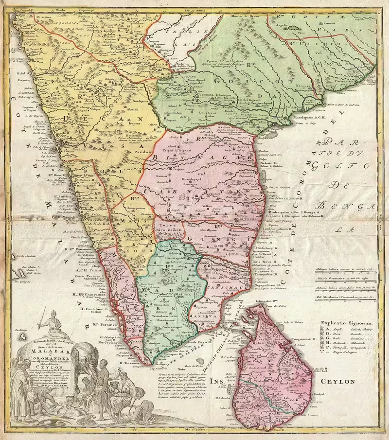
The map of Travancore at its 18th-century height is a map of transformation: a relatively small principality called Venad became a consolidated kingdom extending from Kanyakumari in the south to the borders of Cochin in the north. This expansion took place under Anizham Tirunal Marthanda Varma, who ruled from 1729 to 1758 and used military campaigns, administrative consolidation, and the defeat of rival powers to create Travancore.
The kingdom occupied the extreme southern tip of the Indian subcontinent. Its territory combined coastal plains along the Arabian Sea, rolling midlands, and rugged highlands linked to the Western Ghats. The map also places Travancore within a wider political landscape: Cochin lay to the north, the Madurai and Tirunelveli districts of the Madras Presidency lay to the east in later geographic descriptions, and the Arabian Sea and Indian Ocean bordered its western and southern sides.
This map moment matters because Travancore’s territorial shape was not the product of a single inherited boundary. It emerged from the absorption of smaller principalities during Marthanda Varma’s reign, the defeat of the Dutch at Colachel in 1741, the victory over the Zamorin at Purakkad in 1755, and the extension of Travancorean power towards Cochin. Later rulers altered the capital, administrative divisions, political status, and boundaries, but the expansion of the 18th century established the territorial foundation of the kingdom that lasted until its merger with Cochin in 1949.
Historical Context
From Ay territory to Venad
The southern part of present-day Kerala had a long political history before Travancore. The Ay dynasty ruled a territory extending, at its height, from Nagercoil in the south to Thiruvananthapuram in the north. Its early capital was at Aykudi, and by the later 8th century its political centre had shifted towards Quilon, now Kollam.
The Ay realm was affected by repeated attacks from the Pandyas during the 7th and 8th centuries. Although the dynasty remained powerful until the beginning of the 10th century, its decline allowed Venad to emerge as the southernmost principality of the Second Chera Kingdom. After the Chera political order weakened, Venad developed as an independent royal house.
The history of Venad was closely associated with Kollam, also known as Quilon. The city served as a capital and port, while other royal residences were maintained at Thiruvithamcode and later at Kalkulam. The rulers of Venad retained the title Kulasekara, connecting the later royal house with the Chera tradition.
In the second half of the 12th century, two branches of the Ay dynasty, associated with Thrippappur and Chirava, merged into the Venad family. This union helped establish the political terminology of the kingdom: the ruler was designated the Chirava Moopan, while the heir apparent was the Thrippappur Moopan. The latter was based at Thrippappur, north of present-day Thiruvananthapuram, and held authority over the temples of Venad, especially the Sri Padmanabhaswamy Temple.
The rise of Marthanda Varma
Marthanda Varma inherited the small feudal state of Venad in 1723 and became its ruler in 1729. His reign marked the decisive transition from Venad to Travancore. Over 29 years, he defeated or absorbed smaller principalities and extended his authority from Kanyakumari in the south to the borders of Cochin in the north.
The consolidation was not merely a matter of drawing a larger boundary. Marthanda Varma had to defeat feudal lords, establish internal peace, and bring local political centres under the authority of the royal state. The campaigns were supported by administrators and military commanders, including Ramayyan Dalawa, who served as prime minister from 1737 to 1756.
The new kingdom adopted the name Thiruvithamkoor, anglicised by the English as Travancore. The name ultimately derived from Thiruvithamcode in present-day Kanyakumari district. Although the political centre later moved to Padmanabhapuram and then to Thiruvananthapuram, the older place-name continued to designate the kingdom.
The Travancore–Dutch War
Travancore’s expansion brought it into conflict with the Dutch East India Company, which had allied with several of the smaller kingdoms in the region. The Travancore–Dutch War began in 1739 and continued through the 1740s.
The decisive event was the Battle of Colachel in 1741. Travancore defeated the Dutch forces, captured the Dutch captain Eustachius De Lannoy, and significantly weakened Dutch influence in the region. De Lannoy later entered Travancore’s service. He became captain of the ruler’s bodyguard and later held the title Valiya Kappittan, or Senior Admiral. From 1741 to 1758 he commanded Travancore’s forces and participated in the annexation of smaller principalities.
The victory at Colachel is remembered as an early example of an organised Asian power overcoming European military technology and tactics. It also had a direct territorial consequence: the Dutch could no longer act as the decisive external force supporting Travancore’s rivals.
Consolidation after Colachel
Marthanda Varma continued his expansion after Colachel. At the Battle of Ambalapuzha, he defeated a coalition that included deposed rulers and the king of Cochin. In 1755, Travancore defeated the Zamorin of Kozhikode at Purakkad, becoming the dominant state in the Kerala region.
The political geography represented by the map therefore includes more than the territory directly inherited from Venad. It shows a kingdom enlarged through campaigns against local rulers, fortified by a more centralised military system, and positioned as a major power between the Malabar Coast and the Tamil-speaking regions east of the Western Ghats.
The Padmanabha dedication
On 3 January 1750, Marthanda Varma dedicated Travancore to his tutelary deity Padmanabha, an aspect of Vishnu. After this act, the rulers of Travancore governed as servants of Padmanabha, or Padmanabha-dasas.
This dedication shaped the political culture of the kingdom. The monarch’s authority was expressed through service to the deity rather than solely through personal sovereignty. The Sri Padmanabhaswamy Temple became central to the religious and political geography of Travancore, while Thiruvananthapuram gained growing significance as a royal and sacred centre.
Territorial Extent and Boundaries
Southern frontier
The southern limit of Travancore reached Kanyakumari, the southernmost point of the Indian subcontinent. The territory included the region now identified with Kanyakumari district and extended into areas associated with Tenkasi district.
The southern districts were culturally and linguistically mixed. The Padmanabhapuram Division, described in the 1911 census, consisted largely of the present-day Kanyakumari district and was predominantly Tamil-speaking. Thovalai and Agastheeswaram were regarded as geographically closer to Pandya Nadu and the eastern Coromandel region than to the Malayalam-speaking areas farther north and west.
Kanyakumari was therefore both a geographic endpoint and a zone of cultural contact. The map’s southern edge should not be read as a sharp linguistic frontier. Tamil-speaking populations lived within Travancore, while Malayalam-speaking communities were also present in parts of the southern divisions.
Northern frontier
At its height under Marthanda Varma, Travancore extended northward to the borders of the Cochin kingdom. Travancore’s victory at Ambalapuzha and its later dominance in the Kerala region strengthened this northern position.
The later administrative geography of Travancore included major portions of modern Ernakulam district and the village of Puthenchira in present-day Thrissur district. These northern extensions should be distinguished from the core territory around Thiruvananthapuram, Kollam, and Kanyakumari.
The northern frontier was politically changeable. Cochin remained a neighbouring kingdom, and relations between the two states could involve both conflict and cooperation. The map therefore represents a zone of interaction rather than an entirely immutable line.
Eastern frontier
The Western Ghats formed the major geographic barrier along Travancore’s eastern side. Beyond the mountain system lay the Tamil-speaking districts connected with Madurai and Tirunelveli in the Madras Presidency and the wider regions of Pandya Nadu and Kongu Nadu.
The eastern terrain was not uniform. Travancore’s eastern highlands were rugged and cooler than the coast, while the central region consisted of rolling midlands. The Western Ghats restricted easy movement between the Malabar Coast and the Tamil country, but they did not prevent political, military, linguistic, or commercial connections.
Later divisions such as Devikulam included areas associated with the Cardamom Hills and were connected culturally and geographically with Pandya Nadu and Kongu Nadu. The eastern frontier was consequently a highland borderland with mixed populations and changing administrative significance.
Western and southern maritime frontiers
The Arabian Sea lay to the west and the Indian Ocean to the south. The coast gave Travancore access to maritime commerce and to the historic port of Kollam. The coastal lowlands supported dense settlement, ports, temple centres, and political networks distinct from the upland interior.
Not every coastal area near Travancore was under Travancorean authority. Tangasseri in Kollam and Anchuthengu near Attingal were British possessions, even though they were geographically surrounded by or adjacent to Travancore. Their presence demonstrates that coastal boundaries were shaped not only by local kingdoms but also by European colonial enclaves.
Core territory and changing boundaries
The broad core of Travancore included the areas corresponding to modern Idukki, Kottayam, Alappuzha, Pathanamthitta, Kollam, and Thiruvananthapuram districts, along with major portions of Ernakulam, Puthenchira in Thrissur, Kanyakumari district, and parts of Tenkasi.
These modern district names are useful for orientation but should not be projected backward as historical administrative units. Travancore was organised through divisions and taluks whose boundaries changed over time. The map’s territorial area therefore indicates the kingdom’s general extent rather than a precise modern boundary line.
Administrative Structure
Capitals and royal residences
Travancore’s political geography developed through a sequence of capitals and royal residences.
Kollam was the principal capital of Venad, known in older terminology as Venad Swaroopam or Desinganadu. It was also one of the oldest ports on the Malabar Coast and remained an important political and commercial centre.
Thiruvithamcode became the capital of the Thrippapur branch of the royal family and gave its name to the later kingdom. European usage preserved the name even after the capital moved.
In 1601, the capital shifted to Padmanabhapuram, near Kalkulam. Padmanabhapuram became the principal royal seat during the period of Travancore’s expansion under Marthanda Varma. It remained the capital until 1795.
In 1795, Karthika Thirunal Rama Varma, known as Dharma Raja, shifted the capital to Thiruvananthapuram. This move strengthened the importance of the city and aligned the political capital more closely with the Padmanabha-centred religious order of the kingdom.
Divisions and local administration
Travancore’s administration was headed by the king and supported by a Dewan. The Dewan was assisted by officials including the Neetezhutthu Pillay, a secretary; the Rayasom Pillay, an assistant or under-secretary; Rayasoms, who served as clerks; and Kanakku Pillamars, who worked as accountants.
District-level administration was handled by Sarvadhikaris under the supervision of the Dewan. Relations with neighbouring states and European powers came under the Valia Sarvahi, who signed treaties and agreements.
The kingdom was divided into major territorial units whose names and boundaries changed with administrative reform. A five-division structure included Padmanabhapuram, Thiruvananthapuram, Quilon, Kottayam, and Devikulam.
Padmanabhapuram and Devikulam were predominantly Tamil-speaking regions with smaller Malayalam-speaking minorities. Thiruvananthapuram, Kollam, and Kottayam were predominantly Malayalam-speaking, although Tamil-speaking minorities lived within them.
The 1911 administrative divisions provide a later view of this structure:
- Padmanabhapuram Division: The original seat of Travancore, including Thiruvithamcode and Padmanabhapuram, and corresponding broadly to present-day Kanyakumari district.
- Thiruvananthapuram Division: The administrative area around the later capital, excluding the British colony at Anchuthengu.
- Quilon Division: The territory around Kollam, including areas corresponding to present-day Kollam, Pathanamthitta, Alappuzha, and parts of Kottayam.
- Kottayam Division: The northernmost division of Travancore, associated with a predominantly Malayalam-speaking population and the Vembanad Lake region.
- Devikulam Division: A highland division corresponding largely to present-day Idukki and linked to Tamil-speaking regions and the Cardamom Hills.
In 1856, the state was also described through three divisions administered by Divan Peishkars: Northern Travancore, centred on Cottayam; Quilon, or Central Travancore; and Southern Travancore, centred on Padmanabhapuram. These different systems show that the administrative map evolved repeatedly.
Local authority and centralisation
Marthanda Varma’s expansion reduced the autonomy of smaller feudal rulers and brought their territories under stronger royal control. The process established the foundations of a centralised Travancorean state.
The royal government retained local administrative personnel but placed them within a hierarchy led by the Dewan and supervised by the king. This combination of central authority and regional administration allowed Travancore to govern a territory containing multiple languages, social groups, ecological zones, and historic political communities.
Infrastructure and Communications
The available historical record describes Travancore’s political and administrative institutions more clearly than its complete road network. The map should therefore show principal capitals, ports, mountain corridors, and military locations rather than inventing a comprehensive system of roads.
Coastal and inland connections
Kollam’s role as a port connected Travancore to maritime commerce along the Malabar Coast. Its importance predated the formation of Travancore: the Persian merchant Sulaiman al-Tajir, who visited Kerala during the reign of Sthanu Ravi Varma in the 9th century, recorded extensive trade between Kerala and China centred on Kollam.
The Western Ghats made movement between the coast and Tamil country more difficult, but the Palakkad Gap served as a principal trade route between the Malabar Coast and Tamil Nadu. Although the gap lay north of the core southern territory, it formed part of the wider geographic system that connected Kerala to the interior peninsula.
The capital changes from Kollam to Padmanabhapuram and later Thiruvananthapuram indicate the importance of inland political corridors as well as maritime centres. Padmanabhapuram and Kalkulam connected the southern royal house with the Thiruvithamcode region, while Thiruvananthapuram became the later administrative and ceremonial centre.
Military communications
During the expansion of Travancore, military movement depended on the relationship between coastal lowlands, midland settlements, and eastern highlands. Campaigns against local rulers and European forces required the kingdom to move troops across varied terrain.
The employment of Eustachius De Lannoy after Colachel indicates an effort to improve military organisation and introduce firearms and artillery. These changes affected not only battlefield tactics but also the state’s ability to hold and administer newly acquired territory.
Later transport and communications
The great infrastructure projects associated with the late reign of Sree Chithira Thirunal Balarama Varma belong to a later period and should not be projected onto the 18th-century map. During his reign, the first public transport system linking Thiruvananthapuram and Mavelikkara and the first telecommunication system linking the Thiruvananthapuram and Mavelikkara palaces were launched.
These later developments demonstrate the continuing importance of the capital-centred administrative geography, but they represent the modernising Travancore of the 20th century rather than the military kingdom of Marthanda Varma.
Economic Geography
Kollam and maritime trade
Kollam was the most important port named in the historical account. It was the capital of Venad and one of the oldest ports on the Malabar Coast. Its position gave Venad and later Travancore access to maritime exchange across the Arabian Sea and the wider Indian Ocean.
The documented trade connections with China during the 9th century show that the region’s commercial importance preceded the rise of Travancore. The port continued to anchor the economic geography of the southern Malabar Coast, even as royal capitals shifted elsewhere.
Coastal plains, midlands, and highlands
Travancore’s three broad geographic zones supported different economic and settlement patterns:
- The western lowlands contained the coastal plains and port settlements.
- The central midlands consisted of rolling hills and linked the coast with the interior.
- The eastern highlands were rugged and cool, including areas associated with the Western Ghats and the Cardamom Hills.
The 1911 administrative description identifies Vembanad Lake as a defining feature of Kottayam Division. The lake and adjoining lowlands formed part of the northern economic landscape of Travancore.
Later industrialisation under Sree Chithira Thirunal drew on local raw materials including rubber, ceramics, and minerals. Those developments belong to the 20th century, but they underline the resource diversity created by Travancore’s combination of coast, midlands, and highlands.
Currency and revenue
Travancore used a distinctive currency system in which the rupee was divided into local denominations. Cash and chuckram coins were made of copper, while fanam and rupee coins were made of silver.
The state’s finances were also shaped by royal religious ceremonies. The rulers traditionally performed sixteen mahadanams, or great charitable gifts, including Hiranyagarbha, Hiranya Kamadhenu, and Hiranyasvarata. These ceremonies involved costly gifts to Brahmins and contributed to financial pressure. In 1848, the Governor-General’s intervention led to the cessation of the practice.
This episode belongs to the later colonial period, but it reveals how ritual, royal legitimacy, and economic administration were connected in Travancore.
Cultural and Religious Geography
Malayalam- and Tamil-speaking regions
Travancore was a linguistically diverse kingdom. The divisions around Thiruvananthapuram, Kollam, and Kottayam were predominantly Malayalam-speaking, while Padmanabhapuram and Devikulam were predominantly Tamil-speaking.
The southern districts had particularly strong Tamil cultural connections. The Padmanabhapuram Division was largely Tamil-speaking, and Thovalai and Agastheeswaram were described as geographically and culturally closer to Pandya Nadu than to the Malayalam country.
The Western Ghats contributed to the distinction between the Malabar Coast and Tamil Nadu, but they did not create a complete separation. Tamil-speaking communities lived in Travancore, Malayalam-speaking minorities lived in Tamil-majority areas, and the frontier contained long-standing social and political exchanges.
The Quilon copper plates of 849–850 CE are considered the oldest available inscription written in Old Malayalam. They provide evidence for the linguistic history of the region before the emergence of the modern Travancore state.
Padmanabha-centred kingship
The dedication of Travancore to Padmanabha in 1750 shaped the kingdom’s political and religious geography. The rulers were understood as servants of Padmanabha, and the temple associated with the deity at Thiruvananthapuram became a central institution.
Temple authority was already important in the older Venad system. The Thrippapur Moopan held authority over the temples of Venad, especially the Sri Padmanabhaswamy Temple. The later royal dedication developed this connection into a state ideology.
Social hierarchy and reform
Travancore’s social order was deeply hierarchical. The caste system was enforced rigorously until the middle of the 19th century, and the government supported a caste-based social structure.
The Ayyavazhi movement served as both a religious community and a reform movement among oppressed groups. Its founder, Ayya Vaikundar, was imprisoned during the reign of Swathi Thirunal Rama Varma but later released. The movement’s organisation and religious practices challenged established authority and sought social and religious uplift.
The Vaikom Satyagraha later exposed the high level of caste discrimination in Travancore. Swami Vivekananda described the kingdom as “the Lunatic Asylum in India” because of the severity of caste distinctions.
The Temple Entry Proclamation of 12 November 1936, issued during the reign of Sree Chithira Thirunal, opened Hindu temples in Travancore to communities previously excluded from them. This was one of the most consequential reforms in the kingdom’s modern history.
Religious plurality
The royal family of Travancore were devout Hindus, and temple institutions were central to the state. At the same time, the region contained a wide range of religious communities and long-standing commercial connections.
The available historical account emphasises Hindu political institutions, temple authority, Ayyavazhi reform, and caste relations more than it provides a full geographic distribution of all religious groups. The map should therefore identify major temple and royal centres without implying that Travancore had a uniform religious population.
Military Geography
Consolidation of Venad
Marthanda Varma’s military campaigns transformed the map. His first challenge was internal: he defeated a union of feudal lords and established greater political unity. He then annexed or subordinated smaller principalities and expanded northward and southward.
The military geography of this expansion followed the political structure of southern Kerala. Coastal ports, inland royal seats, temple centres, and the routes through the midlands all had strategic value. The Western Ghats formed an eastern barrier, while the coast opened Travancore to European naval and commercial powers.
Battle of Colachel
The Battle of Colachel in 1741 was the most famous military event of Marthanda Varma’s reign. Travancore defeated the Dutch forces and captured Eustachius De Lannoy.
The battlefield lay near the southern coast, close to the maritime zone through which European companies projected power. Travancore’s victory prevented the Dutch from maintaining their earlier influence through alliances with local rulers.
De Lannoy’s subsequent service strengthened the Travancore army. He introduced firearms and artillery and remained in command of the forces from 1741 to 1758. His career illustrates how a European military commander and military techniques were incorporated into the service of an Indian kingdom after a battlefield defeat.
Battle of Ambalapuzha
At Ambalapuzha, Marthanda Varma defeated a union of deposed kings and the king of Cochin. This victory helped secure Travancore’s northern expansion and weakened the political coalition opposing the new central authority.
Ambalapuzha was situated in the lowland zone around the backwater and lake country of central Kerala. Its location illustrates the importance of the coastal and midland regions in the kingdom’s consolidation.
Battle of Purakkad
In 1755, Travancore defeated the Zamorin of Kozhikode at Purakkad. This victory made Travancore the dominant state in the Kerala region.
The battle extended the political significance of Travancore beyond the immediate Venad heartland. It also placed the kingdom in a wider relationship with the historic powers of the Malabar Coast, including the Zamorin and Cochin.
Defence and military organisation
Travancore’s military effectiveness depended on central direction, campaigns against local rulers, and the reorganisation of forces. After the defeat of the Dutch, De Lannoy’s introduction of firearms and artillery improved the army’s capabilities.
In the early 19th century, the kingdom’s military position changed significantly. Following the 1805 mutiny and Velu Thampi Dalawa’s rebellion, most Travancore Nair army battalions were disbanded, and the East India Company undertook to protect the ruler against external and internal aggression. This later arrangement should be distinguished from the independent military expansion of the 18th century.
Political Geography
Relations with Cochin
Cochin was Travancore’s principal northern neighbour in the Kerala region. The two kingdoms could be rivals, as at Ambalapuzha, where Marthanda Varma defeated a coalition including the Cochin ruler, but their relationship also formed part of the wider political structure of southern India.
The northern extent of Travancore is best understood as reaching the borders of Cochin rather than replacing the kingdom entirely. Later descriptions include portions of modern Ernakulam and a village in Thrissur, but the exact relationship of these areas varied across periods.
Relations with the Zamorin
The Zamorin of Kozhikode represented another major power on the Malabar Coast. Travancore’s victory at Purakkad in 1755 demonstrated the kingdom’s emergence as a leading political force in Kerala.
This victory did not mean that Travancore controlled the entire Malabar Coast. Rather, it indicated that the balance of power had shifted decisively towards Travancore in the southern and central Kerala political sphere.
Dutch and British power
The Dutch East India Company was a major external actor during Marthanda Varma’s expansion. Its defeat at Colachel weakened Dutch influence and allowed Travancore to consolidate its territory without Dutch-backed resistance of the same scale.
British power became more decisive later. In 1788, the Travancore royal family signed a treaty accepting British dominance. A revised treaty in 1805 diminished royal authority and ended Travancore’s political independence in practical terms.
The British also held enclaves within or adjacent to Travancore. Tangasseri and Anchuthengu were parts of British India, despite their location in the Travancore coastal zone. These enclaves are important map details because they show that the kingdom’s territory was not a single uninterrupted block.
Treaty relations and princely status
Travancore remained a princely state rather than a fully sovereign kingdom after accepting British dominance. The ruler retained internal authority but operated within a political system shaped by British paramountcy.
The treaty relationship intensified during the 19th century. The British could intervene in matters of administration and finance, as shown by the pressure that led to the cessation of mahadanam ceremonies. The kingdom’s map thus represented both territorial continuity and declining political independence.
Legacy and Decline
From princely state to Travancore–Cochin
Travancore lasted as a political entity from approximately 1729 until 1949. The territorial foundations created under Marthanda Varma survived successive changes in royal administration, colonial diplomacy, and internal reform.
The last ruling king, Chithira Thirunal Balarama Varma, reigned from 1931 to 1949. His period included major changes in education, defence, industry, public transport, telecommunications, and temple access. His Temple Entry Proclamation of 1936 became a landmark in the history of social reform.
The final political transition followed Indian independence. In June 1947, Prime Minister Sir C. P. Ramaswami Iyer announced that Travancore would remain independent, but subsequent negotiations led Maharaja Chithira Thirunal to agree to accession to the Indian Union on 12 August 1947.
On 1 July 1949, Travancore merged with Cochin to form the short-lived state of Travancore–Cochin. This ended Travancore’s existence as a separate princely state.
Reorganisation and the Tamil regions
The map of Travancore changed again after language-based political mobilisation. Tamil-speaking populations lived in several southern and eastern taluks, including Thovalai, Agastheeswaram, Kalkulam, Vilavancode, Sengottai, Devikulam, and Peermedu.
The Travancore Tamil Nadu Congress campaigned for the merger of Tamil-majority regions with Madras State. The States Reorganisation process ultimately transferred Thovalai, Agastheeswaram, Kalkulam, and Vilavancode to form the new Kanyakumari district within Madras State, while half of Sengottai taluk was merged with Tirunelveli district.
Devikulam and Peermedu were retained in Kerala. These decisions show why historical maps of Travancore cannot be read directly from the boundaries of present-day Kerala and Tamil Nadu. The modern state border reflects post-independence linguistic reorganisation rather than the full territorial extent of the former princely state.
Formation of Kerala
The state of Kerala came into existence on 1 November 1956. The king no longer served as head of state; political authority passed to a governor appointed by the President of India. A later constitutional amendment removed the former ruler’s political privileges and privy purse.
Travancore’s territorial and administrative legacy nevertheless remained visible in Kerala’s southern districts, in the capital at Thiruvananthapuram, in the historic port of Kollam, in the Kanyakumari borderlands, and in the institutional memory of the former royal state.
How to Read This Map
The map should be read as a historical reconstruction of Travancore’s territorial expansion, not as a modern district map. Its central moment is the reign of Marthanda Varma, especially the period after the victory at Colachel and before the later administrative and political changes of the 19th and 20th centuries.
Several features require chronological caution:
- The boundaries were not static. Travancore expanded from Venad and later experienced territorial adjustments.
- Modern district names are retrospective. Idukki, Kottayam, Kollam, Alappuzha, Pathanamthitta, Thiruvananthapuram, Kanyakumari, and Tenkasi are useful geographic references but were not all administrative units in the 18th century.
- British enclaves remained distinct. Anchuthengu and Tangasseri belonged to British India even though they were located within the wider Travancore coastal region.
- Language did not follow a single political line. Tamil-speaking and Malayalam-speaking populations were present on both sides of the later state boundary.
- The capitals changed. Kollam was central to Venad, Padmanabhapuram became the capital in 1601, and Thiruvananthapuram became the capital in 1795.
- Political influence exceeded direct territorial control. Travancore’s victories over Cochin-linked forces and the Zamorin expanded its regional dominance, but they did not create a single kingdom covering all of Kerala.
Travancore’s historical map is therefore a map of political consolidation, ecological diversity, maritime connection, linguistic plurality, and changing sovereignty. It records how a southern coastal principality became a major kingdom, how its rulers used military and religious institutions to centralise authority, and how its territories were later reshaped by British paramountcy, Indian independence, and linguistic state reorganisation.