Overview
Near the Rupnarayan River in present-day Tamluk, West Bengal, stood Tamralipta, an ancient port whose history was shaped by water. The Bay of Bengal lay to its south, the Rupnarayan to its east, and the Subarnarekha to its west. These waterways, together with their branches and connecting channels, gave the settlement access to inland Bengal and to the wider maritime world.
Tamralipta is generally identified with modern Tamluk in Purba Medinipur. In ancient literature it appears under several names, including Tamralipta, Tamralipti, Tāmaliti, Tamalitti, Tamalitthi, and Damalipta. It was associated with the kingdoms of Suhma and Vanga, and some literary traditions describe it as a capital. More consistently, however, the texts and archaeological remains present it as a port, trading centre, and point of departure for travellers, merchants, and religious missions.
The settlement's origins remain uncertain. Some historians have dated its foundation to the seventh century BCE, while archaeological evidence securely indicates continuous settlement from about the third century BCE. The available record combines literary references, excavated artefacts, inscriptions, coins, and accounts left by visitors from India, China, Greece, and Rome. Together, these traces reveal a long-lived port that connected the river systems of eastern India with the Bay of Bengal and the Indian Ocean.
Etymology and Names
The name Tamralipta is commonly connected with the Sanskrit word tāmra, meaning copper. Copper was mined near Ghatsila in the Singbhum region of the Chota Nagpur Plateau and was traded through the port. The name may therefore reflect an important commodity moving through the settlement, although the precise history of the name remains part of the wider problem of reconstructing Tamralipta's early past.
Indian texts preserve several linguistic forms. Pali literature uses Tamalitti and Tamalitthi, while Sanskrit works refer to Tamralipta, Tamralipti, or Damalipta. These variations are not merely spelling differences: they reflect the movement of the name between languages, regions, and literary traditions. Greek and Roman writers also recorded the place in forms such as Tāmralipta and Taluctae.
The variety of names has sometimes made historical identification difficult. Nevertheless, the modern town of Tamluk is generally regarded as the site of the ancient port. Literary references, the location near the Rupnarayan, and archaeological discoveries in and around Tamluk together support this identification, even though the exact extent and changing position of the ancient settlement remain unclear.
Geography and Location
Tamralipta occupied a strategic position within a watery landscape. The settlement was described as being near the Rupnarayan River, with the Bay of Bengal to the south, the Rupnarayan to the east, and the Subarnarekha to the west. The region's numerous river branches created a navigable system linking the coast to the interior.
This geography explains much of Tamralipta's importance. A port did not depend only on direct access to the open sea. It also needed routes by which goods could be brought from inland regions and distributed onward. Tamralipta appears to have benefited from both kinds of access. River routes connected it with the Ganga and with major cities of northern and central India, while maritime routes led towards Sri Lanka, Southeast Asia, China, western India, and the coast of the Bay of Bengal.
The port's position changed over time. Fa-Hien, visiting in the early fifth century CE, described Tamralipta as lying on the seaboard. Hiuen-Tsang, travelling later, described it as situated on a creek some distance from the main Bay of Bengal. This difference may record a real geographical transformation. One interpretation is that changes in river channels, sedimentation, and the growth of new land altered the relationship between the settlement and the sea.
The same waterways that created prosperity eventually contributed to decline. The Saraswati River followed different courses until the seventh century CE, when it discharged through the Rupnarayan estuary. The Saraswati branch connecting it with the Rupnarayan has been identified in modern satellite imagery, and earlier geographical discussions also described this channel. After about 700 CE, the Saraswati shifted eastwards and opened a new outlet along the Sankrail. Rapid sedimentation and the abandonment of the earlier channel weakened Tamralipta's access to navigable water.
Ancient History
The beginnings of Tamralipta are obscure. Literary tradition reaches back earlier than the archaeological record, and some historians have proposed a settlement date in the seventh century BCE. Excavations, however, indicate continuous settlement from approximately the third century BCE. The archaeological sequence includes evidence of an earlier occupation in which stone axes and rudimentary pottery were used, although the chronology and character of these earliest remains require careful interpretation.
Excavated materials include terracotta figurines, spindle-whorls, and several categories of pottery. These include rouletted ware, grey ware, red ware, black polished ware, and Northern Black Polished Ware. The presence of Northern Black Polished Ware and other ceramics in sites near the Ghaghara, Ganga, and Yamuna waterways has been used to illustrate the role of river channels in ancient commerce. Such finds do not by themselves prove that every object travelled directly through Tamralipta, but they fit the larger picture of a settlement embedded in extensive riverine networks.
At Tamralipta itself, the Archaeological Survey of India found rammed floor levels and ring wells. Coins and terracotta figurines associated with the Sunga period, conventionally placed in the third century BCE, were also discovered. A brick-built stepped tank dating to the second or third century CE points to substantial construction and investment. Its scale and workmanship have been interpreted as signs of the settlement's prosperity.
Other discoveries suggest contact with distant regions. A steatite seal found in West Bengal has been described as bearing hieroglyphic and pictographic signs thought to have a Mediterranean connection. Terracotta figurines and spindle-whorls have been regarded as resembling material from Crete and Egypt. These interpretations are significant but should be treated cautiously: artefacts can reflect direct exchange, imitation, or the movement of people, and they do not by themselves identify the precise route by which they arrived.
Literary Evidence
Tamralipta appears in a wide range of literary traditions. The Kurma-vibhaga section of the Atharva-veda Parisista is described as the earliest Indian literary testimony to the place. The Mahabharata distinguishes Tamralipta from Suhma, while the later Dashakumaracharita places Damalipta within the Suhma kingdom. Other works identify Tamralipta as the capital of Suhma.
The Raghuvamsha places the city on the bank of the Kapisa River. The Kathasaritsagara presents it as an important maritime port and trading centre. The Arthasastra mentions Tamralipta repeatedly as a major centre of maritime exchange. The Brihat-Samhita distinguishes Tamraliptika from Gaudaka and refers to ships sailing from Yavana to the port of Damalipta.
Jain literature contributes another strand of evidence. The Prajñapanā, one of the Jain Upangas, describes Vanga as possessing Tamralipta, while other Jain texts identify the city as the capital of Vanga. Tamralipta also appears in the Kalpasutra as the name of a Jain ascetic order.
Greek and Roman geographical writing provides external references. Ptolemy described Tāmralipta as a significant town and royal residence. Pliny recorded a place called Taluctae, generally connected with Tamralipta. These notices place the city within the geographical imagination of the wider ancient world, although the precise correspondence between ancient names and locations is not always certain.
The fullest early descriptions come from Buddhist travel accounts. Fa-Hien, who visited in the early fifth century CE, reported twenty Buddhist monasteries and described Tamralipta as a settlement on the seaboard. Hiuen-Tsang later described the port as being on a creek away from the main Bay of Bengal. He regarded it as a meeting point of land and sea routes and attributed exports such as indigo, silk, and copper to the port. Around 675 CE, the Chinese monk Yijing spent five months at Tamralipti studying Sanskrit. He then travelled up the Ganga towards Nalanda, which he described as a large monastic community.
Sri Lankan Buddhist chronicles also connect Tamralipta with major movements across the sea. The Mahavamsa identifies it as the departure point for the voyage of Ruler Vijaya, who was said to have sailed to conquer Sri Lanka. It also associates the port with the Buddhist mission sent to Sri Lanka by the Mauryan emperor Ashoka. Tamralipta is mentioned in the Dipavamsa as well.
Historical Timeline
Early Historic Period
Archaeology indicates continuous settlement from about the third century BCE, while some historians propose an earlier origin in the seventh century BCE. Sunga-period coins and terracotta objects demonstrate an established settlement during the early historic period. The port's position within Bengal's waterways likely supported trade in regional goods and connected it with routes leading inland.
Coins with boat symbols found on the Andhra coast were issued by Satavahana kings. Similar motifs on punch-marked coins have been discovered at sites in Bengal. This evidence points to vigorous maritime activity in the eastern Indian region. It does not establish that all such coins were minted at Tamralipta, but it reflects the commercial environment in which the port operated.
Mauryan Connections
According to Buddhist tradition, Tamralipta was associated with the maritime mission sent to Sri Lanka during the reign of Ashoka. Later interpretations have suggested that the port rose to broad prominence with the expansion of the Mauryan Empire and served as a principal harbour for the surrounding basin. The surviving evidence says more about Tamralipta's connections than about its administrative status under the Mauryas. The rulers and governing institutions of the port remain poorly known.
Gupta Period
During the Gupta dynasty, Tamralipta was described as the main emporium of Bengal. It served as a point of departure for trade with Ceylon, Java, China, and western regions. Roads linked it with Rajagriha, Shravasti, Pataliputra, Varanasi, Champa, Kaushambi, and Taxila. These connections made the port part of a network that joined the coast to major inland cities.
The Gupta-age port handled both local and long-distance commerce. Copper from the Chota Nagpur region could move towards the coast, while textiles and other goods travelled in the opposite direction. The reported exports of indigo, silk, and copper illustrate the range of commodities associated with Tamralipta.
Fifth to Seventh Centuries
The accounts of Fa-Hien and Hiuen-Tsang show that Tamralipta remained a centre of Buddhist activity and international travel. Fa-Hien's report of twenty monasteries indicates a substantial religious presence. Hiuen-Tsang's account presents the settlement as a point where routes by land and sea converged.
Yijing's stay around 675 CE shows that Tamralipta was still useful as a staging point for journeys into the interior. His route from the port up the Ganga to Nalanda demonstrates how maritime travel and Buddhist educational networks were connected. A traveller could arrive by sea, remain at the port to study or arrange onward passage, and then continue along the river system.
Eighth to Twelfth Centuries
The Dudhpani rock inscription of Udayman is probably the last South Asian inscription to record Tamralipta as a port city, in the eighth century CE. Literary and archaeological evidence suggests that the settlement retained importance in Bengal's maritime trade until approximately the 11th or 12th century, but its influence progressively weakened.
The decline was not caused by one factor alone. Political disorder, taxation, foreign attacks, and changing commercial conditions may all have affected the port. Natural processes were equally important. River migration, erosion, and siltation reduced the navigability of the channels on which Tamralipta depended. As the Saraswati abandoned its connection with the Rupnarayan, Saptagram, also known as Satgaon, emerged as a prominent port.
Trade Routes and Economic Role
Tamralipta's commercial importance rested on the interaction of three systems: inland roads, river routes, and sea lanes. The city was linked by road to major centres including Pataliputra and Kaushambi. A southern route passed through Tamralipta towards the coastal regions of Odisha and reached as far as Kanchi. Additional inland corridors in Kalinga connected with the port.
Three major overseas directions have been identified. One route travelled towards Burma and beyond along the Arakan coast. A second ran towards the Malay Peninsula and the distant eastern regions through Paloura, near Chicacole. A third passed towards South India and Sri Lanka along the Kalinga and Coromandel coasts. These routes made Tamralipta a gateway rather than an isolated harbour.
The port's links extended beyond South and Southeast Asia. Roman gold coins found at Tamralipta indicate contact with the Roman world. The evidence does not reveal the precise merchants or transactions involved, but it demonstrates that goods, currency, or people connected the settlement to long-distance exchange. According to the Kan-Tai account, a regular maritime route existed between China and Tamralipti by the middle of the third century CE.
Material culture also reflects movement across regions. A seal found at Chandraketugarh depicts a single-masted boat and bears a Kharoshthi-Brahmi inscription. Kharoshthi was prominent in the north-western part of the subcontinent, and its presence in eastern sites suggests close interaction between the regions. A vessel depicted on a seal from Bangarh is bowl-shaped and filled with corn, with makaramukhas decorating both ends. Its ship motif has been compared with the vessel shown on a coin of Gautamiputra Yajna Satakarni and with a boat painted in the Ajanta caves.
Comparisons between terracottas from Chandraketugarh and Tamluk suggest differences in cultural emphasis. Chandraketugarh's objects contain more indigenous motifs, while Tamluk has yielded several non-indigenous motifs. Such contrasts support the idea that Tamralipta was especially exposed to overseas contacts, though they do not provide a complete picture of the population or its cultural composition.
Religion, Learning, and Cultural Exchange
Buddhism occupied an important place in Tamralipta's historical profile. Fa-Hien's account of twenty monasteries and the later discoveries at Moghalmari indicate that Buddhist institutions existed in the region. Excavations at Moghalmari confirmed the presence of Buddhist viharas, corresponding to the descriptions of Chinese travellers.
Tamralipta's religious importance was connected to its maritime role. Buddhist missions travelling to Sri Lanka were associated with the port, and foreign monks used it as a gateway into the Buddhist centres of the Ganga valley. Yijing's five-month stay, during which he studied Sanskrit, illustrates the city’s role in intellectual as well as commercial circulation.
Jain traditions also preserve memories of Tamralipta. The city is associated with Vanga in Jain literature and is mentioned as the name of an ascetic order in the Kalpasutra. These references suggest that the settlement's cultural life cannot be reduced to a single religious tradition.
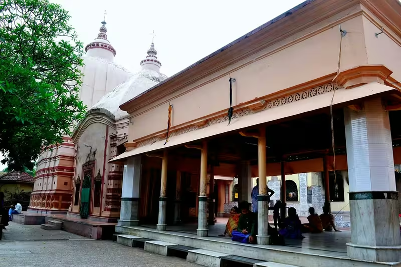
The modern Tamluk region retains important religious associations. Local tradition connects the Bargabhima Temple with Kalu Bhuiya, who is said to have established it approximately 1,150 years ago. The temple is identified in the tradition with one of the 51 Shakta Pithas. The Jishnu Hari Temple is likewise linked by local legend with the first king of the Tamluk dynasty. These accounts belong to the region's continuing historical memory, while their specific antiquity is not established by the evidence described here.
Political Significance and the Tamluk Raj
Little is known about the rulers and administration of ancient Tamralipta. Neither Fa-Hien nor Hiuen-Tsang provided a detailed account of the city's state organization. Literary works associate the city with Suhma and Vanga, but these references do not supply a continuous political history.
Much later traditions connect Tamluk with the Tamluk Raj family, also called the Tamralipta Royal Family. The family is described as approximately a thousand years old. Accounts of its social identity vary: some historians have suggested a Khandayat origin, while other traditions describe the ruling family as Kaibartta and state that its kings later identified as Mahishya.
The royal genealogy includes Kalu Bhuiyan, regarded as a founder of the Tamluk family around 900 CE. He is described as an administrator and military commander who conducted an Ashvamedha yajna and subdued neighbouring kingdoms. These accounts form part of the dynastic tradition surrounding Tamluk and should be distinguished from the better-attested archaeological history of the ancient port.
The connection between the ancient Tamralipta polity and the later royal lineage is also expressed through epic and historical tradition. The Rajatarangini is said to record that Tamradhwaja, son of Rajarshi Mayurdhwaja and ruler of the ancient Tamralipta kingdom, fought on the side of the Pandavas during the Kurukshetra war. Later interpretations identify Mayurdhwaja as the earliest known king of Tamralipta and associate the ruling line with the Mahishya community. Some traditions claim an exceptionally long continuity of Mahishya rule, extending from the period before the Mahabharata to the seventeenth century CE. This proposed continuity is a dynastic belief rather than a sequence securely demonstrated by surviving inscriptions.
The Tamluk Rajbari and Colonial Conflict
The later history of Tamluk was shaped by conflict with the East India Company and the British Raj. Rani Krishnapriya resisted the Company in 1781, but was ultimately defeated and deposed. The British confiscated her share after government officials attempting to execute a decree were resisted and seriously injured.
In 1789, Rani Krishnapriya died. In 1795, the entire zamindari was permanently settled with Ananda Narayan Roy. Tamluk was subsequently reduced to a small zamindari under British authority. The episode marked a major loss of political autonomy for the royal family.
The Tamluk Rajbari, or royal palace, is associated with both the family’s earlier status and its later anti-colonial activities. Raja Lakshminarayan Ray of the Mayur dynasty began construction in 1837, reportedly with an initial budget of two lakh rupees. The plan is said to have involved eight architects from Greece and European architectural features, including arches and a broad frontage. The central foundation and rows of rooms extending on both sides were constructed, and the arched rooms remain.
Construction was interrupted by a revenue dispute. Under the colonial “Sunset Law,” revenue had to be deposited by sunset on a specified day. Raja Lakshminarayan's soldiers carried the revenue towards Midnapore by river and land routes, but the money was looted by the British. Because the payment could not be made, much of the estate was auctioned. The Raja later appealed to the authorities at Fort William, pursuing the case to the Privy Council. Raja Narendranarayan later undertook work on the palace, but the building was not completed in the original form.
Tamluk and the Freedom Movement
The royal family's association with the freedom movement gave the Rajbari a new historical role. Many meetings connected with the Tamralipta Jatiya Sarkar in 1942 took place within the palace. After the organisation's downfall, British police subjected members of the royal family to severe brutality.
Raja Surendra Narayan Roy, described as the 60th ruler of the Tamluk royal family, supported several phases of the anti-colonial movement. He opposed the partition of Bengal in 1905 and later supported Deshapran Birendranath Sasmal during the Non-Cooperation movement. In 1920, he called for a boycott of foreign manufactured cloth.
During the Civil Disobedience Movement in 1930, he offered part of the Tamluk Rajbari to support Salt Satyagrahis. His activities helped create conditions in which leaders such as Sushil Kumar Dhara, Satish Chandra Samanta, and Ajoy Mukherjee became prominent. British authorities arrested him on 15 May 1930, but public protest led to his release on 22 May.
In 1938, Raja Surendra Narayan hosted a meeting for Subhas Chandra Bose, sacrificing his Khosarang mango orchard for the event. He also supported freedom fighters financially and through other assistance.
His son Dhirendra Narayan Roy participated in the Civil Disobedience Movement and was arrested several times. While studying medicine at Calcutta Medical College, he continued his political work and helped organize a public meeting for Subhas Chandra Bose in 1936, leading to another arrest. After his father's death in 1942, he became the king of Tamralipta but gave priority to India's independence rather than royal duties. After independence, he devoted himself to medical service and community welfare and served as a life member and officer of the World Doctors Association.
The state government now officially recognises the Tamluk Rajbari as a heritage site because of its architectural remains and connection with the freedom movement.
Archaeology and Monuments
Archaeology remains central to understanding Tamralipta because the written record leaves major gaps. Excavated pottery, terracotta figurines, coins, seals, ring wells, rammed floors, and a brick-built stepped tank reveal a settlement with long occupation and substantial infrastructure.
The Tamralipta museum preserves terracotta seals inscribed in the Kharoshthi-Brahmi script, dated to the early centuries of the Christian era. Their inscriptions and ship imagery contribute to the history of writing, trade, and maritime technology in eastern India. Coins and other artefacts from excavations in Birbhum and elsewhere provide additional evidence for regional networks.
Moghalmari is particularly important for the religious history of the area. Excavations there confirmed Buddhist viharas mentioned by Chinese travellers. The remains help connect the literary image of Tamralipta as a Buddhist port with physical evidence of monastic institutions in the surrounding region.
The Bargabhima Temple and Jishnu Hari Temple preserve other layers of Tamluk's heritage. Their histories are strongly shaped by local tradition and dynastic memory. The Tamluk Rajbari, meanwhile, represents the later political history of the town, from zamindari conflict to anti-colonial mobilisation.
Decline and Revival
Tamralipta's decline resulted from the interaction of environmental and human pressures. Political disorder, taxation, foreign attacks, and changing patterns of trade could weaken a port's commercial position. Yet the most decisive factor may have been the changing river system.
The Saraswati's eastward shift after about 700 CE separated its flow from the Rupnarayan connection that had supported Tamralipta. Sedimentation reduced the depth and usefulness of channels, while erosion and the movement of river outlets altered the coastline and waterways. As access changed, Saptagram became increasingly prominent.
The disappearance of Tamralipta as a major port did not erase the settlement. Tamluk remained a place of religious activity, dynastic memory, and regional identity. The modern revival of its public traditions includes the Tamralipta Janaswastha Krishi o Kutirshilpa Mela. Raja Lakshmi Narayan Roy is said to have begun the original fair around 973 years ago; it was later stopped during the British period and resumed in 1998 under its present name.
Modern Tamluk
Modern Tamluk preserves several overlapping histories. It is the town generally identified with ancient Tamralipta, the setting of the Tamluk Rajbari, a centre associated with temples and local traditions, and a place connected with the 1942 Tamralipta Jatiya Sarkar.
The ancient port itself cannot be understood simply as a surviving waterfront monument. River change, siltation, construction, and the transformation of the coastline have altered the landscape in which it once operated. Its history is reconstructed from scattered remains and references: a stepped tank, pottery, coins, seals, Buddhist remains, ship motifs, foreign coinage, and the accounts of travellers.
This fragmentary record is also what makes Tamralipta important. It shows how an ancient settlement could derive power from connections rather than from a single surviving palace or fort. Roads carried goods towards the major cities of the subcontinent, rivers brought inland commerce to the coast, and ships carried merchants, pilgrims, monks, and commodities across the Bay of Bengal.