Overview
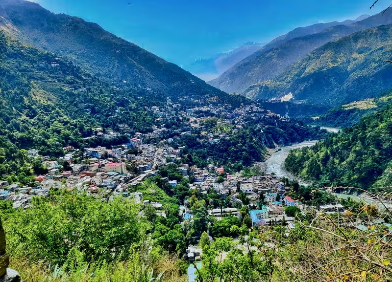
At an elevation of 1,006 metres, Chamba stands on successive terraces above the Ravi River, close to the point where the Sal River joins it. The town's setting is both scenic and strategic: the Ravi cuts through the surrounding mountains in deep canyons, while the Dhauladhar and Pir Panjal ranges enclose the wider landscape. On the eastern side, Shah Madar hill rises behind the town. This combination of river, terraces, steep slopes and forested hills helped shape Chamba's long history as a Himalayan capital.
The history of the town is inseparable from that of Chamba district. Regional traditions reach back to the Koli tribes of the 2nd century BCE and later refer to Khasas, Audumbaras, Thakurs, Ranas and Rajput rulers. The political story becomes more clearly defined around the figure of Maru, who is said to have moved into the region from Kalpagrama around 500 CE. His dynasty established its early capital at Brahmapura, later known as Bharmour. For roughly three centuries, the rulers governed from that upland centre.
The decisive change came in 920 CE, when Raja Sahil Varman transferred the capital to a more centrally placed plateau in the lower Ravi valley. The new capital was called Champavati, after his daughter Champavati, and the name gradually became Chamba. The town developed around temples, palaces, public grounds and administrative buildings. Its architecture records several stages of change: an early Rajput and Himalayan phase, a colonial phase after 1846, and a post-independence phase after the state's merger with India in 1948.
Chamba is remembered not only for its ruling dynasty and monuments but also for its living cultural traditions. The Suhi Mata Mela and Minjar Mela bring music, dance, processions and religious observance into the centre of town. Chamba rumals, shawls, metalwork, wood carving, traditional instruments and Pahari paintings connect the present town with the artistic world of its former court. The result is a place where political history, sacred traditions, crafts and mountain geography remain closely linked.
Etymology and Names
The earlier capital associated with the Maru dynasty was called Brahmapura. In later usage it became Bharmour, the name by which the historic upland town is known today. Bharmour lies in the wider Chamba region and is described as being approximately 65 to 75 kilometres from present-day Chamba, depending on the account.
The modern town's traditional name is linked to Champavati, the daughter of Raja Sahil Varman. When the king shifted his capital from Bharmour to the lower Ravi valley in 920 CE, the new settlement was called Champavati. Over time, the name was shortened to Champa and then to Chamba.
Historical accounts preserve more than one explanation for this naming. In one version, Champavati herself urged her father to establish a capital in the valley. The king had previously granted land in the area to Kanwan Brahmins, and the land was obtained through an agreement involving a gift of eight copper coins, called chaklis, at each marriage in the Brahmin family. The new capital was then built on the acquired land.
Another account presents the origin as a religious story. Champavati is said to have regularly visited a hermitage. Her father became suspicious of her conduct and followed her there, but found neither his daughter nor the hermit. A voice then told him that Champavati had been taken from him because of his distrust. The chastened king is said to have expanded the hermitage into a temple and founded a city around it. The temple became known as the Champavati Temple, and Champavati came to be venerated as a goddess.
These accounts belong to the traditional history of Chamba and differ in detail. Together, they explain why the town's foundation, name and sacred landscape are so closely associated with Champavati.
Geography and Location
Chamba lies in the lower Ravi valley of Himachal Pradesh. The town is built on the right bank of the Ravi, near the confluence of the Ravi and the Sal. The river flows broadly from east to west through deep canyons. During spring and summer, snowmelt raises the water level considerably. This creates a seasonal risk of flooding. In early July 2005, river levels reached such heights that the National Hydroelectric Power Corporation had to shut down generation at the 300-megawatt Chamera Power Station.
The town's terraces form a natural sequence of level surfaces in an otherwise steep mountain environment. This topography influenced both the location of the old settlement and the later design of public spaces. The historic temples and palaces were concentrated east of the Chaugan, on the lower slopes of Shah Madar hill. The two rivers and steep, densely forested hillsides offered protection, making the area suitable for a capital whose rulers depended on the defensive advantages of the landscape.
Chamba is bordered by a broad network of mountain and foothill regions. Kishtwar and Doda lie to the north-west in the Jammu region. Ladakh, Lahaul and Bara Banghal are to the north-east and east, Kangra lies to the south-east, and Pathankot district of Punjab is to the south. These connections placed Chamba between the high Himalaya, the western hill states and the plains.
Despite its mountainous setting, Chamba is connected by road with other parts of Himachal Pradesh and with cities including Shimla, Delhi and Chandigarh. The nearest broad-gauge railway stations are at Chakki Bank and Pathankot. Pathankot is approximately 120 kilometres from Chamba by road.
The town has warm summers and cold winters. Summer temperatures generally range from 15°C to 38°C, while winter temperatures range from 0°C to 15°C. The recorded maximum summer temperature is 40.6°C and the recorded minimum winter temperature is −1°C. Annual rainfall averages 785.84 millimetres. March to June is traditionally regarded as a favourable period for visiting the town.
The wider district contains several protected wildlife areas, including the Gamgul Siyabehi Wildlife Sanctuary, Kalatop Khajjiar Wildlife Sanctuary, Kugti Wildlife Sanctuary, Sechu Tuan Nala Wildlife Sanctuary and Tundah Wildlife Sanctuary. These sanctuaries show that Chamba's historical landscape extends well beyond the urban centre into high-altitude valleys, forests and mountain habitats.
Ancient and Early History
The earliest political history of the Chamba region is layered rather than continuous. Traditions associate the area with Koli tribes in the 2nd century BCE. Later, the Khasas and Audumbaras are described as powerful in the region. During the Gupta period, the area was ruled by Thakurs and Ranas. From the 7th century, Gurjara-Pratihara or Rajput rulers are said to have come to power.
These successive groups indicate that the region was connected to wider political currents while retaining a strong local character. Mountain geography encouraged the survival of local ruling units, and the valley systems made political authority uneven. Before the reign of Raja Sahil Varman, the territory later identified as Chamba was not a fully consolidated state. Local Ranas governed separate areas that functioned almost as independent fiefdoms.
The Rajput tradition of Chamba is traced to Maru. He is said to have come from Kalpagrama to north-western India around 500 CE. In the Budhal River valley he founded a capital called Brahmapura. This settlement later became Bharmour. The early kingdom therefore developed in an upland valley east of the present town rather than on the lower Ravi terraces where Chamba now stands.
For about three hundred years, the Rajput rulers governed from Bharmour. The setting was remote and mountainous, and the political territory remained loosely defined. The importance of Bharmour lies in its role as the first major capital of the dynasty that later established Chamba.
Historical Timeline
The Bharmour Capital
Maru's establishment of Brahmapura around 500 CE marks the beginning of the recorded Rajput tradition of Chamba. The town later called Bharmour served as the dynastic capital for approximately three centuries. During this time, the ruling family developed authority over a collection of local territories rather than a fully unified administrative state.
The early political system was characterised by Ranas and petty rulers controlling local fiefdoms. These rulers exercised considerable autonomy. Their territories were connected to the larger Rajput kingdom but were not yet completely subordinated to a single central authority.
The Transfer to Champavati
Raja Sahil Varman's reign brought a major transformation. In 920 CE, he transferred the capital from Bharmour to a lower and more centrally located plateau in the Ravi valley. The new city, Champavati, was named after his daughter.
The transfer was more than a change of residence. It marked the development of a new political centre in a location with access to the lower valley and stronger connections across the surrounding territory. During Sahil Varman's reign, the local Ranas were brought under firmer control, and Chamba district was consolidated as a unified entity.
The foundation traditions also associate Sahil Varman with the Champavati Temple and with the early history of the Lakshmi Narayan temple complex. These monuments helped give the new capital a sacred and political identity.
The Medieval Kingdom
The dynasty that ruled from Chamba is said to have produced 67 rajas from the time of Maru until the state's merger with India. The town's isolation and rugged terrain are traditionally regarded as major reasons for its unusual political continuity. The kingdom remained independent of successful foreign conquest for centuries, although it encountered pressure and attempted intervention from larger powers.
The Mughal emperors Akbar and Aurangzeb are said to have attempted to annex Chamba but did not succeed in subjugating it. The kingdom nevertheless interacted with the Mughal world. Raja Prithvi Singh, who ruled from 1641 to 1664, maintained friendly relations with Emperor Shah Jahan. His court is associated with the introduction of Mughal-influenced lifestyles into Chamba.
The Lakshmi Narayan temple complex also reflects this period's political pressures. In 1678, Raja Chhatra Singh adorned the temple roof with gold-plated pinnacles in response to Aurangzeb's order for the demolition of the temple. The episode illustrates the way royal patronage, religious architecture and imperial politics were connected in the town.
The Gurkha Campaign and Sikh Influence
In 1806, Gurkha forces and local hill chiefs attacked the forces of Raja Sansar Chand. Sansar Chand suffered a severe defeat and, with his family, took refuge in Kangra Fort. The Gurkhas besieged the fort and devastated the area between Kangra Fort and Mahal Mohrian. Villages were extensively looted or destroyed, and the siege continued for three years.
In 1809, Raja Ranjit Singh of Lahore intervened at Sansar Chand's request. His forces defeated the Gurkhas, but Sansar Chand had to surrender Kangra Fort and 66 villages to the Sikhs. Ranjit Singh then controlled the wider region, placed a garrison at Chamba and required the hill states to pay tribute.
Chamba received different treatment from the more powerful Kangra state. The Wazir Nathu of Chamba had played an important role as an ambassador during the negotiations with the Katoch ruler in 1809. He is also said to have saved Ranjit Singh's life during a winter campaign in Kashmir in 1817 by giving up his horse so that the Sikh ruler could escape. These actions helped Chamba retain its ruling house even as Sikh power expanded across the hill states.
British Suzerainty
In 1845, the Sikh army invaded British territory. The British defeated the army, leaving Chamba in a vulnerable political position. Wazir Bagha of Chamba took part in the negotiations that followed. On his advice, the Rajas of Chamba accepted British suzerainty as part of the arrangements connected with Jammu and Kashmir, in return for an annuity of 12,000 rupees.
The Treaty of Lahore was signed in 1846. Under its terms, the Rajas agreed to cede the territory of Chamba district. From this point, Chamba's relations with British officials were described as cordial. The rulers Sri Singh, Gopal Singh, Sham Singh, Bhuri Singh, Ram Singh and Laxman Singh maintained good relations with British army officers.
British influence brought changes to administration, transport, education, health and architecture. These changes did not erase the older town. Instead, a new civic landscape developed around the Chaugan, alongside the earlier temples and palaces.
Colonial Development
The first post office in Chamba was established in 1863, together with a daily mail service. A primary school was also established that year. In December 1866, Doctor Elmslie of the Kashmir Medical Mission opened a hospital. During the late 1860s, new roads connected Chamba with Dalhousie through Kolri and Khajiar.
Gopal Singh, who ruled from 1870 to 1873, was associated with the construction of the Jandarighat Palace as a summer residence after his abdication. Under Major Blair Reid, who arrived in January 1863, the town underwent a particularly active period of administrative and urban development. Reid revised the revenue and administrative departments and reorganised the state machinery.
Road communications improved dramatically. The approach road to the town was diverted so that vehicles could enter from the western end of the Chaugan. A suspension bridge using cables was built across the Ravi in the lower outskirts of the town. Between 1863 and 1910, the state also saw the construction of public welfare facilities, temples, gates, gardens and churches.
Integration with India
India became independent in August 1947. Chamba remained a princely state for a short period afterward. On 15 April 1948, it merged with the Indian Union along with Mandi-Suket, Sirmour and the other princely states of the Shimla hills. This ended the political existence of the Chamba princely state, but the town continued as the administrative headquarters of Chamba district.
Political Significance
Chamba's political importance rests on the continuity of its ruling house and the strategic role of its capital. The move from Bharmour to Champavati created a more central base in the lower Ravi valley. The town's terraces provided space for royal, religious and administrative buildings, while its surrounding slopes created natural protection.
Before Sahil Varman, political authority was divided among Ranas and local rulers. The king's consolidation of these territories transformed a loosely organised region into a more unified state. The five later administrative divisions of the Chamba kingdom were Chamba, Bharmour, Bhatti, Churah and Pangi. These units were first known as mandalas and later as wazarats.
The royal capital was therefore both a residence and an administrative centre. Palaces overlooked the principal public ground, temples expressed the religious responsibilities of the dynasty, and later British-era buildings reorganised civic life around the Chaugan. The town's built environment preserves these political layers.
Chamba's independence was never absolute in the sense of isolation from surrounding powers. It maintained relationships with Mughal emperors, encountered Sikh expansion and eventually accepted British suzerainty. Yet the ruling family continued in place through these changes. The kingdom's survival was aided by its location, its rugged terrain and its diplomatic relationships.
The negotiations of 1846 demonstrate the importance of political intermediaries. Wazir Bagha's role helped determine the terms under which Chamba entered the British imperial system. The earlier diplomacy of Wazir Nathu had similarly protected Chamba during the period of Sikh expansion. Political survival depended not only on mountain defences but also on negotiation.
Religious and Cultural Importance
The religious landscape of Chamba is concentrated in the old town, especially on the lower slopes of Shah Madar hill and around the Chaugan. Temples built between the 10th and 19th centuries include the Champavati Temple, the Lakshmi Narayan group, the Sita Ram Temple, the Bansi Gopal Temple, the Hari Rai Temple, the Sui Mata Temple and the Chamunda Devi Temple.
The temples demonstrate a strong Kashmiri influence in their stone construction and iconography. Because of their age, some have retained mainly their unicellular layouts and fluted pillars. Their forms reflect the architectural world of the western Himalaya, where stone and wood were combined to respond to climate, terrain and seismic conditions.
Champavati Temple
The Champavati Temple is associated with the foundation of the town. Raja Sahil Varman is said to have built it in memory of his daughter Champavati. Located near the Police Post and Treasury building, it is constructed in the shikhara style and contains intricate stone carvings. The temple has a wheel roof and is comparable in scale to the Lakshmi Narayan Temple.
The principal image worshipped there is Mahishasuramardini, an aspect of the goddess Durga. Stone sculptures cover the temple walls. The monument's historical and archaeological importance has led to its maintenance by the Archaeological Survey of India.
The temple's foundation legend explains the relationship between royal authority, moral responsibility and sacred architecture. In the story, the king's suspicion of his daughter leads to her disappearance and to his instruction to build a temple in her name. Whether read as a religious narrative or as part of Chamba's traditional historical memory, the story makes Champavati central to the identity of the city.
Lakshmi Narayan Temples
The Lakshmi Narayan complex is devoted to the Vaishnavite tradition. The principal temple was built in the 10th century by Raja Sahil Varman. It includes a sanctum sanctorum, or garbhagriha, an antarala and a mandapa. The building has a shikhara and wooden chhatris adapted to the local climate.
At the entrance, a metallic image of Garuda, the mount of Vishnu, stands on a dhwajastambha pillar. The temple roof was decorated with gold-plated pinnacles by Raja Chhatra Singh in 1678. This act is traditionally understood as a response to Aurangzeb's order to demolish the temple.
The complex shows how a temple could function as a religious institution, a royal monument and a statement of political confidence. Its long history also demonstrates the continuity of sacred architecture through changing political circumstances.
Sui Mata Temple and the Suhi Mata Mela
The Sui Mata Temple commemorates a queen associated with the history of Chamba's water supply. According to the traditional account, a dream or prophecy declared that water from the Sarota stream could reach the town through an aqueduct only if the queen or her son were sacrificed. The queen chose to give her own life rather than allow her son to be killed.
The annual Suhi Mata Mela takes place in March or April and lasts four days. Women and children play the leading role. An image of Champavati, accompanied by banners bearing the Rajput solar emblem, is carried in procession through the Chaugan to the Sui Mata Temple. Participants sing and dance as part of the commemoration.
The festival gives public form to a story of sacrifice, water and the welfare of the town. It also places women and children at the centre of a major civic and religious event.
Chamunda Devi Temple
The Chamunda Devi Temple occupies a prominent position on a spur of the Shah Madar range opposite Chamba. Raja Umed Singh built it, and it was completed in 1762. Unlike the stone Nagara-style temples elsewhere in the town, it is a wooden, single-storeyed structure with a gabled roof.
The temple stands on a raised plinth buttressed on all four sides. Its outer rectangular structure measures 9.22 by 6 metres. The inner square sanctum measures 3.55 by 3.55 metres and is surrounded by a circumambulatory path. A mandapa in front measures 5.1 by 6 metres and contains a central fire pit.
The mandapa has a slate-covered gable roof, a multi-panelled wooden ceiling and carved reliefs of human figures on pillars and brackets. Votive bells hang near the entrance. A Nagari inscription records an offering by Pandit Vidhadhara and gives the consecration date as 2 April 1762.
The temple was once reached by a steep stone path of 378 steps. It can now be approached by a motorable road approximately three kilometres long.
The Minjar Mela
The Minjar Mela is one of Chamba's best-known public festivals. It takes place on the second Sunday of the month of Shravana, usually corresponding to August. The festival marks the victory of the Raja of Chamba over the ruler of Trigarta, identified with present-day Kangra, in 935 CE. It also celebrates the paddy and maize crops of the season.
The name refers to the minjar offering: a bunch of paddy and golden silk wrapped in red cloth. The offering is accompanied by a rupee, seasonal fruit and a coconut. A flag-hoisting ceremony at the Chaugan opens a week of cultural and social programmes.
The image of Lord Raghuvira and more than 200 other deities are carried in a chariot pulled by ropes. Folk music and dances, including Kunjari Malhar, form part of the celebration. On the final day, a procession travels from the Akhand Chandi Palace to the Ravi, where offerings are made to the river.
The river ceremony is associated with a tradition that Raja Sahil Varman altered the course of the Ravi so that the Hari Rai Temple would be accessible to all devotees. The Minjar Mela therefore combines royal memory, agricultural celebration, temple worship and the sacred geography of the river.
Economic Role and Craft Traditions
Chamba's economy has long been connected to its position between the mountain interior and the lower regions. The town's artisans produced objects for temples, courts, households and ritual occasions. The aristocratic background of the former kingdom is visible in the refinement of many surviving crafts.
Metalworking is an old tradition. Artisans cast copper, brass and iron objects, including implements, weapons and large decorative plaques with relief designs. Copper and brass objects were used on temple cupolas, while golden kalashas or vessels crowning temples were also produced in the region.
Wood carving served both architectural and religious purposes. Carved wooden elements were used in temples such as Chamunda Devi, while traditional houses also depended heavily on timber. Chamba artisans made footwear, jewellery, pottery, textiles, musical instruments and household goods.
Traditional footwear was once made from local leather, although leather is now transported to Chamba from southern India. Women's footwear is embroidered. There is also a deliberately non-leather form of “vegetarian” footwear for use in contexts where leather is religiously prohibited.
Handkerchiefs and shawls were traditionally hand-spun and embroidered so that both sides of the cloth appeared identical. The embroidered Chamba rumal is particularly associated with the region. Chamba shawls are woven on handlooms in wool and usually feature a bright traditional border. Similar woven designs are used for caps.
Jewellery is made in gold and silver. Chamba's history of migration from Kashmir, Tibet and other regions has contributed to varied designs and influences. Potters produce kitchenware, utensils and earthen vessels.
The town also produces a wide range of traditional musical instruments. These include the nagara or kettle drum, cymbals, bells, and the straight or curved singa and ransinga horns. Other instruments named in the musical tradition of Chamba include the shankh, nad, beiunsuli, saihna, nag pheni, thali ghada, bhana, karnal, pohol, dhons, kahal, kansi, hasat ghanta and drugg.
Pahari Painting and the Bhuri Singh Museum
Chamba is associated with the Pahari miniature painting tradition that developed in the hill kingdoms of northern India between the 17th and 19th centuries. The Basohli style took root in Chamba after Nikku, a Basohli artist, moved from Guler to the town in the 18th century.
Raja Udai Singh and Raja Jai Singh patronised the Chamba school. During the reign of Raja Charhat Singh, folk art developed in ways that continued to influence local artists. Mughal influence can be seen in the paintings, even when the subjects are drawn from Hindu religious stories or local culture.
Themes include Radha and Krishna, Shiva and Parvati, Rama's court, Yashoda and Krishna, the gopis, romantic scenes, birds, deer and women. The Daya Saptashati and Krishna-Sudama are also represented. Artists painted the atmosphere of the monsoon, including the emotional moods associated with rain, separation and romance.
Artists associated with Chamba include Lehru, Durga and Miyan Jara Singh. Works connected with the tradition are displayed in the museums of Chamba, Shimla and Dharamsala.
The Bhuri Singh Museum was founded on 14 September 1908 in honour of Raja Bhuri Singh, who ruled from 1904 to 1919. The indologist J. Ph. Vogel proposed the museum as a place to preserve inscriptions, many written in the Sarda script, that recorded aspects of Chamba's medieval history.
The museum preserves the prashastis of Sarahan and Devi-ri-kothi and the Mul Kihar fountain inscription. Raja Bhuri Singh donated his family collection of paintings, including royal portraits ranging from the Basohli to the Guler-Kangra styles. Other collections include embroidered Pahari miniatures, coins, hill jewellery, royal and traditional costumes, arms and armour, musical instruments and other heritage objects.
The present museum building was constructed in concrete in 1975. Its collections provide a direct connection between Chamba's political history and its artistic traditions. Inscriptions record royal and local memory; paintings reveal courtly patronage; costumes and jewellery show social identity; and instruments preserve the sound-world of festivals and ceremonies.
Domestic Architecture and the Old Town
Before the British period, houses in Chamba were built from locally available materials. Walls used dry stone masonry. Older walls and floors were plastered with a mixture of clay and cow dung. Thick wooden beams supported the buildings and helped them withstand earthquakes. Wooden cantilevers often supported verandas.
Staircases and doors were made of wood. Doors were frequently decorated with religious reliefs and flanked by lamps that could be lit at night. Before slate roofs became common under British influence, roofs were covered with planks and coated in clay. Some village houses in the suburbs still preserve wood-and-clay roofs.
The old town is distinct from the later British zone. Its temples, palaces and residential buildings occupy the lower valley and the slopes east of the Chaugan. The historic layout reflects the needs of a mountain capital: defensible terrain, proximity to the river and concentration of royal and sacred buildings.
A study of Chamba's urban evolution identifies three phases. The first began in 930, after the Rajput dynasty established the capital, and lasted until 1846. The second was the British period. The third began after the state merged with India in April 1948. Each phase introduced new building forms while leaving older layers in place.
Akhand Chandi Palace
The Akhand Chandi Palace overlooks the Chaugan and is recognised by its distinctive green roof. Raja Umed Singh built it between 1747 and 1765 as a royal residence. Raja Sham Singh later refurbished it with the assistance of British engineers.
In 1879, the Darbar Hall was constructed. It was also called Marshal Hall after its builder. Raja Bhuri Singh added the Zenana Mahal for the royal women. The palace consequently became a record of changing courtly needs and architectural influences.
Its design combines Mughal and British elements. Painted walls, glasswork and intricate woodwork formed part of its decoration. From the palace, views extend over the Chaugan and several major monuments, including the Lakshmi Narayan, Sui Mata, Chamunda Devi, Rang Mahal, Hari Rai and Bansi Gopal temples.
In 1973, the royal family sold the palace to the Government of Himachal Pradesh. It was converted into a government college and district library. The building's maintenance has been difficult because of limited funds for restoration. Its condition illustrates the challenge of preserving large historic structures after their original royal functions have ended.
The British Civic Landscape
British planners focused on the area around the Chaugan. The purpose was partly to create an orderly civic centre that would contrast with the irregular structure of the older residential quarters. New buildings had white plastered walls, lancer-arch windows, cornices, sloping sheet roofs, wooden eaves and deep verandas.
Important colonial-period buildings and spaces include the temples in Jansali Bazar, Gandhi Gate or Curzon Gate, the Shiva Temple, the Chaugans, Police Lines, the Church of Scotland, Shyam Singh Hospital, Chamba Library, the Post Office, Bhuri Singh Museum, state forces barracks and administrative offices.
The Church of Scotland, also known as St Andrew's Church, is associated with the Reverend William Ferguson, the first missionary in Chamba, who served from 1863 to 1873. The foundation stone of the present church was laid on 17 February 1899 by the Raja of Chamba in the presence of Dr M'Clymont, a Scottish reverend. The Raja contributed a grant for the building.
Constructed in fine stone masonry, the church has buttressed walls and lancer-arch windows. Schools run by the mission are located within the church precincts. Its presence reflects the religious and educational institutions that formed part of the colonial town.
The Chaugan
The Chaugan is the central public ground of Chamba. The name comes from a Sanskrit word meaning “four-sided.” It is surrounded by administrative buildings and a shopping arcade constructed during the British period, while the Akhand Chandi Palace stands nearby.
The Chaugan is unusually large for a hill town. It measures approximately 800 metres in length and 80 metres in width. In 1890, the British joined five smaller chaugans to create a single esplanade and sports complex.
Today the ground is used for cricket, picnics and promenades during the summer. During the Minjar Mela, it becomes a large open-air market. The Chaugan is therefore both a planned colonial space and a continuing centre of public life.
After the Dussehra festival, the grounds are closed until April for maintenance. Its seasonal cycle demonstrates how an urban space can serve different functions: recreation, commerce, ritual procession and civic gathering.
Communities, Languages and Social Life
In the 2001 census, Chamba recorded a population of 20,312. Males constituted 52 percent and females 48 percent. The literacy rate was 81 percent, with male literacy at 85 percent and female literacy at 77 percent. Hindi is the administrative language, while Chambeali is spoken locally. Punjabi and Pashto are also spoken by some residents, including communities of Sikh and Hindu background who came to the area after the Partition of 1947.
The wider Chamba district is home to communities popularly known as Chambials. Two major groups described in the regional account are Gujjars and Gaddis.
The Gujjars are mainly nomadic pastoralists who came to Chamba across the border from Jammu and Kashmir along trade routes. Many belong to the Muslim community. In autumn, they move with their livestock towards the lowland Punjab to avoid the harsh winter of the Chamba hills. They speak Gojri and maintain a distinct culture from the main town.
The Gaddis include Brahmans, Rajputs, Thakurs, Rathis and Khatris, with the Khatris described as the majority in the account. They are agricultural people, although the word Gaddi is associated with shepherding. They mainly inhabit the Dhaula Dhar region of Chamba district, known as Brahmaur Wazarat or Gadaran, between Chamba and Kangra.
The word Gadar means sheep, so Gadaran may be understood as “sheep country.” Gaddi communities are traditionally believed to have arrived in Chamba in the 10th century. Another migration is associated with Lahore in the 18th century, during the Mughal period. Their religious practice is described as combining animism with the worship of Shiva.
Festivals, Music and Dance
Fairs in Chamba are not simply annual markets. They connect royal history, agricultural cycles, temple traditions, local deities and community performance. At some fairs, a chela, or subordinate of a deity, enters a trance and answers the questions and prayers of devotees.
Devotional songs called Ainchali are sung through the night. During these ceremonies, the chela is summoned and may enter a trance when sacrifices to Shiva are discussed. The possessed figure is understood by participants to embody the presence of the deity and responds to questions from families and friends.
Chamba's folk music includes songs for marriage, festivals and love. Marriage songs, called Charlai, concern the selection of a groom and the wishes of the bride. They are also sung during the wedding ceremony as relatives of the bride and groom seek divine blessings.
Festival songs accompany fairs and dances. Sukart and Ghanihar are associated with the Minjar Mela. Kunjari Malhar is performed during the same festival. Songs connected to Baisakhi are sung at Basoa, while Kunjadi songs of the rainy season are associated with the Patroru festival.
Love songs often express separation, hardship, social restrictions, sacrifice and unsuccessful love. Popular narratives include Kunju and Chanchlo, Phulmu and Ranjhu, Raja Gaddan and Bhunku Gaddi. These songs are enjoyed in both Chamba town and the wider state.
The region's dances show differences in geography, community and belief. Pharati and Khad-dumbi may be performed by one or two people during the Nuwala ceremony, marriages and other important occasions. Other dances include Dangri, Sikri, Gaddi, Gujjar, Dandaras, Nat, Ghorda, Nachan, Dharumsde and Chhinjhati.
Women's dances include Ghurei, Dangi and Kikli. Both men and women perform Shain, Dhamal, Sohal, Sal Kukdi Nachan, Ratege and Til-Chauti. Masked dances such as Chhatradhi Jatar are also performed.
Clothing and Textiles
Chamba's cold climate encouraged the use of woollen clothing. Earlier inhabitants are described as wearing a fine woollen blanket or chadar around the waist, secured by a band or patka. Archaeological discoveries and representations from the region preserve evidence of this style.
Gaddi people traditionally wear white embroidered caps and loose white woollen garments called cholas. These are tied around the waist with a black wool rope. During the Nuwala ceremony for Shiva, a local custom involved giving a cotton maikhal sheet to a Jogi of the Natha sect to wear over the head.
Chamba has been known for fine cloth and embroidered dresses for centuries. References to beautifully embroidered Kotumbara clothing from the Audumbara country connect the region around Pathankot and Chamba with an older textile tradition. Heavier embroidered garments are represented on fountain stones erected by local aristocrats in western Chamba in the 11th and 12th centuries.
Hindu women traditionally wear the pashwaj on special occasions. It consists of a short bodice reaching the waist and a long, many-folded dress. Everyday clothing may include a pairahan, a chadar or dupatta worn over the head, and a suthan covering the lower body.
Muslim women wear comparable garments, although the tunic is generally shorter and reaches the knee. An angi may be worn beneath the bodice, along with a small shirt or kurta.
Hindu men's traditional dress includes the angrakha, a long tunic reaching the knees, a cloth waistband, fitted pyjamas and a small pagri or top hat. These clothes, like the region's music and crafts, reflect both environmental adaptation and the cultural diversity of the Chamba area.
Decline, Transformation and Revival
Chamba did not experience a single dramatic decline. Its political role changed gradually as outside powers became more influential. The arrival of Sikh power in the early 19th century, British suzerainty after 1846 and integration with India in 1948 each altered the position of the ruling family and the administration of the town.
The end of princely rule did not erase the urban landscape created by the dynasty. Palaces became public institutions, temples continued as places of worship, and the Chaugan remained a civic centre. The Akhand Chandi Palace's conversion into a college and district library illustrates this transformation.
The British period introduced postal services, roads, bridges, hospitals, schools and new forms of civic architecture. After independence, reinforced concrete construction began to change the skyline. Modern development has therefore added another layer to the older town.
Preservation remains a concern. The Akhand Chandi Palace, with its painted walls, glasswork and woodwork, has suffered from inadequate maintenance. The work of the Bhuri Singh Museum and the Archaeological Survey of India at the Champavati Temple shows the importance of institutions in protecting Chamba's material heritage.
The town's festivals, crafts, music and religious processions provide a form of cultural continuity that does not depend only on preserved buildings. Chamba's heritage survives through both monuments and practice.
Modern Chamba
Chamba is the administrative headquarters of Chamba district and remains a compact Himalayan town shaped by its historic geography. The Ravi and Sal rivers, Shah Madar hill, the Chaugan and the old temple quarter continue to define its identity.
Visitors encounter several overlapping urban zones. The old town contains the principal medieval and early modern temples and palaces. The British quarter surrounds the Chaugan with civic buildings, public institutions and the shopping arcade. Newer construction, including reinforced concrete buildings, is gradually changing the skyline.
The town's principal heritage attractions include the Champavati Temple, Lakshmi Narayan temples, Sui Mata Temple, Chamunda Devi Temple, Akhand Chandi Palace, Church of Scotland and Bhuri Singh Museum. The Chaugan provides the central open space for festivals, sport and public gatherings.
Chamba is also a base for understanding the wider district. The mountain communities of the Gaddis and Gujjars, the protected wildlife sanctuaries and the routes towards Bharmour, Kangra, Pathankot and the high Himalayan valleys all belong to the larger historical and cultural setting of the town.
Its cultural importance rests on the combination of royal memory, sacred architecture, artistic production and living festivals. The town's history is not confined to a palace or a single temple. It is distributed across the valley, the river, the public ground, the workshops, the museum and the annual ceremonies that bring the historic centre back to life.