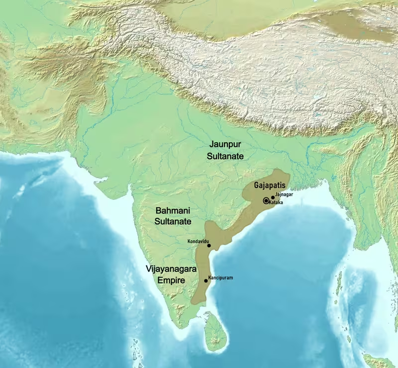
Gajapati Empire at Its Height, c.1464
Introduction
From the Ganges near Hooghly to the Kaveri and Tiruchirappalli, the Gajapati Empire reached its widest recorded extent in the 15th century. Centred on Odisha and ruled from Kataka, identified with Cuttack, it controlled or claimed a long stretch of eastern and southern India during the reign of Kapilendra Deva. This map focuses on that moment of expansion and on the political, military, and religious networks that connected the imperial heartland with distant frontiers.
The Gajapati monarchy ruled from approximately 1434 to 1541 CE. It succeeded the Eastern Gangas after the death of Bhanu Deva IV and was founded by Kapilendra Deva of the Suryavamsa lineage. The empire’s boundaries were not permanently fixed: southern possessions were later lost to the Vijayanagara Empire and the Golconda Sultanate, while the religious authority of Jagannath and the political traditions of Odisha remained influential long after territorial contraction.
Historical Context
The Gajapatis inherited the political and military foundations of the Eastern Ganga kingdom. Kalinga, corresponding broadly to present-day Odisha, had been ruled by the Eastern Gangas, whose early capital was Kalinga-nagara, identified with Mukhalingam near Srikakulam in present-day Andhra Pradesh. In the 13th century, the Gangas shifted their capital to Cuttack. Their legacy included powerful kingship, temple patronage, and an organised military system that the Gajapatis developed further.
Kapilendra Deva established the Gajapati monarchy after the end of Eastern Ganga rule. Under his leadership, the kingdom became a military state whose expansion depended on the emperor, the population, local military groups, and tributary rulers. By the height of Gajapati power in the 15th century, the imperial sphere extended northward to the Ganges near Hooghly and southward to the Kaveri and Tiruchirappalli.
The map’s most expansive configuration belongs especially to the period associated with Kapilendra Deva. By the early 16th century, however, the southern dominion had been reduced. The Vijayanagara Empire and the Golconda Sultanate took substantial territories previously held by the Gajapatis. The reign of Prataparudra was also shaped by the influence of Chaitanya Mahaprabhu, who lived at Puri for 18 years. Prataparudra’s increasing religious involvement and retirement to an ascetic life left the succession vulnerable. Govinda Vidyadhara subsequently assassinated the emperor’s sons and seized power.
Territorial Extent and Boundaries
The northern limit shown on this map is the Ganges near Hooghly. The southern limit at the empire’s maximum extent is associated with the Kaveri and Tiruchirappalli in modern Tamil Nadu. These points describe the broadest imperial reach rather than a single uniformly administered province. The surviving historical record distinguishes between the core kingdom, territories under military authority, and tributary states that supplied troops when required.
The eastern side of the empire was oriented toward the Bay of Bengal. The principal political heartland lay in Odisha, while the imperial sphere extended along the eastern coast into areas corresponding to present-day West Bengal, Andhra Pradesh, and Tamil Nadu. The Godavari appears in accounts of Gajapati military operations and encampments, marking a significant geographical zone in the southern and eastern theatre.
The western frontier is less precisely defined in the available record. The empire’s political identity was rooted in the coastal and inland regions of Kalinga and Odisha, but the historical description does not establish a single continuous western boundary. A careful reading of the map should therefore treat the outermost shaded area as an imperial reach or sphere of authority rather than assuming equal levels of direct control everywhere.
The Kolleru Lake region preserves a military tradition connected with Langula Narasimha Deva. According to the legend, a Gajapati fort stood at Kolleti Kota on one of the lake’s eastern islands. An opposing commander camped at Chiguru Kota and attempted to excavate a channel at the modern Upputeru so that the lake would drain into the sea, allowing an attack on the fort. This account combines geography, fortification, and military strategy, although the precise historical details of the tradition should be treated cautiously.
Administrative Structure
Kataka, or Cuttack, was the Gajapati capital. It was the centre from which the monarchy coordinated administration, military mobilisation, and the defence of captured territory. The empire was organised along strongly military lines. Protection and expansion were considered responsibilities of both the state and the population, while feudal tributary states were expected to provide a stipulated number of soldiers in wartime.
The army included a large standing force, local military groups, and contingents supplied by subordinate rulers. Officers held titles such as Senapati, Champati, Routray, Paikaray, Sahani, Dandanayaka, Gadanayaka, Nayaka, and Pattanayaka. The titles indicate differentiated responsibilities, including command of cavalry, elephant forces, marches, forts, and captured territories.
The military divisions described in Odia literary material included forward scouts, advance units, attack groups, archers, cavalry, elephant corps, rear guards, royal bodyguards, and detachments left in charge of forts. The Paridhana division was associated with commanding officers and fort duty, while the Prahari served as guards and military police. These arrangements suggest that conquest was followed by the placement of officers and troops in strategic settlements and fortifications.
Infantry organisation was also formalised. A Dala consisted of 27 Paikas under a Dalabehera. A Bhuiyan consisted of 70 Paikas and was commanded by a Paikaray. Several Bhuiyan units formed a Vahini, and multiple Vahinis formed a Chamu or regiment under a Chamupati or Champati. This structure linked local military service with larger imperial formations.
Infrastructure and Communications
The surviving descriptions provide more information about military movement than about civilian roads, postal institutions, or commercial infrastructure. The Hantakaru Dala marched at the front of the army, undertaking forward scouting, clearing jungles, and marking roads. Its role resembles that of an engineering and route-preparation division. The Aguani Thata followed as an advance formation, while the main force and rear divisions protected the army’s movement.
Military music helped coordinate and motivate troops. Instruments included the Damalu, Damame, Tamaka, Bizighosa, Daundi, Ghumura, Bheri, Turi, and Ranasingha. The Itakara division carried instruments and performed music and dance during wartime, reporting to the officer responsible for non-combatants.
The record does not provide a mapped postal system or a detailed network of commercial highways. It does, however, show that military communication depended on organised marching divisions, officers, guards, and fort commanders. The empire’s long coastal reach and its campaigns across river valleys required the movement of infantry, cavalry, elephants, supplies, and siege equipment over varied terrain.
Economic Geography
The available historical description does not identify a complete list of markets, ports, commodities, or agricultural districts. It is therefore not possible to reconstruct a detailed trade map from the record presented here. The empire’s geography nevertheless included fertile coastal and riverine zones, particularly around Odisha and the major river systems associated with its eastern and southern territories.
Kataka’s position made it a political and military centre, while Puri functioned as the principal religious centre of the Jagannath tradition. The broad coastal orientation of the kingdom connected Odisha with the Bay of Bengal, but specific maritime routes and port administrations are not detailed in the surviving account used here.
The scale of military organisation implies the ability to mobilise substantial resources. Tributary states contributed soldiers, local communities supplied Paikas, and the state maintained elephants, cavalry, infantry, and fort personnel. These arrangements point to an economy capable of supporting warfare, although precise revenue systems and production figures are not provided.
Cultural and Religious Geography
The Gajapati kings were devoted to Vaishnavite Hinduism and promoted the worship of Vishnu. They also expanded the Jagannath cult across Kalinga and throughout the empire. Puri and the Jagannath Temple became the most important religious focus of the kingdom. The rulers regarded themselves as servants of Lord Jagannath and traditionally began their mornings with worship and the deity’s blessings.
The Gajapati period witnessed major development in drama, dance, literature, and temple culture. The Jagannath Temple at Puri became a centre for artistic activity, including forms associated with Odissi. The Narendra tank within the temple precincts was constructed by Kapilendra Deva and became associated with the Chandan Yatra festival.
Temple patronage also reflected religious plurality within the kingdom. Kapilendra Deva was associated with the construction of the Shaivite Kapilesvara Temple in Bhubaneswar. The earlier Eastern Ganga rulers had sponsored major monuments, including the Sun Temple at Konark and the Varaha Lakshmi Narasimha temple at Simhachalam. These sites formed part of the wider sacred and artistic landscape inherited by the Gajapatis.
Odia received increased importance during the Gajapati period. The era is remembered as a period of social, cultural, linguistic, religious, and artistic revival in Odisha.
Military Geography
The Gajapati state was structured around military mobilisation. The army contained infantry, cavalry, elephants, archers, close-combat troops, royal guards, fort garrisons, and frontier units. The Hantakaru Dala prepared routes, the Aguani Thata advanced before the main force, the Pradhana Vala formed the principal concentration of soldiers, and the Pachhiani Thata guarded the rear and flanks.
Elephants held a prominent place in both military practice and royal identity. The title Gajapati means “master of elephants” or “king with an army of elephants.” Muslim and Portuguese accounts provide very large estimates for Gajapati forces. One account attributes 200,000 elephants to Kapilendra Deva, a number that is exceptionally large and should be treated as a reported contemporary estimate rather than an independently verified census. Another account describes 700,000 infantry near the Godavari. Fernão Nunes recorded an army associated with Prataparudra that included 13,000 elephants and 20,000 horses during conflict with Vijayanagara.
The army used bows, poisoned arrows, swords, shields, leather armour, spears, clubs, and other weapons. Horses, elephants, and iron instruments were used in attacks on gateways and fort walls. Forts and captured territories were placed under Nayakas or Gadanayakas, making military geography central to administration.
Political Geography
The Gajapati Empire’s principal rival was the Vijayanagara Empire. Their rivalry was continuous, particularly across the southern territories where both powers sought influence. By the early 16th century, Vijayanagara had taken substantial areas from the Gajapati southern dominion. The Golconda Sultanate also contributed to the reduction of Gajapati power.
The empire included tributary states whose rulers owed military service. These relationships differed from direct control by the capital: tributary rulers retained local authority but were expected to provide soldiers during war. The map should therefore be read as showing several layers of political connection rather than a uniformly governed block.
Religious authority also shaped political geography. The spread of Jagannath worship linked distant regions to the Gajapati centre at Puri, giving the empire a cultural framework that extended beyond the boundaries of direct military administration.
Legacy and Decline
The Gajapati Empire lasted from approximately 1434 to 1541 CE. Its greatest territorial configuration belonged to the 15th century, particularly under Kapilendra Deva, when the empire was described as extending from the Ganges near Hooghly to the Kaveri and Tiruchirappalli.
The contraction of the southern territories resulted primarily from pressure exerted by Vijayanagara and Golconda. Internal instability during and after Prataparudra’s reign further weakened the monarchy. The assassination of the emperor’s sons and Govinda Vidyadhara’s seizure of the throne marked a decisive political rupture.
Territorial decline did not erase the Gajapati legacy. Odisha’s temples, literature, language, military traditions, and Jagannath-centred religious culture continued to shape the region. The map’s changing frontiers therefore represent more than the rise and fall of a kingdom: they show the relationship between imperial power, military service, sacred geography, and the enduring cultural identity of Odisha.