Indo-Greek Kingdom at Its Greatest Extent, c. 165–130 BCE
Introduction
From the Kabul Valley and Gandhara to the cities of the Punjab, the Indo-Greek world linked Hellenistic political traditions with the languages, religions, and commercial systems of the Indian subcontinent. This map focuses on the period associated with Menander I, whose reign is generally placed between about 165 and 130 BCE and whose coins are found across the widest geographical area associated with any Indo-Greek ruler.
The term “Indo-Greek Kingdom” does not describe a single, permanently unified state with fixed borders. It refers more loosely to several Hellenistic kingdoms that ruled at different times from regional centres including Taxila, Sagala, Pushkalavati, and Bagram. The map therefore distinguishes between a core zone, probable or temporary areas of control, and frontiers known mainly through literary, epigraphic, or numismatic evidence.
The historical picture is especially complex because narrative accounts of the Indo-Greeks are brief. Later reconstructions depend heavily on coins, inscriptions, archaeological remains, Buddhist literature, and scattered Greek and Roman references. Political control may have changed quickly, and the presence of coins does not always prove direct occupation.
Historical Context
Greek rule before the Indo-Greeks
Greek political authority entered northwestern South Asia before the Indo-Greek kingdoms themselves. Under the Achaemenid Persian Empire, Greek communities existed in regions east of the Iranian plateau and around present-day Afghanistan. Alexander the Great defeated the Achaemenid Empire and in 326 BCE entered the northwestern Indian subcontinent as far as the Hyphasis River.
Alexander established satrapies and cities, including Bucephala, while confirming local rulers such as Porus and Taxiles in parts of the Punjab. After Alexander’s death, Greek commanders continued to govern portions of the region for a time. Eudemus exercised authority in the Punjab before leaving India in 316 BCE, while Peithon, son of Agenor, ruled Greek colonies farther south along the Indus until his departure for Babylon.
These arrangements did not create a lasting Greek empire in India. Chandragupta Maurya reconquered the northwestern territories after Alexander’s death and incorporated them into the Mauryan Empire. Greek communities, diplomatic contacts, and Hellenistic cultural influences nevertheless remained in the region.
Mauryan and Seleucid connections
In 305 BCE, Seleucus I Nicator led an army toward the Indus and encountered Chandragupta Maurya. The resulting settlement transferred Seleucid eastern territories to Chandragupta, possibly extending as far as Arachosia. Seleucus received 500 war elephants. Ancient accounts also refer to an agreement called epigamia, which may have involved dynastic marriage or an arrangement permitting intermarriage between Greek and Indian communities.
The Mauryan court maintained diplomatic connections with the Hellenistic world. Greek figures including Megasthenes, Deimachus, and Dionysius resided at the Mauryan court, and a dedicated Mauryan administrative department for Greek and Persian foreigners is described. Hellenistic pottery found in northern India also reflects sustained contact.
Ashoka’s inscriptions refer to Greek populations within his realm and state that the king’s instructions in Dharma were followed among the Greeks, Kambojas, and other communities. Ashoka also presented his Buddhist missions as reaching Hellenistic rulers in Asia and the Mediterranean world. Pali sources describe Dhammarakkhita, identified as a Greek Buddhist monk, as an emissary sent to Aparantaka, the western region corresponding broadly to Gujarat and Sindh.
The rise of the Greco-Bactrian Kingdom
Bactria, north of the Hindu Kush, had been incorporated into Alexander’s empire and later became part of the Seleucid Empire. Around the middle of the third century BCE, Diodotus I, the Seleucid satrap of Bactria, established an independent Greco-Bactrian kingdom. The precise date remains debated, with both earlier and later chronologies proposed.
The Greco-Bactrian Kingdom was highly urbanised and controlled an agriculturally productive region. Its principal centre was Bactra, modern Balkh. Under Euthydemus I, its influence extended across Bactria and into Sogdiana and Ferghana. The Oxus separated Bactria from Sogdiana, while the Iaxartes marked the northern edge of the settled zone against nomadic peoples.
The Greco-Bactrians expanded toward the Hindu Kush and the Indian subcontinent. Demetrius I, son of Euthydemus, is generally regarded as the ruler who began the major Greek expansion into India. His coins have been found in Arachosia and the Kabul Valley. The elephant-helmet shown on his coinage is commonly interpreted as a reference to Indian victories, although the exact extent and sequence of his conquests remain uncertain.
From Demetrius to Menander
After Demetrius, political authority divided among several rulers and dynastic branches. The Bactrian kings Pantaleon and Agathocles issued bilingual coins with Indian inscriptions, and coins connected with their period have been found as far east as Taxila. These issues demonstrate that the political and monetary worlds of Bactria and northwestern India were closely connected.
Apollodotus I appears to have established an independent Indo-Greek kingdom in Gandhara and the western Punjab. Menander I later expanded the Indo-Greek sphere to its greatest known extent. He ruled Punjab from Sagala, identified with present-day Sialkot, and is associated with a second wave of expansion toward the east.
The Milinda Panha presents Menander, under the Indian name Milinda, in dialogue with the Buddhist monk Nagasena. The text describes him as a ruler who converted to Buddhism and later became an arhat. The historical details of the narrative are debated, but Menander’s association with Buddhism is an important part of his later Indian memory.
Territorial Extent and Boundaries
Northern frontier
The northern frontier was shaped by the Hindu Kush and the routes connecting the Kabul Valley with Bactria. The Indo-Greek and Greco-Bactrian spheres were not always separated by a stable international boundary. Dynastic conflict, military pressure, and changing alliances repeatedly altered control of the passes and valleys.
After the fall of the Greco-Bactrian Kingdom, Central Asian groups including the Scythians and Yuezhi placed increasing pressure on the northern and western frontiers. The last Greco-Bactrian king, Heliocles, probably died during the invasions around 130 BCE. The political collapse of Bactria left the Indo-Greek kingdoms more isolated from the wider Hellenistic world.
Western frontier
The western Indo-Greek sphere included the Kabul Valley, Gandhara, and areas linked to Arachosia. The exact limits varied between rulers. The region was connected to Bactria through mountain passes and to the Iranian plateau through routes across Arachosia and neighbouring territories.
Some ancient writers associate Indo-Greek influence with regions farther south and west, including Sindh and Gujarat. Apollodorus of Artemita, as quoted by Strabo, is said to have described Indo-Greek control of Patalene, the Indus delta, and territories associated with Saraostus and Sigerdis. The Periplus of the Erythraean Sea records that old drachmae bearing the names of Apollodotus and Menander circulated at Barygaza.
These references are significant but do not establish continuous political occupation. Some historians have rejected the Periplus account as insufficient evidence for territorial control, and coin circulation may reflect trade rather than administration.
Southern frontier
The southern limit is particularly uncertain. Possible Indo-Greek influence reached parts of Sindh and Gujarat, and perhaps areas of western India connected to the port of Barygaza. The map marks these zones as probable or disputed rather than as secure core territory.
There is no secure evidence that the Indo-Greek state administered all the territories where its coins have been found. Coins could move through merchants, tribute, military payments, or diplomatic exchange. The distinction between a minting authority, a trading network, and a territorial government is therefore essential when interpreting the map.
Eastern frontier
The eastern Punjab formed the strongest part of the Indo-Greek expansion. Menander’s coins have been discovered far into eastern Punjab and western Uttar Pradesh. Mathura is associated with Indo-Greek rule through literary, numismatic, and epigraphic evidence. The Yavanarajya inscription from Mathura refers to the 116th year of Yavana hegemony, a date often connected with the late second or first century BCE.
The political status of Mathura remains debated. It may have been directly controlled, ruled through a local centre, or incorporated for only part of the period. Later local dynasties, including the Mitras and Dattas, issued coinage in Mathura. It is uncertain whether they ruled independently or as subordinate authorities.
Some accounts describe Yavana advances toward Saketa, Panchala, Mathura, and Pataliputra. The Yuga Purana presents the campaign in prophetic form, and the text’s historical interpretation is contested. There is no secure numismatic or administrative evidence proving that the Indo-Greeks occupied Pataliputra. The map therefore shows the Gangetic advance as a disputed military or political extension, not as firmly administered Indo-Greek territory.
Administrative Structure
A group of regional kingdoms
The Indo-Greek polity was not a centralised empire in the later Mauryan or Gupta sense. The name refers to a group of Hellenistic states whose rulers controlled different regions at different times. Regional capitals included Sagala, Taxila, Pushkalavati, and Bagram. Other possible centres are hinted at by Ptolemy’s Geographia and by the names used by later kings, but their locations and political roles are not always secure.
The map’s use of “core territory” should therefore be understood as a reconstruction of the zone where Indo-Greek rule is best supported, especially Gandhara, the Kabul Valley, and the Punjab. It does not imply that every part of this zone was controlled by one king simultaneously.
Capitals and urban centres
Sagala was Menander I’s capital. Its location in the Punjab placed it near routes across the river plains and within reach of the eastern and western parts of the Indo-Greek sphere.
Taxila served as a major urban and political centre in Gandhara. Its location between the Kabul region, the Indus corridor, and the Punjab made it strategically valuable. Pushkalavati, in the Peshawar region, formed another important centre. Bagram, ancient Alexandria of the Caucasus, connected the Kabul Valley to the wider Central Asian world.
The evidence does not provide a complete provincial list or a uniform administrative hierarchy. It is safer to understand these places as regional capitals, military bases, minting centres, and nodes of communication rather than as provinces in a known standard system.
Local authority and overlapping rule
Indo-Greek rulers often ruled alongside or over local communities that retained their own institutions. The use of bilingual coinage indicates the need to address Greek-speaking and Indian-speaking populations. Greek legends appeared alongside Prakrit legends written in Kharoshthi, while the coins of Agathocles provide an early example of Brahmi usage in this wider monetary tradition.
The existence of local republics and dynasties after Menander’s death shows that political authority could fragment rapidly. The Yaudheyas, Arjunayanas, Audumbaras, Kunindas, Mitras, and Dattas became important regional powers or issuers of coinage. Their precise relations with larger kingdoms varied and are not always known.
Infrastructure and Communications
Mountain passes and river corridors
The geography of the Indo-Greek Kingdom was defined by movement through the Hindu Kush, the Kabul Valley, the Indus corridor, and the river plains of Punjab. Mountain routes connected Bactria with the Indian subcontinent, while river valleys allowed movement between urban centres.
The Indus and its tributaries were not merely geographical features. They formed corridors for armies, merchants, officials, and religious specialists. The Ravi is especially important in accounts of the eastern Indo-Greek sphere, while the Hyphasis represented the furthest advance of Alexander’s army and a major reference point in earlier Greek expansion.
Overland connections
The Indo-Greek world remained connected to Bactria even after the political division between the Greco-Bactrian and Indo-Greek kingdoms. Overland trade continued after Parthian expansion reduced direct contact with the Greek world. The routes north of the Hindu Kush linked the Indian subcontinent with Bactria, Sogdiana, Ferghana, and the regions beyond.
Greek expansion into Central Asia may have reached as far as Kashgar and Ürümqi, though the extent and chronology of these expeditions are uncertain. Greek sources claimed that the Greco-Bactrians extended their empire toward the Seres, while archaeological finds north of the Tien Shan have been interpreted as evidence of Hellenistic cultural contacts.
Connections with China
The Han envoy Zhang Qian visited Bactria in 126 BCE and reported Chinese products in Bactrian markets. According to his account, bamboo and cloth from southwestern China had reached Bactria through markets in Shendu, identified broadly with northwestern India.
These exchanges contributed to the development of long-distance routes later associated with the Silk Road. The Indo-Greek Kingdom occupied a position within this emerging network rather than standing apart from it. The reported presence of Chinese products and the proposed exchange of metallurgical techniques point to connections among China, Central Asia, Bactria, and India.
Maritime communications
Maritime links across the Indian Ocean also expanded. Greek and Egyptian ports on the Red Sea, including Myos Hormos and Berenike, were connected with the western coast of India. Ancient accounts refer to voyages toward the Indus delta, the Kathiawar peninsula, and Muziris.
By the period when Indo-Greek rule was ending, Strabo reported that as many as 120 ships sailed annually from Myos Hormos to India. This figure describes a wider Indo-Roman and Hellenistic maritime environment and should not be treated as evidence that the Indo-Greek kings controlled all such shipping. It does show that western Indian ports formed part of a large commercial system.
Economic Geography
Coinage and monetary circulation
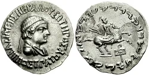
Coins provide the most substantial body of evidence for Indo-Greek political geography. The kings issued coins in Greek and Indian standards, using both round and square forms. Many carried Greek legends on one side and Prakrit legends in Kharoshthi on the other.
The abundance and geographical spread of the coinage suggest extensive mining, a substantial monetary economy, and strong commercial circulation. The adoption of Indo-Greek monetary conventions by neighbouring powers such as the Kunindas and Satavahanas indicates that these forms were influential beyond the territory of the Indo-Greek kings.
At the same time, coin finds must be interpreted carefully. A coin hoard can indicate trade, tribute, military payment, or later accumulation. It does not automatically mark a political boundary.
Mining and metal technology
The mountainous regions of the Hindu Kush and adjacent areas supported mining operations that may have supplied the Indo-Greek monetary economy. Several rulers, including Euthydemus II, Pantaleon, and Agathocles, issued cupro-nickel coins around 170 BCE. The alloy composition resembles Chinese “white copper,” leading to the proposal that metallurgical knowledge or metal itself travelled between China and Bactria.
This interpretation remains a scholarly proposal rather than a settled fact. The coins nevertheless demonstrate technical experimentation and the circulation of monetary practices across Central and South Asia.
Agriculture and urban production
Bactria was described as fertile and highly urbanised. The river-fed plains of the Punjab also supported settled agriculture and dense urban networks. Gandhara and the Kabul Valley formed intermediate zones where mountain resources, agricultural production, and long-distance trade met.
The available evidence does not provide reliable population estimates for Indo-Greek cities or the kingdom as a whole. Nor does it establish a complete catalogue of agricultural products. Ancient accounts do, however, describe Bactria as prosperous, while the distribution of coins indicates regular exchange among urban and rural communities.
Ports and commercial centres
Barygaza, modern Bharuch, is the most prominent western port connected with Indo-Greek coin circulation. The port’s location on the Gulf of Khambhat provided access to inland markets and maritime routes.
The Indus delta and the western coast of India were linked to overland routes through Sindh and the Punjab. Whether these ports belonged to the Indo-Greek state or simply received its currency remains disputed.
Cultural and Religious Geography
Greek and Indian languages
The Indo-Greek kingdoms brought Greek political and artistic traditions into sustained contact with Indian languages and institutions. Their coins are the clearest evidence of this interaction. Greek was used alongside Prakrit, usually written in Kharoshthi. Brahmi appeared on some early bilingual issues associated with Agathocles and Pantaleon.
The term Yavana, derived from “Ionian,” was used in Indian sources for Greeks and later came to designate other foreigners as well. In Pali, the related form Yona appears in Buddhist literature. These terms should not always be read as precise descriptions of ethnicity or political citizenship.
Buddhism
Buddhist connections were especially strong in Gandhara and the northwestern Indian regions. Menander is remembered in the Milinda Panha as a ruler who engaged deeply with Buddhist philosophy and converted to Buddhism. Some coins associated with Menander and later rulers use the Dharma wheel, while others use the title Dharmikasa, “Follower of the Dharma.”
Ashoka’s earlier missions may have helped establish links between Greek communities and Buddhist institutions. Greek Buddhist monks are mentioned in Pali accounts, and later Buddhist sites preserve evidence of donors identified as Yavanas.
Hindu and other religious traditions
Indo-Greek religious life was not exclusively Greek or Buddhist. Greek deities such as Zeus, Herakles, Athena, and Apollo appeared on coins. Indian animals and symbols—including the elephant, bull, lion, and Dharma wheel—also became part of the monetary imagery.
The Heliodorus Pillar at Vidisha, erected around 113 BCE, records a Greek ambassador from the court of Antialcidas who declared himself a devotee of Vasudeva. This is an important example of a Greek associated with an Indian religious tradition and of diplomatic contact between an Indo-Greek court and the Shunga realm.
The evidence points to overlapping religious identities rather than a simple replacement of Greek religion by Buddhism or Hinduism.
Sanchi and Bharhut
At Sanchi, northwestern craftsmen contributed to early stupa decoration around 115 BCE. Mason’s marks in Kharoshthi indicate links with Gandhara or nearby regions. Later reliefs show figures in Greek-style clothing, with tunics, cloaks, sandals, and musical instruments associated with the Hellenistic world.
Inscriptions at Sanchi record self-identified Yavana donors. At Bharhut, a warrior in Hellenistic dress appears on a relief dated broadly to around 100 BCE. The figure has sometimes been interpreted as a Greek or Indo-Greek soldier, although individual identification is uncertain.
These monuments reveal movement of artisans, donors, religious ideas, and visual forms across political boundaries.
Military Geography
Army organisation
The Milinda Panha describes Menander’s army as a fourfold force of elephants, cavalry, bowmen, and infantry. The text provides a rare glimpse of military organisation in the period, although it does not establish the size or distribution of the entire Indo-Greek army.
Indo-Greek coins depict soldiers wearing Hellenistic helmets and carrying spears, swords, bows, and arrows. Equestrian imagery is common. Around 130 BCE, coins of Zoilos I began to show the Central Asian recurve bow and bowcase, suggesting interaction with steppe peoples such as the Scythians or Yuezhi.
Strategic geography
The Hindu Kush passes were essential to the defence of the Kabul Valley and Gandhara. Taxila, Pushkalavati, and the cities of the Punjab controlled access between mountain routes and the plains. Bactra and the Central Asian settlements formed the northern strategic environment, while Mathura and the upper Gangetic routes represented the contested eastern direction.
The Indus and its tributaries provided both movement corridors and obstacles. Armies advancing east or west had to cross rivers, secure urban centres, and maintain access to supply routes.
Conflicts with Greco-Bactria
The Indo-Greek and Greco-Bactrian kingdoms were related but competed for control of the northwest. Eucratides I attacked Indo-Greek territory during the middle of the second century BCE. A ruler named Demetrius, identified by some scholars with Demetrius I and by others with another king, is said to have besieged Eucratides for four months.
Eucratides appears to have occupied territory as far as the Indus between approximately 170 and 150 BCE. Menander later recovered these advances. The chronology and identities of the rulers remain debated, so the map represents this frontier as politically unstable rather than fixed.
Conflicts with Indian powers
Indo-Greek armies also confronted Indian kingdoms and republics. The Hathigumpha inscription of Kharavela of Kalinga describes a Yavana king whose demoralised army retreated toward Mathura. The king’s name is damaged and has been read in different ways, including as Demetrius, but this identification creates chronological difficulties.
The Yuga Purana describes Yavana movements through Saketa, Panchala, Mathura, and toward Pataliputra. Because the text is written in prophetic form and its historical chronology is difficult, it cannot by itself establish a permanent Indo-Greek conquest of the Gangetic plain.
Pressure from the Scythians and Yuezhi
From the middle of the second century BCE, Scythian and Yuezhi movements from Central Asia transformed the political geography of Bactria and the Hindu Kush. The fall of the Greco-Bactrian Kingdom around 130 BCE removed a major northern power and increased pressure on the Indo-Greek states.
Later Indo-Greek coinage shows interaction with steppe peoples. Some rulers may have formed alliances with Indo-Scythian leaders, and Greek communities probably survived under Indo-Scythian rule. The transition was therefore not necessarily a single military conquest or an immediate disappearance of Greek populations.
Political Geography
Relations with Bactria
The Indo-Greek kingdoms emerged from the wider Greco-Bactrian political world. Dynastic links remained important, but the two regions were repeatedly divided by warfare. Bactrian expansion toward the Indus and the subsequent recovery of territory by Menander indicate that the Hindu Kush was a frontier of competition rather than an absolute cultural boundary.
Relations with the Shungas
The Shunga Empire arose after Pushyamitra Shunga overthrew the last Mauryan ruler around 185 BCE. Shunga authority extended westward into parts of the Punjab, but its precise frontier with the Indo-Greeks is uncertain.
Greek military activity in the direction of Saketa, Mathura, and Pataliputra is recorded in Indian literary traditions, while the Heliodorus Pillar shows that diplomatic relations could later become cooperative. By around 113 BCE, an Indo-Greek ambassador was able to travel to the Shunga court at Vidisha and dedicate a pillar to Vasudeva.
Local republics and successor states
After Menander’s death, much of his empire fragmented. The Yaudheya and Arjunayana republics became prominent east of the Ravi and issued coins celebrating military victory. The Audumbaras, Kunindas, Mitras, and Dattas also minted coinage in regions formerly connected with Indo-Greek influence.
These polities should not all be treated as provinces that simply became independent. Some may have been local republics, some dynasties, and some subordinate authorities. The evidence does not establish a single pattern of succession.
Contacts with the wider Hellenistic world
Ashoka’s edicts name Hellenistic rulers including Antiochus, Ptolemy, Antigonos, Magas, and Alexander. These contacts predated the Indo-Greek Kingdom but helped create a political and cultural environment in which Greek and Indian institutions could interact.
After Parthian expansion and the fall of Bactria, the Indo-Greeks became more isolated from the Mediterranean world. Nevertheless, trade through Central Asia and the Indian Ocean continued, connecting the region to distant markets.
Legacy and Decline
Fragmentation after Menander
Menander’s death around 130 BCE was followed by the reduction and fragmentation of his kingdom. New republics and dynasties arose in the east, while Indo-Scythian, Yuezhi, and Parthian pressure increased in the west and north.
Several later Indo-Greek rulers controlled smaller territories. Zoilos I, Lysias, Antialcidas, Philoxenus, Hermaeus, Strato II, and Strato III are among the kings known mainly through coins. Their reigns were often short, and the sequence of rulers remains a matter of continuing numismatic study.
Loss of the Hindu Kush and Punjab
Hermaeus, one of the last significant rulers of the Paropamisadae, probably ruled until around 80 BCE. The Yuezhi or Sakas then took control of his territories, while posthumous issues of Hermaeus continued to circulate for decades.
In the central regions, the Indo-Scythian ruler Azes I defeated Hippostratus around 48 or 47 BCE. Alliances between Indo-Greek and Indo-Scythian rulers may have existed, and Greek communities continued under new political masters.
The last Indo-Greek rulers, Strato II and Strato III, held parts of the Punjab until around 10 CE. Their territory was then conquered by the Northern Satrap ruler Rajuvula.
Continuing Greek communities
The disappearance of the Indo-Greek kingdoms did not mean the immediate disappearance of Greek people or Greek cultural practices. Greek communities probably survived under Indo-Scythian, Indo-Parthian, and Kushan rule. Isidore of Charax described Alexandria of Arachosia as Greek in the first century CE, although the meaning of “Greek” in this context may refer to urban tradition, population, or political identity.
Yavana donors appear in Buddhist cave inscriptions in western India between the first century BCE and the second century CE. At Karla, Nashik, Shivneri, Pandavleni, and Manmodi, people identified as Yavanas supported Buddhist monuments. These records demonstrate continued participation in Indian religious institutions long after the Indo-Greek kingdoms had ceased to be a major political force.
Art and intellectual exchange
The Indo-Greek legacy is especially visible in coinage, scripts, religious imagery, and the artistic traditions of Gandhara. Greek and Indian symbols appeared together on coins, while Hellenistic clothing, musical instruments, and visual forms entered Buddhist art.
The chronology of Greco-Buddhist sculpture remains debated. Some works traditionally assigned to the Indo-Scythian, Indo-Parthian, or Kushan periods may preserve earlier Indo-Greek influences, while other objects may have been produced later by artists working within an enduring Hellenistic tradition.
Greek astronomical and astrological knowledge also continued in India. Yavanesvara, a Greek writer at the court of Nahapana, translated a Greek astrological work into Sanskrit, producing the Yavanajataka, one of the earliest Sanskrit works on horoscopy.
How to Read This Map
This reconstruction should be read as a map of overlapping political, commercial, and cultural zones rather than as a modern state map. The darkest territory represents the areas most securely associated with Indo-Greek rule: the Kabul Valley, Gandhara, and the Punjab. Lighter zones indicate regions connected with campaigns, coin circulation, temporary occupation, or literary claims.
Mathura is important but contested. The Yavanarajya inscription and coin finds support a significant Indo-Greek presence, yet they do not settle whether the city was continuously governed from Sagala or another Indo-Greek capital. The proposed advance toward Pataliputra is even less certain. Ancient literary accounts preserve the memory of Yavana campaigns, but archaeological and numismatic evidence does not confirm a lasting Indo-Greek occupation there.
The map also separates political territory from trade. Indo-Greek coins travelled beyond the areas ruled by their issuers, while routes linking Bactria, India, China, and the Indian Ocean crossed many political boundaries. The historical Indo-Greek world was therefore defined not only by the land held by its kings but also by the movement of merchants, soldiers, ambassadors, craftsmen, coins, and religious teachers.