Somavamshi Kingdom in Odisha, c. 1020 CE
Introduction
The Somavamshi kingdom grew from a western Odisha base connected with Dakshina Kosala into a power that controlled or claimed large parts of Utkala and Kalinga. Its political geography changed considerably between the reign of Janamejaya I in the late ninth century and the final defeat of Karnadeva by the Eastern Ganga ruler Anantavarman Chodaganga by 1114 CE. This map follows that changing landscape through capitals, inscriptions, temple centres, and contested frontiers.
The dynasty is also known as the Keshari or Kesari dynasty. Its rulers claimed lunar ancestry, and their possible relationship with the earlier Panduvamshis of Dakshina Kosala is an important part of the kingdom’s historical background. The connection is suggested by titles, names, scripts, inscriptional practices, and the Somavamshi presence in western Odisha, but it cannot be established with certainty.
The map is best read as a reconstruction rather than a precisely surveyed political boundary. Royal grants identify particular villages, districts, capitals, and administrative officers, while later inscriptions make broad claims over Kosala, Utkala, and Kalinga. These records reveal the direction of expansion but do not preserve a uniform frontier for every year of Somavamshi rule.
Historical Context
The early Somavamshis appear to have ruled in western Odisha, a region that had formed the eastern part of Dakshina Kosala. Their earliest known ruler, Mahashivagupta I, also called Janamejaya, was described in the Chaudwar inscription as Kosalendra, or “lord of Kosala.” Several inscriptions record grants to people from Kosala, villages located in Kosala, and officers associated specifically with the region.
One historical reconstruction proposes that the Panduvamshis were displaced from Kosala by the Kalachuris and moved eastward. In this account, they established themselves at Vinitapura on the Mahanadi, identified with modern Binka. The rulers based around this centre are often called the “early” Somavamshis, in contrast to the later rulers whose territory extended over a larger part of Odisha. The relationship between the Panduvamshis and Somavamshis remains probable rather than proven.
Janamejaya I ruled approximately from 882 to 922 CE. During his long reign, he issued numerous copper-plate grants from temporary or “victorious” camps. Their distribution suggests a ruler consolidating authority across western Odisha while moving between political centres. Three grants issued from Kataka in his thirty-first regnal year are associated with Chaudwar near modern Cuttack. They indicate that Somavamshi influence had reached eastern Odisha by the end of his reign.
Janamejaya also became involved in the politics of the Bhauma-Kara kingdom. His daughter married the Bhauma-Kara ruler Shubhakara IV and later ascended the throne as Tribhuvana-Devi II, probably around 894 CE, with her father’s support. An inscription at the Brahmeswara Temple states that the king of the Odra country was killed by Janamejaya’s spear. One interpretation identifies this king with Shivakara III, while another understands “Odra” as a smaller district around present-day Dhenkanal and identifies the dead ruler as a rebellious Bhanja subordinate. The map therefore marks this episode as politically significant but historically disputed.
Yayati I, who ruled approximately from 922 to 955 CE, continued the expansion associated with his father. His inscriptions record grants in Dakshina Kosala and in areas formerly connected with neighbouring powers. Chandagrama, identified with Changan southeast of Cuttack, had belonged to Bhauma-Kara territory, while Gandatapati, identified with Gandharadi, had been located in Bhanja territory.
During or by the time of Yayati I, the Somavamshis appear to have gained control over much of Odisha, although the exact date and process remain uncertain. The capital at Vinitapura was probably renamed Yayatinagara after Yayati. It was later shifted to Guheshvarapataka, the former Bhauma-Kara capital identified with modern Jajpur, which became Abhinava-Yayatinagara, or “the new city of Yayati.”
Territorial Extent and Boundaries
At its broadest phase, Somavamshi authority is associated with three major regional names: Kosala, Utkala, and Kalinga. Kosala formed the western and north-western political foundation of the dynasty. Utkala covered the northern and central parts of present-day Odisha, while Kalinga referred to the wider eastern and south-eastern region. These terms did not necessarily describe fixed provinces with borders equivalent to modern administrative divisions.
The western frontier lay toward the Kosala region and the territories affected by Kalachuri power. The early Somavamshi centre at Binka stood on the Mahanadi, making the river basin a central geographical setting for the dynasty’s initial expansion. The eastern zone extended toward the coastal plain and the political centres around Chaudwar, Jajpur, Bhubaneswar, and Puri.
The northern and north-western limits were unstable. In the final phase, the dynasty lost territory to the Nagas in the north-west. The Kalachuris of Ratnapura conquered western areas and reached their height during the period of Somavamshi decline. To the south, the Eastern Gangas became increasingly powerful and eventually absorbed the remaining Somavamshi territories.
Not every region mentioned in royal inscriptions should be treated as a securely governed province. Yayati II, also called Chandihara, is described as the lord of Kalinga, Kosala, and Utkala, and Somavamshi records credit him with conquests as far away as Gurjara and Lata. These distant claims are generally regarded as poetic hyperbole because they lack supporting historical evidence. The map distinguishes between areas connected with sustained administration and broader claims of royal power.
By the reign of Karnadeva, the kingdom had contracted sharply. Its remaining territory was confined to a coastal tract between the modern Balasore and Puri districts. This reduced coastal kingdom fell to Anantavarman Chodaganga by 1114 CE.
Administrative Structure
The surviving record reveals a grant-based system of royal administration. Copper-plate charters recorded the transfer of villages, often to religious beneficiaries, and identify places from which the grants were issued. The repeated appearance of grants connected with Kosala shows that the region retained administrative importance even after the dynasty expanded eastward.
Janamejaya’s grants from different victorious camps suggest that the court did not remain permanently tied to one location during the early consolidation of the kingdom. Such movements may have allowed the ruler to supervise newly incorporated areas, although the exact organisation of these camps is not known.
The terms vishaya and region-specific offices appear in the inscriptional record. The debate over the “king of Odra” killed by Janamejaya illustrates the scale of these units: some historians understand Odra in that inscription as the whole country, while others identify it with a much smaller district. This uncertainty cautions against drawing rigid provincial boundaries.
Yayatinagara and Abhinava-Yayatinagara served as successive political capitals. The first is linked with Binka and the Mahanadi; the second with Jajpur and the former Bhauma-Kara centre of Guheshvarapataka. Chaudwar, near Cuttack, was another important royal centre because Janamejaya issued multiple grants there.
Infrastructure and Communications
The historical record does not preserve a complete road, postal, or military communications network for the Somavamshi kingdom. Copper-plate grants issued from several royal camps do, however, demonstrate movement between political centres and the ability of the court to authenticate and distribute land grants across a broad territory.
The Mahanadi was especially important to the early kingdom because Vinitapura, the predecessor of Yayatinagara, stood on its banks. The river connected western Odisha with the eastern plain and helped link the dynasty’s Kosala base to areas farther east. Beyond this geographic role, the surviving record does not establish the precise use of waterways, roads, or organized courier systems.
There is also no securely documented Somavamshi maritime system in the surviving evidence considered here. The kingdom reached coastal Odisha and included Puri, but the existence, scale, and organization of a royal navy or overseas trade network cannot be determined from the available historical record.
Economic Geography
Village grants are the clearest indication of the kingdom’s economic geography. They show the state asserting authority over agricultural settlements in Dakshina Kosala, Utkala, and areas formerly associated with the Bhauma-Karas and Bhanjas. The distribution of these grants suggests that control rested substantially on the integration of villages into a royal and religious landholding system.
The Mahanadi basin was a major geographical foundation of the early kingdom. Its agricultural settlements supported the political centre at Vinitapura or Yayatinagara, while the eastward expansion brought the dynasty into contact with the more densely settled coastal regions.
Specific commodities, market towns, customs stations, and port networks are not securely identified in the record summarized here. Puri was an important religious centre, especially after Yayati I was credited with building a new temple and reinstalling the image of Purushottama, or Jagannatha. Its importance in the map is therefore primarily religious and political rather than evidence of a documented Somavamshi commercial port.
Cultural and Religious Geography
The Somavamshi kings were Shaivite Hindus. The Pashupata and Mattamayura schools of Shaivism appear to have been influential during their rule. At the same time, the period witnessed a gradual shift from Buddhism toward Brahmanism, a development that had begun under the preceding Bhauma-Karas and accelerated under the Somavamshis.
Yayati I is credited with constructing a new temple at Puri and reinstalling the image of Jagannatha after the image had reportedly been removed during a Rashtrakuta invasion around 800 CE. The attribution belongs to the historical tradition surrounding the dynasty and should be distinguished from the more limited inscriptional evidence.
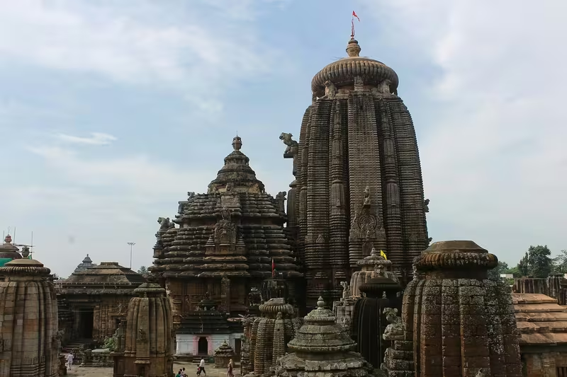
Somavamshi rule introduced a distinctive style of Odisha temple architecture, marked by new forms, ornamentation, and iconography. The Brahmeswara Temple at modern Bhubaneswar is the clearest securely attested example because an inscription explicitly attributes its construction to the Somavamshi period. During the reign of Uddyotakeshari, his mother Kolavati Devi dedicated the temple in the eighteenth year of his rule.
The construction of the Lingaraja Temple probably began during the later part of Uddyotakeshari’s reign and was completed under Janamejaya II. The Mukteshvara, Lingaraja, and Rajarani temples are all dated to the Somavamshi period, although Brahmeswara remains the monument with the clearest explicit inscriptional attribution. Uddyotakeshari also patronized the Jains of Udayagiri, showing that the religious landscape was not exclusively Shaivite.
Military Geography
The Somavamshi kingdom expanded through a mixture of dynastic alliances, military conquest, and the consolidation of village-level authority. Janamejaya’s involvement in Bhauma-Kara succession politics brought his family into the eastern political arena. His grants from mobile victorious camps suggest an active campaign and administrative environment, although individual battles are rarely described in detail.
The kingdom faced repeated external pressure in the eleventh century. A major Chola invasion reached the capital Yayatinagara in 1021 CE. There is also evidence for invasions by the Paramaras of Malwa and the Kalachuris of Tripuri. These attacks exposed the vulnerability of a kingdom whose political centres extended from western Odisha to the coastal plain.
Yayati II inherited a kingdom weakened by rival chiefs. According to the Brahmeswara Temple inscription, ministers appointed him king and he restored order. He re-established Somavamshi control over Kosala and Utkala, which had been lost during the preceding instability. The inscriptional language presents this as a restoration of royal unity, but the precise military campaigns behind it are not recorded.
During the final decline, the Kalachuris of Ratnapura seized western territory, the Nagas gained ground in the north-west, and the Gangas advanced from the south. The Somavamshi defensive system, army organization, and stronghold network are not sufficiently documented to reconstruct in detail. The map therefore emphasizes the strategic importance of the capitals, river basin, and frontier regions rather than assigning unsupported battle lines.
Political Geography
Somavamshi politics were closely connected with the Bhauma-Karas, the earlier rulers of much of coastal Odisha. Janamejaya’s daughter became a Bhauma-Kara ruler, creating a dynastic connection that may have assisted Somavamshi influence in the east. Later Somavamshi control over former Bhauma-Kara lands is clear in some grant records, but the exact mechanism by which the transition occurred is uncertain.
The Bhanjas were another important neighbouring power. Gandatapati, identified with modern Gandharadi, had previously been in Bhanja territory before appearing within the sphere of Yayati I’s grants. The interpretation of the Odra ruler killed by Janamejaya also involves a possible Bhanja subordinate.
To the west and north-west, the Somavamshis confronted Kalachuri and Naga power. The Paramaras and Cholas appear in the record as external invaders. In the south, the Eastern Gangas emerged as the decisive rival. These relationships ranged from dynastic connection and subordinate local rule to invasion and territorial conquest.
Legacy and Decline
The Somavamshi configuration lasted, in changing form, from the late ninth century until the early twelfth century. Its most expansive phase linked the western Odisha region of Kosala with Utkala, Kalinga, the Mahanadi basin, and the coastal centres of eastern Odisha. Its political geography was repeatedly rebuilt: first through Janamejaya’s consolidation, then through Yayati I’s expansion, and later through Yayati II’s restoration after foreign invasions and internal disruption.
After Uddyotakeshari, the kingdom declined gradually. Western lands were taken by the Kalachuris of Ratnapura, north-western territory was lost to the Nagas, and southern areas passed to the Gangas. Karnadeva’s authority was ultimately reduced to the coastal tract between Balasore and Puri. By 1114 CE, Anantavarman Chodaganga had conquered the remaining Somavamshi territories.
The dynasty’s enduring legacy lies especially in Odisha’s temple architecture and religious landscape. Its period saw the development of a distinctive architectural style, the strengthening of Shaivism and Brahmanical institutions, the restoration and construction of major temples, and the continued importance of Puri and Bhubaneswar. The map records not a static empire but a shifting political formation whose capitals, inscriptions, and monuments reveal the transformation of Odisha between the ninth and twelfth centuries.