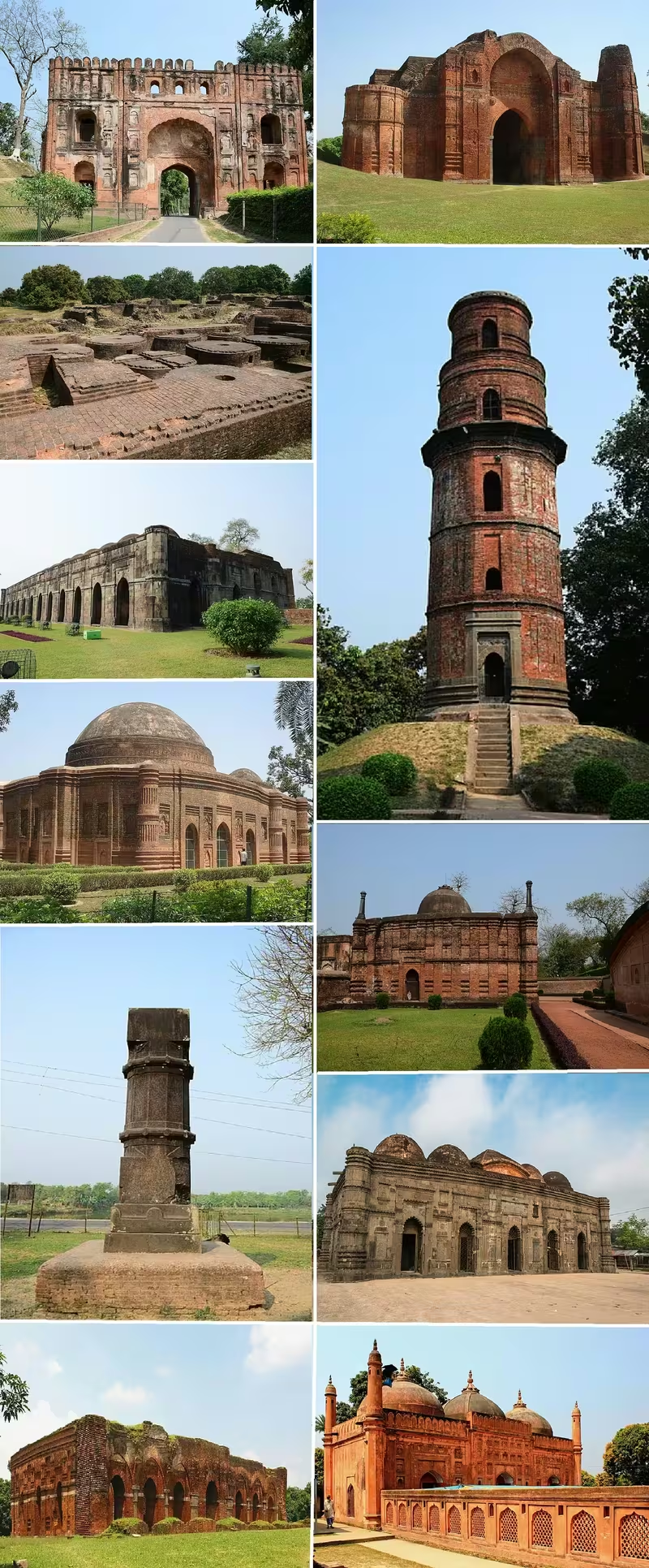
Overview
At 24°52′ north and 88°08′ east, the ruins of Gauda extend across the modern India–Bangladesh border. Most of the remains stand in West Bengal’s Malda district, while several structures lie in Chapai Nawabganj District of Bangladesh. The Kotwali Gate, once part of the city’s citadel, now marks a border checkpoint. This division is a modern political fact imposed upon the remains of a city that once formed part of a single historical landscape.
Gauda—also called Gaur, Gour, Lakhnauti, Lakshmanavati, and, during Humayun’s occupation, Jannatabad—was repeatedly chosen as a seat of power in Bengal. It was associated first with the Kingdom of Gauda, later with the Pala and Sena periods, and most visibly with the Bengal Sultanate. From 1453 to 1565, it served as the sultanate’s capital. Its citadel, palace, mosques, canals, bridges, bazaars, reservoirs, and fortified embankments made it a major political and urban centre.
The city’s scale is difficult to reconstruct because its population estimates vary widely. Richard M. Eaton gives a population of 40,000 in 1515, while other estimates place the population at 200,000 around 1500. Faria y Sousa, writing in the sixteenth century, described 1,200,000 inhabitants. These figures do not agree, but all point to a city whose size and wealth attracted notice. Its decline was connected to the end of the Bengal Sultanate, Sher Shah Suri’s invasion, plague, and the changing course of the Ganges.
Etymology and Names
The name Gauda has a long political and cultural history. In the seventh century, Shashanka ruled the Kingdom of Gauda, and his reign is associated with the beginning of the Bengali calendar. After the fall of the Gupta Empire, western Bengal was identified with the Gauda kingdom, while eastern Bengal was associated with Samatata.
Under the Pala Empire, the name acquired an even broader significance. Pala emperors used the title “Lord of Gauda,” and historian D. C. Sicar regarded Gauda as an appropriate name for the Pala Empire itself. Over time, Gaudiya—meaning “of Gauda”—became closely associated with Bengal and Bengalis. The term therefore referred not only to a city or kingdom but also to a region and cultural world.
During the Sena period, Gauda became known as Lakhnauti, a name connected with Lakshman Sena. Following the establishment of Muslim rule, the city continued to be called Lakhnauti for a time. During the Bengal Sultanate, Gaur became the commonly used form of the name. When the Mughal emperor Humayun occupied the city in the sixteenth century, he sought to rename it Jannatabad, or “heavenly city.”
These changing names reflect successive political orders rather than a single uninterrupted identity. Gauda, Lakhnauti, Gaur, and Jannatabad each belong to different stages in the city’s history.
Geography and Location
Gauda stood on the alluvial plains of Bengal, beside the Ganges. In its prosperous period, the western side of the city was washed by the river. The Ganges thus helped protect the citadel and connected the city to the wider riverine network of Bengal. Its position also contributed to the city’s strategic and commercial importance.
The city proper measured approximately 7.125 kilometres from north to south and between 1 and 2 kilometres in breadth. With its extensive suburbs, it covered an area estimated at 20 to 30 kilometres. Its outer defences consisted of massive embankments, reportedly averaging about 12 metres in height and between 61 and 200 feet in thickness at the base. The masonry facing and buildings that once covered them have disappeared, and much of the surviving earthwork is overgrown.
Inside the outer embankments stood the principal city and the citadel, with the palace in the south-western corner. Other embankments extended through the suburbs, in some directions for 30 or 40 miles according to the historical description preserved in the record. A second fortified enclosure surrounded the palace. A deep moat protected it from the outside.
The city’s relationship with the Ganges eventually became a cause of decline. From the late sixteenth century, the river’s main channel shifted towards the Padma and abandoned channels in the south-western Bengal Delta. As the water moved away from Gauda, ships could no longer approach the city as they had before. The loss of navigable access diminished its strategic and commercial value.
Ancient History
The historical record presented for Gauda begins most clearly with the seventh-century Kingdom of Gauda. Shashanka’s reign is generally placed between about 590 and 625 CE. He is described as one of the pioneering kings of Bengal, and his rule marks the emergence of Gauda as a major political centre.
The fall of the Gupta Empire created a new political division in Bengal. Western Bengal came under the Kingdom of Gauda, while eastern Bengal was ruled by the Samatata Kingdom. The rise of Gauda should therefore be understood within the political reorganisation of eastern India after Gupta power declined.
The Pala Empire later emerged in the Gauda region when Gopala became king with the approval of an assembly of chieftains. The Palas ruled for approximately four centuries and controlled large parts of northern India. Their association with Gauda was so strong that their rulers bore the title “Lord of Gauda.” This period also saw developments in the Bengali language, script, and wider Bengali culture.
The surviving remains visible today, however, are mainly from the Bengal Sultanate and Mughal periods. The earlier history of Gauda is essential to understanding its importance, but the monumental landscape is dominated by later brick and stone structures.
Historical Timeline
Gauda’s history passed through several political formations rather than belonging to a single dynasty. Its repeated selection as a capital reflects its location, fortifications, and role in the wider Bengal region.
Kingdom of Gauda
Shashanka founded the Kingdom of Gauda in the seventh century. His reign, approximately 590–625 CE, is connected with the beginning of the Bengali calendar. At this stage, Gauda was the political centre of western Bengal, while Samatata held eastern Bengal.
Pala Empire
The Pala Empire arose in the Gauda region with the accession of Gopala. The circumstances of his rise—approval by an assembly of chieftains—are part of the political memory attached to the dynasty. Pala rulers carried the title Lord of Gauda and governed an empire extending across much of northern India.
The Pala period was important not only for political expansion but also for the development of Bengali language and script. The association between Gauda and Bengal became increasingly strong, and Gaudiya came to signify the culture and people of Bengal.
Sena Kingdom
Under the Sena dynasty, Gauda was known as Lakhnauti. The name honoured Lakshman Sena. This period continued the city’s association with royal power, although the major monuments visible today belong largely to later centuries.
Delhi Sultanate and Lakhnauti
In 1203, Gauda was conquered by Bakhtiyar Khalji, a lieutenant of the Ghurid ruler Muhammad of Ghori. During the early thirteenth century, Lakhnauti was governed by a succession of officials connected to the Delhi Sultanate. Bakhtiyar left Shiran Khalji in charge when he departed on a campaign towards Tibet in 1206. Shiran was followed by Ali Mardan Khalji and Iwaz Khalji.
Iwaz Khalji declared independence from Delhi, though his rule ended in his death. In 1281, Nasiruddin Bughra Khan, the governor of Lakhnauti, again declared independence. His son, Ruknuddin Kaikaus, expanded the kingdom towards Satgaon in the south, Bihar in the west, and Devkot in the north.
Kaikaus’s successor, Shamsuddin Firuz Shah, continued this expansion. He consolidated power in Satgaon and then took control of Mymensingh and Sonargaon. In 1303, Firuz’s nephew Sikandar Khan Ghazi and commander-in-chief Syed Nasiruddin joined Shah Jalal and his forces in the conquest of Sylhet. Sylhet was subsequently incorporated into Firuz’s kingdom. His successor, Ghiyasuddin Bahadur Shah, later lost independence to the Delhi Sultanate.
Bengal Sultanate
The Bengal Sultanate gave Gauda its most prominent medieval architectural form. Shamsuddin Ilyas Shah, formerly Delhi’s governor in Satgaon, rebelled and overthrew Gaur’s governor Alauddin Ali Shah in 1342. In 1352, Ilyas Shah united Bengal into an independent state separate from Delhi.
Pandua initially served as the sultanate’s capital. In 1450, Sultan Mahmud Shah announced that the capital would move from Pandua to Gaur, and the transfer was completed by 1453. Gauda remained the capital for more than a hundred years, until 1565.
The capital contained a citadel, royal palace, durbar, mosques, aristocratic residences, merchant quarters, and bazaars. Portuguese travellers compared its affluence with Lisbon. A high wall enclosed the palace, and a moat surrounded it on three sides. The Ganges guarded the western side of the citadel.
Gauda also played a role in regional diplomacy and warfare. The deposed Arakanese king Min Saw Mon received asylum there. The Bengal sultan later sent an expedition from Gauda to support the reconquest of Arakan. The campaign was led by Paragal Khan and his son Chhuti Khan, with Prince Abdul Samad Zakir Shah.
Mughal Occupation and the End of the Sultanate
In the sixteenth century, Humayun occupied Gauda and attempted to rename it Jannatabad. The city was later looted during Sher Shah Suri’s invasion. After 1565, Sultan Sulaiman Khan Karrani shifted the capital to Tandah.
A Mughal force led by Munim Khan captured Gauda in 1575. The Bengal Sultanate formally ended with the Battle of Rajmahal in 1576. Although Mughal structures were added to the city, Gauda no longer recovered its position as the principal capital of Bengal.
Political Significance
Gauda’s importance lay above all in its repeated role as a capital. It was the centre of Shashanka’s Kingdom of Gauda, a major political reference point under the Palas, and a royal city under the Senas. Under the Bengal Sultanate, it became the seat from which an independent Bengal was administered.
The city’s citadel and palace represented the concentration of political authority. The palace complex contained a durbar and separate living quarters for the sultan and his household. Its walls, moat, controlled gates, and water arrangements formed a protected royal district within the wider fortified city.
The city’s position also enabled rulers to project power beyond its immediate surroundings. Military expeditions towards Sylhet and Arakan were associated with its rulers and commanders. Its political importance was therefore both administrative and strategic.
Religious and Cultural Importance
Gauda’s religious landscape included mosques, Sufi structures, royal buildings, tombs, and spaces connected with Hindu practice. The Kadam Rasul Mosque, built in 1530, is still used. The tomb of the saint Makhdum Shaikh Akhi Siraj stands near the Sagar Dighi. A burning ghat in the neighbourhood was traditionally regarded as the only one permitted for Hindu use by the Muslim conquerors, and it remained a revered and frequently visited place.
The city was also a centre of Bengali cultural development. The Pala period contributed to the development of Bengali language and script, while the term Gaudiya became broadly associated with Bengal and Bengalis. Medieval Bengali literary traditions also preserve references to the city. The poet Krittibas Ojha described the guarded gates along the road from the Dakhil Darwaza to the durbar.
European visitors later recorded Gauda’s buildings and prosperity. Its ruins were depicted by European painters during the eighteenth and nineteenth centuries. Colonial officials, including Francis Buchanan-Hamilton and William Francklin, conducted detailed surveys of the former capital.
Economic Role
Gauda was one of several major commercial centres in medieval Bengal, alongside Pandua, Chittagong, Sonargaon, and Satgaon. Its bazaars accommodated merchants and its urban infrastructure included canals and bridges. Castenhada de Lopez described houses with courtyards and gardens, while Portuguese accounts commented on the city’s wealth.
Bengal attracted merchants from across Eurasia, as well as immigrants from North India, the Middle East, and Central Asia. Gauda benefited from this movement of people and goods. Its connection with the Ganges was particularly important: the river served as a defensive boundary, a transport route, and a link to other parts of the delta.
The eventual movement of the Ganges away from the city undermined this economic role. When ships could no longer sail north of Saptagram because of the altered river channels, Gauda’s access to regional waterborne trade was weakened.
Monuments and Architecture
Gauda’s architecture is predominantly associated with the Bengal Sultanate. James Fergusson described its style as distinct from Delhi, Jaunpur, and other northern traditions. Heavy, short stone pillars supported pointed arches and brick vaults. Small, thin bricks were widely used, while glazed tiles added colour to walls and surfaces.
The Dakhil Darwaza formed the principal entrance to the citadel. It dates from approximately 1459–1474 and was part of a strongly fortified enclosure. Nearby stood the palace, enclosed by a brick wall said to have been about 20 metres high in places.
The Bara Sona Mosque, also known as the Great Golden Mosque or Bara Darwaza, is regarded in the historical description as the finest ruin at Gauda. Dated to 1526, it originally had thirty-three domes. The surviving arched corridor has eleven arches along each side and one at each end, possibly explaining the association with the name “twelve-doored.” Its surviving domes and long façade convey the scale of the original building.
The Tantipar Mosque, dated to 1475–1480, is noted for its brick moulding. The Lotan Mosque, from approximately the same period, is distinguished by its glazed tiles. These buildings demonstrate the importance of ornamented brickwork in the architecture of Bengal.
The Kadam Rasul Mosque dates to 1530 and remains in use. Close to it stands the Firoz Minar, a tall tower whose name may indicate a tower of victory. Around the Sagar Dighi are several Muslim structures, including the tomb of Makhdum Shaikh Akhi Siraj.
Mughal additions include the two-storeyed Tahkhana complex. The Persian word tahkhana suggests a cool interior environment, and the complex appears to have incorporated ventilation intended to moderate humid temperatures. It was also used as a Sufi khanqah. The Lukochori Darwaza, or “hide and seek gate,” stood on the road leading to the complex. These structures are associated with the reign of Viceroy Shah Shuja.
Famous Personalities
Shashanka is the earliest major ruler associated with Gauda. His reign, approximately 590–625 CE, marks the rise of the Kingdom of Gauda and is linked with the beginning of the Bengali calendar.
Gopala, the founder of the Pala Empire, rose to kingship in the Gauda region with the approval of an assembly of chieftains. The Pala emperors continued to use the title Lord of Gauda.
Lakshman Sena gave the city the name Lakhnauti during the Sena period. Bakhtiyar Khalji conquered Gauda in 1203 and established the next major phase of its political history.
Shamsuddin Ilyas Shah founded the independent Bengal Sultanate in the fourteenth century by uniting Bengal outside Delhi’s control. Sultan Mahmud Shah later ordered the transfer of the capital from Pandua to Gauda. Humayun occupied the city in the sixteenth century and called it Jannatabad, while Shah Shuja was associated with the construction of the Tahkhana complex.
Decline and Revival
Gauda’s decline resulted from several connected developments. The Bengal Sultanate lost its capital after Sulaiman Khan Karrani moved the court to Tandah in 1565. The city then experienced invasion, looting, and political transformation. Sher Shah Suri’s forces sacked it, and Mughal control followed.
Disease accelerated the decline. An outbreak of plague contributed to the abandonment of the city. At roughly the same time, the Ganges altered its course. Its main channel shifted towards the Padma, leaving the channels near Gauda. The city lost its riverine access and therefore much of its strategic importance.
A new Mughal capital later developed first at Rajmahal and then at Dhaka. Gauda became a heap of ruins in the wilderness, increasingly overgrown with jungle. Its buildings were also treated as a quarry by neighbouring towns and villages. The government took steps towards preservation in 1900.
Modern revival has taken the form of archaeological study and conservation rather than urban reconstruction. The Archaeological Survey of India and Bangladesh’s Department of Archaeology now share responsibility for structures divided by the international border. Excavations near the Chikha building, within the Baisgaji Wall, have revealed remains interpreted as part of a palace. A permanent exhibition at Metcalfe Hall in Kolkata displays photographs, information about restoration, brick moulding, and glazed tiles from Gauda.
Modern City
Gauda no longer exists as a functioning city. Its remains are dispersed through a landscape that crosses the India–Bangladesh border. The Kotwali Gate functions as a border checkpoint, while the surviving monuments are approached through different modern routes.
From India, bus and rail services connect Kolkata with Malda town. Gour Malda is the nearest railway station, and Malda Town is the recommended point of access. From Bangladesh, Gauda can be approached through the Sonamosjid checkpoint, near the Choto Sona Mosque in Chapai Nawabganj District.
The ruins are valuable not only for their individual monuments but also for the urban system they reveal: fortified embankments, palace enclosures, a moat, reservoirs, roads, gates, mosques, and residential areas. Their preservation remains challenging because vegetation, weather, previous reuse of building materials, and the division between two national jurisdictions have all shaped what survives.