Overview
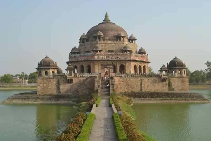
At Sasaram, a 122-foot red sandstone tomb rises from the middle of an artificial lake. The monument belongs to Sher Shah Suri, the Afghan ruler who defeated the Mughal emperor Humayun and governed much of northern India, present-day Pakistan, and eastern Afghanistan as head of the Sur Empire. The tomb is the clearest expression of Sasaram's place in sixteenth-century political history, but it is only one layer of a much older landscape.
Sasaram is the administrative headquarters of Rohtas district in Bihar. It lies near the Kaimur Range, a region of hills, forests, lakes, rivers, and seasonal waterfalls. The city and its surroundings preserve an Ashokan Minor Rock Edict, the imposing Rohtasgarh Fort, Sur-era tombs, temples, and later urban institutions. Its historical identity therefore connects imperial administration, fortified hill country, religious sites, agriculture, and modern transport.
The city served as the capital of the Sur dynasty during Sher Shah Suri's rule. It was also associated with his family: the tomb of his father, Hasan Khan Suri, stands at Sherganj, while the unfinished tomb of his son and successor, Islam Shah Suri, lies roughly a kilometre north-west of Sher Shah's monument. Sasaram's heritage is consequently not represented by a single building but by a connected group of sites.
Etymology and Names
The name Sasaram is associated with Sahasrarama, interpreted as “one thousand groves.” Another historical form, Shah Sarai, means “Place of the King” and is connected with the city's association with Sher Shah Suri. The city is also written as Shahasaram and Sasseram.
The region has several older and legendary associations. The historical account identifies Sasaram with the ancient Kashi kingdom during the Vedic age. It also connects the surrounding Rohtas area with Raja Harishchandra and his son Rohitashwa. These traditions form part of the cultural memory of the region, although the surviving historical record does not establish every detail of the early stories.
Geography and Location
Sasaram is located at approximately 24.95° north and 84.03° east in Rohtas district, Bihar. The city occupies about 15 square kilometres and has an average elevation of 110 metres. The plateau region of the Kaimur Range near Sasaram rises to an average elevation of about 210 metres.
The hills shape both the scenery and the historical character of the area. Sasaram is surrounded by hills on two sides, while the wider Kaimur landscape contains waterfalls, lakes, rivers, and forested areas. The Ain-i-Akbari is cited in connection with the picturesque landscape, and more than 200 waterfalls are said to emerge during the rainy season. Dhua Kund, approximately 15 kilometres from the city, is among the best-known waterfalls.
The climate is described as humid subtropical, with relatively high temperatures and precipitation distributed through the year. Seasonal rain transforms the surrounding hills and ravines, producing the waterfalls for which the region is known. The landscape also supports fertile agricultural land and a prominent canal irrigation system.
Ancient History
Sasaram's early history is represented by traditions, imperial inscriptions, and the long historical importance of the Kaimur hills. During the Vedic age, the region is described as part of the ancient Kashi kingdom. Its name, Sahasrarama, preserves an older association with groves and settlement.
The most direct early imperial evidence is an inscription of Ashoka. The Ashokan inscription near Sasaram is one of the Minor Rock Edicts and is located in a small cave near Chandan Shaheed, close to the upper part of a terminal spur of the Kaimur Range. The surviving record is identified as Minor Rock Edict I.
In the edict, Ashoka speaks as a lay worshipper and urges both people of high status and those of humble position to be zealous. He also records that the proclamation was issued during a tour, after 256 nights had been spent travelling. The text instructs that the message be engraved on rocks and, where stone pillars existed in his dominion, on those pillars as well. This inscription places Sasaram within the communications and moral-political landscape of the Mauryan Empire.
The source does not establish a continuous urban history from the Mauryan period to the medieval era. What it does show is that the wider region was connected to imperial authority and public inscription by Ashoka's time.
Historical Timeline
Mauryan Period
The Ashokan rock edict is the principal surviving Mauryan-era marker near Sasaram. It is not a royal palace or urban monument, but a proclamation cut into the landscape of the Kaimur hills. Its location on a hill spur demonstrates how imperial messages could be placed in prominent or travelled environments beyond a capital city.
Rohtasgarh and Early Medieval Traditions
Rohtasgarh Fort, situated south of Sasaram, is described as having a history dating to the seventh century CE. Tradition attributes its construction to Raja Harishchandra, who is said to have named it after his son Rohitashwa. The fort's present complex includes structures from different centuries, making it difficult to reduce its history to a single moment of construction.
The fort later became connected to the political geography of Bihar and Bengal. During Akbar's reign, it served as the headquarters of Raja Man Singh, who governed Bihar and Bengal as the Mughal governor. The fort should not be confused with the other Rohtas Fort near Jhelum in present-day Pakistan.
Sur Dynasty
Sasaram's most prominent historical association belongs to Sher Shah Suri. Born in the city, Sher Shah defeated Humayun and established the Sur Empire. He ruled for five years over Delhi and large parts of northern India, present-day Pakistan, and eastern Afghanistan.
During his rule, Sasaram served as the capital of the Sur dynasty. The city also became the setting for a remarkable group of funerary monuments. Sher Shah's tomb, Hasan Khan Suri's tomb, and Islam Shah's incomplete tomb together reflect the importance of Sasaram to the ruling family.
Sher Shah's administrative practices influenced later Mughal and British systems. These included approaches to taxation and administration, as well as the construction of a paved road linking Kabul and Bengal, known as the Grand Trunk Road. Sasaram's importance during this period was therefore not only dynastic. It formed part of a wider programme of governance, movement, and imperial infrastructure.
Mughal and Later Historical Connections
The history of Rohtasgarh remained important after Sher Shah. The fort was associated with the Mughal administration under Akbar through Raja Man Singh. The region's forts, roads, and hill approaches gave it strategic value, while the monuments of Sasaram preserved the memory of the Sur rulers.
The available historical account does not provide a complete political narrative for every period between the Sur dynasty, the Mughals, and the modern era. It does, however, show that Sasaram remained tied to the changing systems of regional and imperial power.
Colonial and Modern Era
Modern Sasaram developed as an administrative, agricultural, educational, and transport center. Rohtas district was carved out of Shahabad district in 1972, and Sasaram became its headquarters. The city is also the headquarters of a community development block containing 171 villages, of which 144 are inhabited and 27 are uninhabited.
The city is now connected to industrial and commercial centers including Dehri-on-Sone, Dalmianagar, Sonnagar, Amjhor, Nokha, and Banjari. The closure of Dalmia Group industries at Dalmianagar caused widespread unemployment, while Sasaram's economy continued to rely largely on agriculture and related industries.
Political Significance
Sasaram's political importance rests above all on its role as Sher Shah Suri's capital and birthplace. The city was the home base of a ruler whose short reign left a substantial mark on the administration and infrastructure of northern India. His methods were later adopted or adapted by the Mughals and the British Raj.
The nearby Rohtasgarh Fort adds a military dimension to this history. Built and expanded across different periods, the fort includes spaces identified as the Churasan Temple, Ganesh Temple, Diwan-i-Khas, and Diwan-e-Aam. It was also associated with Sher Shah's efforts during the period when Humayun was exiled from Hindustan. Its location in the hills made it a major defensive and administrative site.
Since 1972, Sasaram's political role has been primarily administrative. It is the headquarters of Rohtas district and a constituency for both the Bihar Legislative Assembly and the Lok Sabha.
Religious and Cultural Importance
Sasaram's religious landscape includes temples, shrines, inscriptions, and places associated with local devotion. The temple of Goddess Tarachandi lies about two miles south of the city. An inscription of Pratap Dhawal is reported on a rock near the temple of Chandi Devi. Large numbers of Hindus gather at Tarachandi to worship the goddess.
Other religious attractions in the wider Sasaram area include Tutla Bhawani Mandir and Narayni Devi Mandir. The city and its surrounding region are also home to communities following Hinduism, Islam, Buddhism, Christianity, Sikhism, and Jainism.
The Ashokan inscription contributes a different kind of cultural significance. It is a physical record of Mauryan imperial communication and Buddhist-era political ethics, even though the edict itself is concerned with zeal and moral conduct rather than a local foundation story.
Sasaram's living culture is multilingual. Bhojpuri, Hindi, English, and Urdu are widely spoken in the region. Its schools and colleges, railway station, markets, religious sites, and historic monuments bring together the city's older regional identity and its modern public life.
Economic Role
The fertile land around Sasaram supports extensive agriculture. The region is known as Dhan Ka Katora, or “a bowl of food grains,” reflecting the importance of rice and other agricultural products. Rice grown near Sasaram is sold in markets including Kolkata and New Delhi.
Agriculture is supported by canal irrigation, while rice polishing forms an important related industry. The city functions as a trading center for food grains, agricultural products, and agricultural equipment. Rock quarrying is identified as the only significant extractive industry.
Sasaram sits among towns with agriculture-based industries, including Nokha and Kudra. Its position between industrial centers such as Dehri-on-Sone and Dalmianagar has also shaped its modern economic connections, even as industrial closures have created employment challenges.
Monuments and Architecture
Sher Shah Suri's tomb is Sasaram's defining monument. Built in red sandstone in the Indo-Afghan style, it stands 122 feet high in the centre of an artificial lake. Its design draws heavily on the Lodhi style. Traces of blue and yellow glazed tiles indicate Iranian influence, while the massive free-standing dome has been noted for an aesthetic resemblance to the Buddhist stupa tradition of the Mauryan period.
The tomb of Hasan Khan Suri, Sher Shah's father, stands in a green field at Sherganj. It is known as Sukha Rauza. About a kilometre north-west of Sher Shah's tomb is the incomplete and dilapidated tomb of Islam Shah Suri, Sher Shah's son and successor. Sasaram also contains a Baulia, a pool reportedly used by the emperor's consorts for bathing.
Rohtasgarh Fort is the area's major military monument. Its buildings belong to different centuries and include religious, ceremonial, and administrative structures. The presence of a Diwan-i-Khas and Diwan-e-Aam reflects the fort's role as more than a defensive enclosure: it also functioned as a centre of governance.
Other attractions listed in the Sasaram region include Shergarh Fort, Salim Khan's tomb, Manjhar Kund, Kashish waterfall, Karmchat Dam, Dhua Kund, and the temples of Tutla Bhawani and Narayni Devi.
Famous Personalities
Sher Shah Suri is the most closely associated historical figure. Born in Sasaram, he became the founder of the Sur Empire after defeating Humayun and ruled for five years. His administrative and road-building policies influenced later governments.
Hasan Khan Suri, Sher Shah's father, is commemorated by the tomb at Sherganj. Islam Shah Suri, Sher Shah's son and successor, is associated with the unfinished tomb near his father's monument.
Other figures connected with the region include Raja Man Singh, who used Rohtasgarh as a headquarters while serving as governor of Bihar and Bengal under Akbar, and Raja Harishchandra, who belongs to the fort's traditional origin story.
Decline and Revival
Sasaram did not disappear after the end of Sur rule. Its significance shifted from an imperial capital to a regional administrative and commercial center. The historic monuments remained, while the surrounding agricultural landscape continued to support settlement and trade.
In modern times, the city has faced economic difficulties, particularly after the closure of industries in Dalmianagar. At the same time, Sasaram has expanded as an educational hub. It contains government colleges, medical institutions, an engineering college, schools, and training institutes. Many students also travel to larger cities for higher education.
Its heritage and natural landscape offer another avenue of renewal. The tombs, forts, Ashokan inscription, temples, hills, and waterfalls give the city a distinctive cultural and tourism profile. Sher Shah Suri's tomb is included on UNESCO's World Heritage Centre Tentative List, though this status is not the same as inscription on the World Heritage List.
Modern City
According to the 2011 census, Sasaram's urban agglomeration had a population of 351,408. Males constituted 52 percent and females 48 percent. The literacy rate was 80.26 percent, above the national average cited for the period; male literacy was 85 percent and female literacy 75 percent. The city was described as the eighth most populous in Bihar.
The wider Sasaram block had a population of 358,283 in 2011, including a rural population of 210,875 across 34,336 households. These figures refer to different administrative units and should not be treated as the same population measure.
Sasaram Junction is a major railway station. Other stations in the area include Shivsagar, Kumahu, Nokha, Karwandiya, Pahleja, and Dehri on Sone. Trains connect the city with Kolkata, Arrah, Ranchi, Patna, New Delhi, and Bikramganj, among other destinations. Suara Airfield is currently non-operational; the nearest major airports are at Gaya, Patna, and Varanasi.
The city combines a historic core of tombs, forts, inscriptions, and religious sites with modern education, agriculture, transport, and administration. Its significance lies in the way these layers remain visible together: Mauryan inscription, medieval fortification, Sur imperial memory, and contemporary regional life.