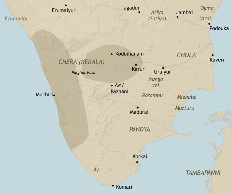
Early Chera Territory and Trade Routes, c. 200 BCE–300 CE
Introduction
The early Chera realm occupied a strategically important zone at the southern tip of the Indian peninsula. During the early historic or Sangam period, approximately from the second century BCE to the third century CE, Chera influence extended across central Kerala and western Tamil Nadu. Its geography brought together the Arabian Sea, the mountain passes of the Western Ghats, the river valleys of the Kongu country, and the inland capital of Vanchi-Karuvur, identified with modern Karur.
This map presents the Chera country not simply as a shaded political area, but as a connected landscape of capitals, ports, river routes, mountain passages, craft centres, and commercial networks. The principal maritime centres were Muchiri-Vanchi, usually identified with Muziris, and Thondi, known in Graeco-Roman accounts as Tyndis. Inland, Karur served as a political and economic centre. The route between these zones passed through the Palakkad Gap, followed the Noyyal River valley, and continued toward Kodumanal and Karur.
The Cheras were one of the three crowned dynasties of Tamilakam, alongside the Cholas and Pandyas. Their traditional emblem was the bow and arrow. Inscriptions, coins, Tamil-Brahmi records, Sangam poetry, and Graeco-Roman accounts together show a polity deeply involved in regional agriculture, craft production, inland exchange, and maritime commerce. At the same time, the precise shape of Chera authority remains difficult to reconstruct. The surviving evidence does not establish a single, sharply defined frontier comparable to the borders of a modern state.
Historical Context
The Cheras among the Three Crowned Kings
Early Tamil traditions describe the Cheras, Cholas, and Pandyas as the mu-ventar, or Three Crowned Kings, of Tamilakam. Their political centres were associated broadly with Karur or Vanchi for the Cheras, Uraiyur for the Cholas, and Madurai for the Pandyas. These kingdoms emerged in a landscape that included agricultural plains, forested uplands, river valleys, coastal settlements, and semi-autonomous chieftaincies.
The Chera country was especially well placed for contact with the Arabian Sea. The Western Ghats separated the Malabar Coast from the interior Tamil plains, but the Palakkad Gap created a significant natural passage through this mountain barrier. Through this corridor, goods and people could move between the coast and the Kongu country. The Noyyal River valley formed part of the route leading eastward toward Kodumanal and Karur.
Chera political influence is documented by the third century BCE under the name “Kedalaputo” in the edicts of the Maurya emperor Asoka. The form is generally connected with Kerala Putra or Keralaputra. Later Graeco-Roman writers used forms such as “Kaelobotros,” “Kerobottros,” and “Keprobotras.” These names are understood as adaptations or corruptions of an Indo-Aryan form related to Keralaputra.
Evidence from Tamil Literature
The major literary evidence for early Chera history comes from Sangam literature. The Pathitrupathu, Agananuru, and Purananuru refer to Chera rulers, battles, gifts, ports, landscapes, and political relationships. These poems are valuable but cannot be read as a continuous royal chronicle. Many are praise poems, and their representations of victory, generosity, and royal power may also have served to legitimise political authority.
The Pathitrupathu is particularly important for the Cheras. It was organised into ten decads, each devoted to a ruler or member of the ruling family, although two of the decads are no longer available. The collection preserves names and achievements but has not yielded a fully settled chronology.
The celebrated ruler Chenkuttuvan, known in early Tamil tradition as “Kadal Pirakottiya” Chenkuttuvan, is associated with the traditions of Kannaki, the central figure of the Tamil epic Chilappathikaram. The epic describes the consecration of a Pattini temple at Vanchi and places the Sri Lankan king Gajabahu among those present. This Gajabahu–Chenguttuvan synchronism has been used to place Chenkuttuvan and other Chera rulers in the first or second century CE, although the dating depends on several historical and literary assumptions.
Other rulers named in the literary tradition include Mantharam Cheral Irumporai, Kanaikkal Irumporai, Perum Cheral Irumporai, Kuttuvan Kodai, Makkodai, and Vel Kelu Kuttuvan. The poems portray a political world of warfare, alliances, captivity, tribute, heroic reputation, and competition among kings and chiefs.
Epigraphic Evidence
Two nearly identical Tamil-Brahmi inscriptions from Pugalur, near Karur, are among the most significant records for the early Cheras. Dated approximately to the second century CE, they refer to three generations of Chera rulers. The inscriptions record the construction of a rock shelter for Chenkayapan, a Jain monk, during the investiture of Kadungon Ilam Kadungo, son of Perum Kadungon and grandson of Athan Cheral Irumporai.
A short Tamil-Brahmi engraving from the Edakkal Caves in the Western Ghats contains the word “Chera,” while another engraving from the same location reads “Ko Athan,” possibly referring to a Chera ruler. Tamil-Brahmi inscriptions have also been found at Kodumanal, Aiyamalai, and Arachalur.
These records do not provide a complete boundary map. They do, however, connect the Chera ruling family with both the Karur region and the western mountain zone. Together with coins and archaeological discoveries, they demonstrate that Chera political and commercial activity extended across more than one ecological region.
Territorial Extent and Boundaries
The Chera Core
The early historic Chera country broadly consisted of present-day central Kerala and western Tamil Nadu, especially the Kongu country. The map therefore depicts a connected west–east sphere rather than a uniformly administered block. The western zone included the Malabar Coast and its ports, while the eastern zone centred on Vanchi-Karuvur or Karur in the interior.
The Chera heartland was shaped by three geographic features:
- the Arabian Sea and the Malabar Coast;
- the Western Ghats and their passes;
- the river valleys and plains leading into western Tamil Nadu.
This arrangement gave the Cheras access to maritime commerce while also connecting them to inland craft and agricultural centres.
Western Frontier
The western frontier faced the Arabian Sea. The Malabar Coast provided access to maritime routes crossing the Indian Ocean. Muchiri or Muziris was described as a major port where large ships associated with Romans, Arabs, and Greeks arrived. Thondi was another important port and regional headquarters.
The ancient coastline cannot be reconstructed with absolute precision from the surviving evidence. Muziris is especially uncertain. Archaeological excavations at Pattanam near Kochi have revealed a brick-lined wharf constructed with laterite granules, lime, and clay, along with amphora sherds, terra sigillata, carnelian intaglios, and Roman glass. These discoveries have strengthened the case for connecting Pattanam with the ancient port, but the identification remains a subject of historical discussion.
Eastern Frontier
The eastern part of the Chera sphere reached into western Tamil Nadu and the Kongu country. Karur, on the Amaravati River, was the most important inland centre shown on the map. It functioned as a political capital, craft-production centre, and node in long-distance trade.
The route from the coast passed through the Palakkad Gap and the Noyyal River valley before reaching Kodumanal and Karur. The corridor is supported by archaeological evidence, including craft remains, coins, and imported materials. The eastern frontier should not be understood as a fixed line. Chera authority in the Kongu country was associated with the Irumporai or Porai branch of the family, and different branches may have competed for leadership.
Northern and Southern Zones
The surviving evidence supports Chera influence in central Kerala and western Tamil Nadu, but does not fix precise northern and southern borders. The northern Kerala region was associated with Ezhimala rulers, while the southern tip of Kerala was controlled by the minor Ay dynasty. These neighbouring powers indicate that the Chera country was part of a politically plural landscape.
The map consequently distinguishes between the broad Chera sphere and areas that cannot be assigned securely to direct Chera administration. Political influence, alliance, tribute, and commercial access may have extended beyond the central territories represented as the core.
Direct Rule, Branches, and Chieftains
Early historic southern Indian political organisation remains debated. One interpretation identifies a rudimentary state structure supported by inscriptions, dynastic coinage, urban centres, specialised crafts, long-distance trade, royal insignia, and references to tolls or customs duties. Another interpretation emphasises chiefdoms, kinship-based authority, tribute, redistribution, and limited central control.
Both perspectives warn against treating the Chera kingdom as a centralised territorial state in the modern sense. The Chera family appears to have included collateral branches ruling in different regions. Multiple branches may have governed simultaneously in central Kerala and the Kongu country. Local Velir chieftains and other subordinate rulers likely retained significant authority, although the exact nature of their obligations is not always clear.
Administrative Structure
A Political Network Rather Than a Modern Province System
No complete administrative division of the early Chera country survives. The evidence does not identify a regular province system, census structure, or uniform bureaucracy. The map therefore represents political geography through capitals, ports, routes, inscriptions, and spheres of influence.
At the top of the hierarchy stood the Chera ruler or ruling lineage, identified by royal titles and the bow emblem. Princes carried titles or name elements such as “Ko” and “Kon.” The Pugalur inscriptions refer to the Chera king as “Ko” and mention an investiture ceremony for an heir apparent, suggesting a recognised system of succession.
Below the ruling family were local chiefs and regional authorities. Sangam poems frequently describe relationships involving tribute, gift-giving, warfare, alliance, and personal loyalty. Such relationships could produce political influence without requiring continuous direct administration.
Karur as Inland Capital
Karur, or Vanchi-Karuvur, was the central inland capital represented on the map. Its location on the Amaravati River helped connect it with the Kaveri basin and the routes leading west to the Palakkad Gap. Excavations have identified it as an important political and economic centre.
The city was associated with jewel making and other forms of craft production. Copper coins bearing Chera symbols have been recovered there, as have pieces of Roman amphorae. Roman coins were also found near Vellavur and in the Amaravati riverbed. These discoveries indicate that Karur was connected to both local circulation and wider commercial systems.
Coastal Headquarters
Muchiri-Vanchi and Thondi served as coastal capitals or regional headquarters as well as ports. Their importance derived from their position in the Indian Ocean trade system. The coastal centres were not merely points where goods were loaded onto ships. They were also places where merchants, rulers, local communities, and foreign navigators interacted.
The commercial role of these ports may have contributed to the authority of Chera rulers. Literary and historical interpretations suggest that rulers were involved in controlling ports and imposing rudimentary tolls or customs duties. The scale and organisation of such fiscal systems remain uncertain.
Local Communities
Early Tamil society was organised through communities, clans, occupational groups, agricultural settlements, fishing communities, pastoral groups, and craft specialists. The term “kudi” is associated with clan-based descent groups linked to production, lineage, and hereditary occupations.
The political geography of the Chera country was therefore also a social geography. Agricultural plains, mountain communities, ports, craft settlements, and inland market centres had different economic functions. Authority was exercised through relationships with these communities rather than necessarily through a uniform administrative apparatus.
Infrastructure and Communications
The West–East Trade Corridor
The most important overland corridor shown on the map ran from the Kerala coast through the Palakkad Gap and along the Noyyal River valley to Kodumanal and Karur. It linked maritime ports with the interior of Tamil Nadu.
This route took advantage of natural geography. The Palakkad Gap provides a relatively accessible passage through the Western Ghats. The Noyyal valley then helped connect the mountain passage with the inland plains. From Kodumanal, the route continued toward Karur, where goods could enter broader riverine and overland networks.
The route was not necessarily a single engineered road. It should be understood as a corridor composed of paths, river crossings, settlements, production centres, and market connections. Archaeological evidence allows its broad course to be traced even though the exact road surface and transport organisation are not known.
Rivers and Inland Movement
The Amaravati River was central to Karur’s location. The city’s relationship with the river supported settlement, agriculture, movement, and commercial exchange. The Kaveri River lay near the wider Karur region, while the Noyyal River connected the interior route with the western mountain passage.
Riverbeds near Karur have yielded coins and other material. These finds may reflect circulation, loss, deposition, or later disturbance, and should not automatically be interpreted as evidence for a mint or market at every findspot. In Karur itself, however, the discovery of bronze dies indicates the presence of a minting operation.
Maritime Communications
The Chera ports participated in Indian Ocean navigation shaped by monsoon winds. Winds from the Arabian Sea could carry ships toward the southwest coast of India, while knowledge of seasonal patterns enabled longer-distance voyages.
The Periplus Maris Erythraei, a first-century CE Greek sailing manual, describes the trade of the Chera territory under the name “Keprobotras.” It presents Muziris as a major centre with large ships associated with Romans, Arabs, and Greeks. Pliny the Elder and Claudius Ptolemy also referred to the region in the first and second centuries CE.
These accounts demonstrate maritime connectivity but do not establish that foreign merchants controlled the Chera ports. The political and economic terms of trade between local rulers, Indian merchants, and Mediterranean or Middle Eastern navigators remain debated.
Communication and Political Integration
No postal system or formal imperial communication network is documented for the early Cheras. Communication likely depended on established routes, merchants, court representatives, religious communities, poets, and local chiefs. The circulation of Tamil-Brahmi inscriptions and coins shows that writing and political symbols travelled beyond a single royal residence.
The distribution of inscriptions at Karur, Pugalur, Edakkal, Kodumanal, Aiyamalai, and Arachalur suggests a geographic network connecting the inland capital, mountain zones, and craft settlements.
Economic Geography
Maritime Trade
The Chera country’s most famous economic activity was its participation in the Indian Ocean spice trade. Black pepper was especially important. The interior forests and mountain zones of the Western Ghats supplied valuable products, while the rivers and passes connected these areas to the coast.
The exports associated with the Chera country included:
- black pepper and other spices;
- ivory;
- timber;
- pearls;
- gems;
- iron and high-carbon steel.
These commodities moved toward Middle Eastern and Mediterranean markets. In exchange, merchants brought gold and manufactured goods. Roman coin hoards in Kerala and Tamil Nadu provide material evidence for these connections.
The Roman conquest of Egypt in the first century CE probably strengthened Roman access to Indian Ocean routes. Graeco-Roman commerce expanded during the early centuries CE, although it later declined as the Roman Empire weakened in the third and fourth centuries. Chinese and Arab or Middle Eastern navigators increasingly took a greater role in the oceanic trade system.
Muziris and the Malabar Coast
Muziris or Muchiri was the most important port associated with the early Chera kingdom. The Periplus describes it as a centre visited by large ships and associated with the trade of spices and other high-value goods.
Its exact location remains uncertain. Pattanam, near modern Kochi, has produced an unusually rich set of archaeological remains. The site includes a wharf, imported ceramics, amphora fragments, Roman glass, terra sigillata, and carnelian objects. These materials indicate sustained interaction with overseas merchants and shipping networks.
The uncertainty surrounding Muziris is historically significant. A map should distinguish between the literary port name and the archaeological site proposed as its location. Pattanam can be marked as a leading archaeological candidate, but it should not be presented as an absolutely settled identification.
Thondi and Other Coastal Centres
Thondi was another important Chera port and regional headquarters. Literary references place it on the western coast, but the precise ancient site is not fixed by the evidence used for this map.
Together, Muchiri and Thondi demonstrate the importance of more than one coastal centre. The Chera maritime economy did not depend upon a single harbour. Ports served as outlets for inland commodities and as entry points for imported goods.
Karur and Inland Exchange
Karur was a major inland centre where maritime goods could be exchanged for local products and where imported objects could circulate among elites and craft communities. Excavations have produced Roman amphora fragments and large quantities of copper coins with Chera symbols.
The Amaravati River region has yielded Roman coins and Chera-related coinage. Silver portrait coins bearing Tamil-Brahmi legends such as “Makkotai” and “Kuttuvan Kotai” have been associated with the Karur area. Other coins carry legends interpreted as “Kollippurai,” “Kollipporai,” and “Kol-Irumporai.”
Some Chera coins imitated Roman forms. A macro-analysis of the Makkotai coin found strong similarities to contemporary Roman silver coinage. A joint coin displaying the Chola tiger on one side and the Chera bow and arrow on the other has been interpreted as evidence of an alliance between the two dynasties.
Craft Production and Metalworking
Karur and Kodumanal were important craft locations. Karur was known especially for jewel making. Kodumanal is associated with archaeological evidence for iron and steel production and occupied a strategic position on the route between the coast and Karur.
Ancient Tamil, Greek, and Roman references describe high-carbon steel from South Asia. The crucible-steel process may have begun in southern India as early as the sixth century BCE, with evidence from Kodumanal, Telangana, Karnataka, and Sri Lanka. The resulting steel, later known as wootz, was produced by heating iron ore with carbon in sealed clay crucibles.
The evidence indicates that iron and steel were part of a wider technological and commercial landscape. It does not demonstrate that all metal production in the Chera territory was controlled by the dynasty.
Agriculture and Pastoral Production
Agriculture, fishing, and cattle rearing were widespread in early Tamil society. River plains and valleys supported cultivation, while upland and forest environments supplied timber, spices, animals, and mineral resources.
The Chera economy depended on the interaction of these ecological zones. The coast brought maritime commerce; the mountain regions supplied forest and spice products; the river valleys supported settlements and agriculture; and the inland centres organised craft production and exchange.
Cultural and Religious Geography
Tamilakam and Regional Culture
The Chera country formed part of the wider cultural world of Tamilakam. Sangam poetry reflects a society in which landscapes were closely associated with economic activity, emotions, warfare, and social life. Poems concerning love and war used different ecological settings to express particular human and political experiences.
The cultural geography of the Chera realm was therefore not divided simply between coast and interior. Mountain, forest, agricultural plain, and seashore each had their own economic and symbolic associations.
Language and Writing
Tamil was the principal literary language represented in the early Chera evidence. Tamil-Brahmi inscriptions provide evidence for the use of writing in political, religious, and commercial contexts. The script appears at royal, religious, craft, and settlement sites.
The Pugalur records are especially important because they connect Tamil-Brahmi writing with Chera genealogy and royal investiture. The Edakkal inscriptions demonstrate the presence of Tamil-Brahmi in the Western Ghats and contain references associated with the Chera name or rulers.
The spread of inscriptions does not imply universal literacy. Rather, it indicates that writing was used by particular religious, political, commercial, and occupational communities.
Jainism, Buddhism, and Brahmanism
Indigenous Dravidian religious practices remained important for much of the population. These included the worship of sacred forces, departed heroes, trees, ancestors, and the war goddess Korravai. Hero worship and ritual practices formed part of the social world reflected in early Tamil poems.
Jain and Buddhist influences reached southern India through migrations from northern India around the third century BCE. Brahmanical traditions were also present. These traditions existed alongside local religious practices rather than immediately replacing them.
The Pugalur inscriptions record the construction of a rock shelter for a Jain monk. This provides direct evidence for a Jain presence within the Chera political landscape. It also shows that royal or elite patronage could intersect with religious communities.
Kannaki and the Pattini Tradition
The literary tradition surrounding Chenkuttuvan and Kannaki is central to the cultural memory of the Cheras. In Chilappathikaram, Chenkuttuvan is associated with the consecration of a temple for Pattini, identified with Kannaki, at Vanchi.
The historical chronology of this event is debated because it depends on the Gajabahu–Chenguttuvan synchronism. Nevertheless, the tradition illustrates how Chera kingship, sacred geography, literary memory, and connections with Sri Lanka were brought together in early Tamil cultural narratives.
Poets and Court Culture
Poets, bards, and musicians held an important place in early Tamil society. Court poets praised rulers for generosity and courage and could receive valuable gifts, including gold and precious stones. The Sangam poems therefore served as both literary works and records of political culture.
The relationship between rulers and poets also helped create a geography of royal reputation. A king’s fame could travel beyond the immediate territory of his court through poetry, patronage, and the circulation of stories about warfare and generosity.
Military Geography
Warfare among the Three Crowned Kings
The early historic political order was characterised by conflict among Cheras, Cholas, Pandyas, and local chieftains. Alliances were fluid, and rulers could be both rivals and partners. Literary traditions describe campaigns, captures, recoveries of territory, and battles for control of strategic settlements.
The evidence does not provide a complete military map with securely located battlefields. Several battles are named in Tamil literary traditions, but their exact locations and historical chronology are not always certain.
The Western Ghats and the Palakkad Gap
The Western Ghats formed a major geographic barrier and strategic zone. Control of the Palakkad Gap would have facilitated movement between the Malabar Coast and the Kongu country. The passage was important for commercial movement, but it would also have mattered for military campaigns and political communication.
The Chera ability to connect coastal ports with Karur depended partly on this corridor. A ruler or rival who controlled the passage could influence the movement of goods, armies, and messengers between western and eastern zones.
Karur as a Strategic Centre
Karur’s inland location on the Amaravati River made it both an economic and political centre. It lay at the eastern end of the principal Chera west–east corridor and near the wider Kaveri basin. Its importance explains why literary traditions associate several Chera rulers and conflicts with Karuvur.
The concentration of inscriptions, coins, craft remains, and imported materials around Karur reflects more than commercial prosperity. It also indicates the city’s importance in the political geography of the Kongu country.
Literary Campaigns and Rulers
Mantharam Cheral Irumporai is described as ruling territory from the Kolli Hills near Karur to the western ports of Thondi and Mantai. He is said to have defeated enemies at Vilamkil, was later captured by the Pandya ruler Nedum Chezhian II, escaped, and regained his territories. These accounts present a ruler whose authority crossed the Western Ghats and depended on both inland and coastal centres.
Kanaikkal Irumporai is said to have defeated a chief named Muvan and displayed the captive’s teeth at the gates of Thondi. Later, after capture by the Chola ruler Chengannan, he reportedly died by starvation. Such accounts combine political memory, heroic narrative, and literary stylisation. They should not be treated as simple military dispatches.
Military Organisation
No reliable figures for Chera army size are preserved in the evidence represented here. Early Tamil poems refer to kings, chiefs, elephants, battles, and martial honour, but they do not provide a consistent numerical account of military organisation.
The political structure described by historians suggests that armies may have been assembled through the participation of rulers, subordinate chiefs, kin-based groups, and allied communities. The importance of elephants and fortified or prominent urban centres appears in the literary tradition, but the precise organisation of garrisons and permanent forces remains uncertain.
Political Geography
Relations with the Cholas and Pandyas
The Cheras shared the Tamil country with the Cholas and Pandyas. Their relationship alternated between warfare, rivalry, and alliance. A joint coin bearing the Chola tiger and Chera bow and arrow suggests at least one instance of cooperation or political association.
The Pandyas were especially important in the southern and southeastern parts of the peninsula. The Ay dynasty controlled the southern tip of Kerala, while the Cholas were based farther east in the Kaveri region. These neighbouring powers shaped the limits and possibilities of Chera authority.
Local Chiefs and the Velir
The Velir and other local chiefs occupied an important place in the political landscape. They appear in early Tamil poetry as rulers or chieftains who could form alliances, engage in warfare, and interact with the crowned kings.
Whether these chiefs were subordinate feudatories, autonomous allies, or members of a layered political system varied by place and period. The surviving evidence does not permit a single answer for every chiefdom. The map therefore presents the Chera realm as a network of overlapping authority rather than a territory governed identically from one capital.
Foreign Merchants and Overseas Connections
Graeco-Roman merchants, Arab navigators, and other maritime communities participated in the commerce of the Malabar Coast. Their presence is attested by literary descriptions and imported materials such as amphorae, terra sigillata, Roman glass, and Roman coins.
The term “Indo-Roman trade” can be useful as a geographical description, but it should not obscure the role of local rulers and merchants. Chera ports depended on regional production, inland transport, local market activity, and political arrangements. The balance of power between foreign merchants, local traders, and Chera authorities remains debated.
Sri Lankan Connections
The Gajabahu–Chenguttuvan tradition links the Chera court with Sri Lanka through the Pattini temple consecration narrative. Archaeological and commercial connections between southern India and Sri Lanka also appear in evidence for iron, steel, and trade communities.
These links do not necessarily indicate Chera political control over Sri Lanka. They demonstrate cultural, commercial, and diplomatic connections across the waters separating the two regions.
Reading the Map
This reconstruction should be read at several levels.
First, the shaded Chera territory represents the broad region in which Chera rulers and branches exercised influence during the early historic period. It is not a claim that every settlement within that area was directly administered by the same central government.
Second, the cities and ports show different kinds of importance. Karur was an inland capital and craft centre. Muchiri and Thondi were coastal headquarters and ports. Pattanam is an archaeological site connected with the debate over Muziris. Kodumanal was an inland craft and trade centre. Pugalur and Edakkal are particularly important for inscriptions.
Third, the trade route is a geographical corridor supported by archaeology and the natural landscape. It should not be interpreted as a single road with a fixed, fully documented itinerary. Goods could have moved through multiple paths, settlements, river crossings, and local markets.
Finally, uncertain locations are deliberately marked as such. The ancient position of Muziris is not securely settled, and the exact sites of several ports and literary battlefields remain debated. Historical mapping is most reliable when it distinguishes firm evidence from informed reconstruction.
Legacy and Decline
Changes after the Early Historic Period
By the end of the early historic period, approximately between the third and fifth centuries CE, Chera power declined substantially. The political landscape of southern India changed, and the former Chera territories experienced the rise of the Kalabhras and later the influence of Chalukya, Pallava, Pandya, Rashtrakuta, and Chola powers.
The Cheras ruling from Vanchi-Karur in the Kongu country appear to have retained influence over regions associated with the earlier Chera territory, including present-day Kerala, for a time. However, the balance between the western coast and the Kongu interior changed.
The Medieval Cheras of Kerala
By around the ninth century CE, central Kerala appears to have separated from the larger Chera or Kerala kingdom and developed into the medieval Chera kingdom of Kerala, associated with Mahodayapuram. This later political formation should not be simply equated with the early historic kingdom, although medieval rulers claimed descent from the earlier Chera tradition.
The medieval Cheras maintained changing relationships with the Cholas and Pandyas. In the early eleventh century CE, Chola attacks forced the Chera kingdom into submission, in part because of the importance of its monopoly over Indian Ocean spice trade, especially pepper, with Middle Eastern merchants.
The Chera kingdom in Kerala dissolved in the early twelfth century. Many constituent chiefdoms then became independent. The port of Kollam emerged as a major centre of Indian Ocean trade with the Middle East and Southeast Asia.
Continuing Chera Identities
Several later dynasties and ruling lineages claimed Chera descent. These included the Cheras of Karur in the Kongu country, the Satiyaputra or Adigaman Cheras of Thagadur in northern Tamil Nadu, the Chera Perumals of Mahodayapuram, and the Kulasekhara lineage of Venad.
The title “Chera” therefore continued to refer not only to an ancient dynasty but also to political legitimacy, regional identity, and the geography of Kerala and western Tamil country. The name appears in different linguistic forms, including Cheraman, Cheralar, Keralaputra, and Kedalaputo. Its etymology remains debated: proposed explanations connect it with mountains, the seashore, or later Malayalam terminology.
Enduring Historical Significance
The early Chera landscape demonstrates how political power in ancient South India was shaped by geography. The dynasty’s importance rested on the relationship between the Malabar Coast, the Western Ghats, the Palakkad Gap, the Noyyal and Amaravati valleys, the Kongu country, and the wider Indian Ocean.
The map also reveals why the Cheras cannot be understood only through dynastic lists. Their history survives through poetry, inscriptions, coins, ports, craft sites, imported objects, and routes across mountains and rivers. Karur’s inland urbanism, Pattanam’s maritime archaeology, Pugalur’s genealogy, Edakkal’s inscriptions, and Kodumanal’s craft evidence together form a connected historical geography.
The most durable feature of this geography was the west–east corridor linking the spice-producing and maritime zones of Kerala with the inland centres of Tamil Nadu. Long after the early historic Cheras declined, the same broad landscape continued to shape political competition, commercial exchange, and the historical identity of the region.