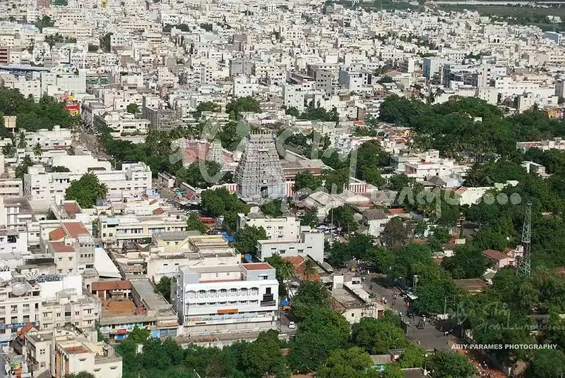
Overview
Karur stands at the meeting point of the Amaravathi, Kaveri, and Noyyal river systems in present-day Tamil Nadu. Its location helped make it an important inland settlement in the history of southern India. During the Sangam period, the town was known as Karuvur and was associated with Vanchi-Karuvoor, the capital of the Cheras. The precise location of that Chera capital remains debated: some historians identify it with modern Karur, while others connect it with Kodungallur in Kerala.
The archaeological record nevertheless establishes Karur’s importance during the Chera period. Excavations have produced pottery, bricks, mud toys, Roman amphorae, Russet Coated Ware, rings, and coins from different eras. Finds from the Amaravathi River bed include coins, seals, and rings bearing early Tamil Brahmi writing. Together, these discoveries point to a settlement involved in commerce, writing, craft production, and connections extending beyond the Tamil region.
Karur’s history continued through the rule of the Pandyas, Cholas, Vijayanagara authorities, Madurai Nayaks, the Kingdom of Mysore, and the British East India Company. Under British rule it became part of the Madras Presidency and developed an administrative role. Today, it is the headquarters of Karur district and a major centre for agriculture, textiles, coach building, and transport.
Etymology and Names
The modern name Karur is derived from Karuvur, the name associated with the ancient Chera settlement. In Tamil, karu can mean “embryo” and oor means “town” or “place,” giving the literal interpretation “embryo town.” This interpretation is also linked with Hindu mythology concerning Brahma, the creator god, and the settlement was earlier referred to as Brahmapuri.
The town has also been known in vernacular usage as Tiruvanilai and Pasupati. These names reflect the religious and cultural traditions attached to the place, particularly its temple associations. The form Vanchi-Karuvoor combines the name Vanchi with Karuvur and appears in discussions of the Chera capital.
Chola-period inscriptions provide an important historical form of the name. Inscriptions from the period of Kulothunga Chola I refer to the location as Vanchimanagarama Karuvur, meaning the Vanchi city of Karuvur. Such inscriptions connect the town’s political identity with both its older Chera associations and its place within the Chola world.
Geography and Location
Karur is located at 10.960° north and 78.075° east, at an average elevation of about 101 metres. It lies approximately 370 kilometres from Chennai, although the city is also described as being about 395 kilometres southwest of the state capital. The town occupies a plain landscape shaped by its proximity to the Amaravathi, Kaveri, and Noyyal rivers.
The surrounding soil is black and red, both suitable for common crops in the Cauvery region. Agriculture has therefore remained closely connected with Karur’s economy. Rice, cotton, sugarcane, and oilseeds are among the major crops, while coconut, banana, betel, and mango are important horticultural products.
Karur has a hot semi-arid climate. Temperatures generally range from a maximum of 39°C to a minimum of 17°C, with an average of approximately 28.7°C. May is the hottest month, with an average temperature of 31.5°C, while December is cooler, averaging 25.6°C.
Annual rainfall is relatively low, at about 590–600 millimetres compared with the Tamil Nadu average of 1,008 millimetres. The Southwest monsoon brings limited rain between June and August because Karur lies in the rain-shadow region of the Western Ghats. Most rainfall comes from the Northeast monsoon in October and November. October is the wettest month, while March is the driest.
This combination of river access, fertile soils, and a position between inland settlements and coastal routes gave Karur a strong geographical basis for both agriculture and commerce.
Ancient History
Karur was part of Kongu Nadu, a historic region of ancient Tamilakam. It was one of the older inhabited towns in the region and became closely associated with the Cheras, one of the three major Tamil kingdoms of the Sangam period. The Sangam period is generally placed between the third century BCE and the third century CE.
The town’s Chera identity is preserved in literary and epigraphic traditions. The Tamil epic Silappathikaram describes the Chera king Senguttuvan as ruling from Karuvur. The text also connects the Chera court with the religious and political world of the wider Tamil region. A Vishnu temple at Thiruvithuvakkodu, associated with Karur, is linked with Kulasekaraazhvaar and is also presumed to be mentioned in Silappathikaram as the place where Senguttuvan sought blessings before an expedition to northern India.
Archaeology adds a material dimension to these literary references. Excavations in Karur have yielded objects connected with daily life, architecture, trade, and craft production. Roman amphorae suggest the movement of goods in containers associated with Mediterranean commerce. Coins and pottery indicate exchange over time, while rings and other objects point to skilled metalworking and ornament production.
Karur may also have been an important centre for jewellery-making and gem setting. The range of excavated rings, beads, and related objects has led to this interpretation. The evidence does not establish every stage of the production process, but it shows that ornament manufacture and the handling of valuable materials formed part of the town’s ancient economic life.
In the second century CE, the Greek scholar Ptolemy referred to an inland trading centre called “Korevora.” This name is commonly connected with Karur. If that identification is correct, it places Karur within the network of inland markets known to geographers observing the commercial connections of South India.
Karur and the Roman Trade Route
Karur’s importance did not depend on a coastal harbour. Instead, it benefited from its location on an inland route linking the western and eastern sides of the Tamil region. The route extended from Muziris on the west coast to Arikamedu on the east coast. Karur’s position along this corridor allowed it to participate in the movement of goods between coastal ports and interior markets.
The finds associated with Roman commerce do not mean that Karur was a Roman settlement. They indicate contact and exchange. Amphorae, coins, and imported or imitation wares show that objects and commodities travelled through connected commercial systems. The town’s access to river valleys and routes across the interior made it a useful point for collection, redistribution, and craft activity.
The Amaravathi River bed has produced objects bearing early Tamil Brahmi writing. Tamil Brahmi inscriptions are especially important because they demonstrate the use of writing in the ancient Tamil region. Their presence on coins, seals, and rings connects literacy with commerce, identity, and ownership.
Archaeological evidence from Kodumanal, farther along the Noyyal River from Karur, records civilisation dating to the fourth century BCE. Although Kodumanal is a separate site, its evidence helps place Karur within a wider landscape of early settlement, manufacturing, and exchange. The Noyyal corridor was therefore part of a broader network rather than an isolated local zone.
Historical Timeline
Chera and Sangam Period
The Cheras ruled the region during the Sangam period, and Karur was known as Karuvur. It might have served as part of the Chera capital at Vanchi-Karuvoor. The exact location of Vanchi remains disputed, but the literary, archaeological, and geographical evidence demonstrates the region’s importance.
Trade, craft production, and riverine access shaped the town’s role. Karur was connected to routes extending from the western coast to the eastern coast, and material finds show that it participated in long-distance exchange.
Pandya Influence
By the seventh century CE, the region had come under Pandya influence during the reign of Arikesari Maravarman. This marked a change in political control, but Karur’s location continued to give it importance.
The historical record for this period is less detailed than the archaeological record for the earlier Chera phase. Nevertheless, the change illustrates the wider political competition among the major South Indian dynasties. Control of inland settlements such as Karur brought access to agricultural resources, routes, and established centres of production.
Chola Rule
The Cholas conquered the region in the ninth century under Aditya I. Karur remained directly under Imperial Chola control until 1064 CE. Thereafter, the Kongu Cholas, probably functioning as Chola vassals or viceroys, ruled the region with a degree of autonomy.
Temple inscriptions are particularly valuable for reconstructing this phase. Inscriptions dating to the reign of Kulothunga Chola I identify the settlement as Vanchimanagarama Karuvur. The wording preserved the older connection with Vanchi while placing the town within the political and administrative culture of the Cholas.
The Chola period also strengthened the importance of temple institutions in the region. Temples were places of worship, but inscriptions associated with them can also preserve information about land, administration, titles, and settlement names. At Karur, such records help show how an ancient Chera-associated centre was incorporated into later Chola political geography.
Vijayanagara and Madurai Nayak Rule
After the Chola period, Karur came under the influence of the Vijayanagara Empire and later the Madurai Nayaks, who had earlier been connected to Vijayanagara as subordinate rulers. This period formed part of the political reorganisation of South India under powerful regional and imperial authorities.
The available historical record identifies the dynasties that controlled the region but does not provide a continuous narrative of Karur’s local administration during every phase. Its continuing existence as a settlement, temple centre, and route-connected town nevertheless formed the background for later political struggles.
Mysore and British Control
In the latter part of the seventeenth century, Karur came under the influence of the Kingdom of Mysore. During the later eighteenth century, it changed hands several times between Mysore and the British East India Company.
The British captured Karur for the third time in 1790. Its fort remained a British garrison until 1801, demonstrating the military value attached to the settlement during this period of conflict. The fort’s role was part of a wider contest for control over the interior routes of South India.
Under the British Raj, Karur was annexed to the Madras Presidency. It served as the headquarters of a sub-collector, giving it a defined administrative position within the colonial system. The Karur municipality was constituted in 1874.
Independence and State Reorganisation
After Indian Independence in 1947, Karur became part of Madras State, the predecessor of Tamil Nadu. The States Reorganisation Act of 1956 altered state boundaries, and the majority of the region remained within the reorganised Madras State. In 1969, Madras State was renamed Tamil Nadu.
Karur subsequently developed as the headquarters of Karur district. Its historic role as a route-connected settlement was complemented by new administrative, industrial, and transport functions.
Political Significance
Karur’s political importance began with its association with the Chera kingdom and the possible capital of Vanchi-Karuvoor. Whether or not modern Karur was the sole location of that capital, the town occupied a prominent position in Chera historical memory and literature.
Later dynasties valued the region for its location and established settlement networks. The Pandyas, Cholas, Vijayanagara authorities, Madurai Nayaks, Mysore rulers, and the British all exercised power over it at different times. Chola inscriptions are evidence of the town’s integration into a larger imperial system, while the fort and garrison demonstrate its strategic value in the eighteenth century.
In the present, Karur is the administrative headquarters of its district. The municipality was first constituted in 1874, became first-grade in 1969, selected-grade in 1983, and special-grade in 1988. Karur Municipal Corporation was established in October 2021. It is headed by a mayor elected by councillors representing 48 wards.
Religious and Cultural Importance
Karur’s religious landscape reflects its long association with the Chera and Chola worlds. The Pasupatheeswarar Siva temple is a major cultural landmark of the town. Its traditions contribute to Karur’s identity as a temple-centred settlement as well as an administrative and commercial city.
The Vishnu temple at Thiruvithuvakkodu is associated with Kulasekaraazhvaar, dated to the seventh or eighth century CE. The temple is also connected in tradition with the Silappathikaram account of Cheran Senguttuvan seeking blessings before a northern expedition.
Karuvurar, who was born in medieval Karur, is identified as one of the nine composers associated with Thiruvichaippa, the ninth Thirumurai. This literary and devotional connection adds another layer to the town’s cultural history.
Tamil is the principal language of Karur and the official language of the region. English is commonly used in educational institutions and offices in the service sector. Hindus form the majority of the urban population, with Muslim and Christian communities also present.
Economic Role
Agriculture remains important to Karur and its surrounding settlements. About 19 percent of the city’s total area is under agricultural land use. Rice, cotton, sugarcane, and oilseeds are major crops, while coconut, banana, betel, and mango are important horticultural products. Karur functions as a commercial centre for agricultural commodities brought from nearby towns and villages.
The city’s modern economy is dominated by the tertiary sector, which employs approximately 80 percent of the workforce. The primary sector accounts for about 17 percent and the secondary sector about 4 percent.
Textiles form a major industry. Karur has ginning and spinning mills, dyeing factories, weaving enterprises, and an integrated textile park. In 2005, the textile industry was reported to generate revenues of approximately ₹20 billion annually. The city is also associated with the production of high-density polyethylene monofilament yarn and related products, with around 2,000 units engaged in this activity.
Coach building is another important industry. Karur is a major hub for the manufacture of bus coaches, with a substantial share of coaches built locally. The presence of Karur Vysya Bank and Lakshmi Vilas Bank, both headquartered in Karur, further reflects the city’s commercial role.
Other major industrial connections include the Tamil Nadu Newsprint and Papers facility near Karur, described as one of India’s largest paper producers; a Bharat Petroleum pipeline from Kochi to Karur; and a wet-process cement plant operated by the Chettinad Group at nearby Puliyur.
Monuments and Architecture
The Pasupatheeswarar Siva temple is central to Karur’s religious and architectural identity. It represents the town’s continuing temple tradition and its connection with the older names Pasupati and Tiruvanilai.
Karur fort is associated with the military history of the late eighteenth century. After the British captured Karur in 1790, the fort remained a British garrison until 1801. The surviving historical account highlights its role rather than providing a full architectural description.
The Vishnu temple at Thiruvithuvakkodu, associated with Kulasekaraazhvaar and the Silappathikaram tradition, links Karur’s wider region with Vaishnava literary and devotional history.
Famous Personalities
Cheran Senguttuvan is the most prominent ruler associated with Karur in literary tradition. The Silappathikaram describes him as ruling from Karuvur and connects him with the Chera political world.
Karuvurar, born in medieval Karur, was one of the nine figures associated with the devotional composition Thiruvichaippa, part of the ninth Thirumurai.
Kulasekaraazhvaar, dated to the seventh or eighth century CE, is connected with the Vishnu temple at Thiruvithuvakkodu. His association places the region within the history of Tamil devotional literature.
Decline and Revival
Karur did not experience a single, clearly documented collapse. Instead, its political affiliations changed repeatedly while its underlying geographical and economic functions continued. The town’s Chera association was followed by Pandya and Chola control, then by Vijayanagara, Nayak, Mysore, and British authority.
Its role changed most visibly in the colonial period. The fort became a British garrison, and the town served as a sub-collector’s headquarters. Municipal government was established in 1874, giving Karur a new institutional identity.
After Independence, the town’s development continued through district administration, road and rail connections, agriculture, textiles, coach building, and related industries. The modern city is therefore not a simple survival of the ancient trading centre; it is a layered urban settlement in which old routes, temples, administrative structures, and newer industries coexist.
Modern City
Karur’s population within the pre-expansion municipal area was 70,980 in the 2011 Census. After the city limits expanded from 5.96 square kilometres to 52.26 square kilometres, the population including the new limits was estimated at 394,719 in 2023.
The 2011 Census recorded a literacy rate of 81.7 percent and a sex ratio of 1,032 females per 1,000 males. Scheduled Castes accounted for 12.1 percent of the population and Scheduled Tribes for 0.1 percent.
Karur is connected by national and state highways, including NH 44 and NH 67. Its bus stand lies near the centre of town, and state transport services connect it with other parts of Tamil Nadu and neighbouring states. Karur Junction is an important railway junction in the Salem division of the Southern Railway. It links the Erode–Tiruchirappalli line with the Salem–Karur line and has five active platforms.
The nearest airport is Tiruchirapalli International Airport, 78 kilometres away. Within the city, municipal infrastructure includes water supplied from the Kaveri through 58 overhead tanks, public markets, storm-water drains, street lighting, healthcare facilities, and educational institutions. Karur medical college was established in 2019.
The city’s historical identity remains visible in its temples, place names, archaeological record, and relationship with the rivers and trade routes that shaped its past.
Timeline
Chera and Sangam Period
Karur, known as Karuvur, becomes associated with the Chera capital Vanchi-Karuvoor.
Ancient Trade
Karur participates in inland trade linking India’s western and eastern coasts.
Ptolemy’s Korevora
The Greek scholar Ptolemy mentions an inland trading centre identified with Karur.
Pandya Influence
The region comes under Pandya influence during the reign of Arikesari Maravarman.
Chola Conquest
Aditya I and the Cholas conquer the region.
Kongu Chola Administration
After direct Imperial Chola control, Kongu Chola rulers administer the region with autonomy.
Inscribed as Vanchimanagarama Karuvur
Chola-period temple inscriptions preserve Karur’s connection with Vanchi.
Mysore Influence
Karur comes under the influence of the Kingdom of Mysore.
British Capture
The British capture Karur for the third time.
End of the British Garrison
Karur fort ceases to serve as a British garrison.
Municipality Constituted
Karur municipality is formally established under British rule.
Independence
Karur becomes part of Madras State after Indian Independence.
Municipal Corporation
Karur Municipal Corporation is established.