Overview
The ancient city of Vijayapuri stood in the Krishna River valley before the waters of the Nagarjuna Sagar reservoir covered most of its remains. Today, Nagarjunakonda is an island in the reservoir, where excavated monuments, reconstructed ruins and a museum preserve the memory of a major Buddhist centre that once extended across the surrounding landscape.
The site rose to prominence in the early third century CE, when the Ikshvaku ruler Vashishthiputra Chamtamula established his capital at Vijayapuri. Under the Ikshvakus, royal families and lay patrons supported Buddhist monasteries, stupas and shrines, while the kings also built temples dedicated to Hindu deities. The resulting archaeological landscape was religiously diverse and closely connected to wider networks reaching Sri Lanka, Gandhara, Bengal, China and other parts of India.
Nagarjunakonda is also an important centre for the study of South Asian art. Its sculptures belong to the later phase of the Amaravati tradition, sometimes called the Later Andhra style. Coins, inscriptions, religious architecture, palace remains and objects displaying Roman and Scythian influence reveal a society linked to both regional kingdoms and long-distance cultural exchange.
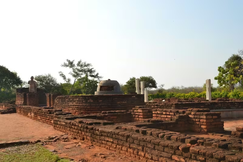
Its modern history is equally remarkable. Archaeologists excavated the site in stages between 1926 and 1960, racing to document and recover its remains before the construction of the Nagarjuna Sagar Dam. Many monuments were relocated to higher ground, while others were moved to the mainland. The island museum and reconstructed remains are therefore not simply ruins in their original setting; they are also a record of one of India's major archaeological rescue operations.
Etymology and Names
The name Nagarjunakonda is usually understood as “Nagarjuna Hill”: konda means “hill” in Telugu. It reflects the site's later association with Nagarjuna, the southern Indian master of Mahayana Buddhism traditionally dated to the second century CE. That association is not securely demonstrated by the archaeological record. The surviving early inscriptions instead identify the ancient city as Vijayapuri and connect it with Sriparvata, or Sri Parvata.
The ancient Ikshvaku inscriptions repeatedly associate their capital with Sriparvata. The name Nagarjunakonda appears to belong to a later period. This distinction matters because it separates the documented identity of the early royal capital from the traditions that grew around the hill in subsequent centuries.
Chinese Buddhist travellers also recorded names connected with the hill. Fa-Hien described a five-storey monastery and referred to it as Po-lo-yue. This has been interpreted either as a form of Parāvata, meaning “pigeon”, or Parvata, meaning “hill”. Hiuen-Tsang, who travelled through the Andhra region around 640 CE, referred to a place called Po-lo-mo-lo-ki-li, interpreted as “Mountain of the Black Bee”, associated with the Sanskrit name Bhramaragiri. Some scholars, however, have argued that this passage refers instead to Parimalagiri or Gandhagiri in Odisha. The identification therefore remains uncertain.
Nagarjunakonda should not be confused with the Nagarjuna or Nagarjuni caves near the Barabar Caves in Bihar. They are separate sites with different archaeological histories.
Geography and Location
Nagarjunakonda lies in the Krishna River valley in present-day Palnadu district of Andhra Pradesh. The ancient settlement occupied a hill and the surrounding valley, a landscape that gave the site both a distinctive physical setting and its later name. Its location placed it within the cultural zone of the lower and middle Krishna valley, not far from other major Buddhist centres of ancient Andhra.
The modern island is surrounded by the man-made Nagarjuna Sagar Lake. The original archaeological landscape was largely submerged when an irrigation dam was built across the nearby Krishna River. The monuments now visible on the island were excavated and relocated, or reconstructed from archaeological evidence, on higher ground.
Nagarjunakonda is about 160 kilometres west of Amaravati, another important historic Buddhist site. This geographical relationship helps place the site within the wider network of Andhra's Buddhist establishments. The surrounding region also includes the Nallamala Hills, Srisailam and the Nagarjunsagar-Srisailam wildlife landscape. Ethipothala Falls, where water descends about 22 metres into a blue lagoon, is another prominent natural feature in the wider area.
The island is not directly accessible from the state highway. Its main connection with the mainland is by ferry, while the nearest railway station is at Macherla, 29 kilometres away.
Ancient History
The earliest evidence recovered at Nagarjunakonda extends well beyond the age of the great Buddhist monasteries. Excavations conducted in the twentieth century produced material ranging from the Early Stone Age and Neolithic periods to the sixteenth century. The site therefore represents a long sequence of human occupation rather than a settlement created suddenly under one dynasty.
By the later Satavahana period, Buddhism had spread through the region. Coins associated with Gautamiputra Satakarni, Pulumavi and Yajna Satakarni have been found at the site. An inscription of Gautamiputra Vijaya Satakarni, dated to his sixth regnal year, provides further evidence for the presence of Buddhism.
The decisive transformation came after the decline of Satavahana power. In the first quarter of the third century CE, Vashishthiputra Chamtamula of the Ikshvaku dynasty established his capital at Vijayapuri. The kingdom's rulers are known through coins and inscriptions, which name four kings: Vashishthiputra Chamtamula, Mathariputra Virapurushadatta, Vashishthiputra Ehuvala Chamtamula and Vashishthiputra Rudrapurushadatta.
The Ikshvaku period saw both Buddhist and Hindu patronage. The kings built temples dedicated to Sarva-deva, Pushpabhadra, Karttikeya and Shiva. Their queens supported Buddhist monuments, as did Buddhist laywomen such as Bodhishri and Chandrashri. The princess Chamtisiri is particularly associated with the renovation of the great stupa. An inscription records that Camtisiri funded construction of the main stupa for ten consecutive years.
The Buddhist establishments were not limited to the royal household. Inscriptions preserve the names of many non-royal donors, showing that support came from a wider social base. At its height, more than thirty Buddhist viharas stood at Nagarjunakonda. These institutions made the city a major centre of religious learning in South India.
The later history of the Ikshvakus is less certain. The last surviving Ikshvaku inscription is dated to the eleventh regnal year of Rudrapurushadatta, around 309 CE. The dynasty's subsequent fate is unknown. The possibility that the Pallavas conquered their territory in the fourth century has been proposed, but it cannot be treated as certain.
Historical Timeline
Satavahana Connections
The Satavahana period established the wider political and cultural setting in which Nagarjunakonda developed. Coins of several later Satavahana rulers have been recovered, and the inscription of Gautamiputra Vijaya Satakarni shows that Buddhist activity was already present before the Ikshvaku capital was founded.
This evidence does not establish Nagarjunakonda as a Satavahana capital. It does, however, place the settlement within a region affected by Satavahana political power, coin circulation and Buddhist expansion.
The Ikshvaku Capital
The first quarter of the third century CE was the turning point in the site's history. Vashishthiputra Chamtamula made Vijayapuri his capital, and the city developed into a royal, religious and artistic centre.
The inscriptions of the Ikshvaku era are particularly valuable because they record royal patronage, family relationships, religious affiliations and donations. They also reveal the participation of women in the construction and maintenance of religious institutions. The combination of royal temples, Buddhist monasteries and donor inscriptions makes Vijayapuri an unusually rich site for studying the relationship between political authority and religious communities.
After the Ikshvakus
The disappearance of the Ikshvaku dynasty from the record was followed by a decline in the site's prominence. The Buddhist centre did not continue in its earlier form, although the wider Krishna valley remained religiously active. Brick shrines were built between the seventh and twelfth centuries, during the period when the region was controlled by the Chalukyas of Vengi.
Nagarjunakonda later became part of the Kakatiya kingdom and then the Delhi Sultanate. Its political importance returned in the fifteenth and sixteenth centuries, when a hill fortress stood at the site.
The Medieval Fortress
Contemporary texts and inscriptions describe a fortress on Nagarjunakonda hill. It was probably built by the Reddi rulers as a frontier fort protecting their principal stronghold at Kondaveedu. The fortress later came under Gajapati control. A 1491 CE inscription from the reign of the Gajapati king Purushottama names Sriratharaja Shingarayya Mahapatra as the official controlling it.
In 1515, the Vijayanagara ruler Krishnadevaraya stormed the fortress during his invasion of the Gajapati kingdom. The region subsequently passed through the authority of the Qutb Shahi dynasty and the Mughals before being granted as an agrahara to the pontiff of the Pushpagiri Math.
Political Significance
Vijayapuri's political importance began with its selection as the Ikshvaku capital. The capital was more than a royal residence: it was the setting in which political authority, religious patronage and public monument building were brought together. The city's inscriptions preserve the names of rulers, queens, donors and religious communities, allowing the political history of the period to be studied alongside its social and religious life.
The construction of Hindu temples by the Ikshvaku kings and Buddhist monuments by the royal family shows that political patronage was distributed across more than one religious tradition. The queens' role is especially visible in Buddhist donations, indicating that royal women were active participants in the public religious culture of the capital.
Centuries later, the hill's strategic value was expressed through its fortress. The medieval fort belonged to a different political world from the Ikshvaku capital, but its presence shows that the location retained military importance. Its position as a frontier defence for Kondaveedu and its involvement in the conflict between the Gajapatis and Vijayanagara demonstrate how the site was reinterpreted according to changing political needs.
Religious and Cultural Importance
Nagarjunakonda's Buddhist significance rests on the scale and diversity of its monastic remains. More than thirty monasteries once occupied the site. Inscriptions identify communities associated with the Bahushrutiya and Aparamahavinaseliya sub-schools of the Mahasanghika tradition, the Mahisasaka school and the Mahaviharavasin tradition of Sri Lanka.
The site was also cosmopolitan in a specific historical sense. Monasteries housed scholars and monks connected with Tamil regions, Orissa, Kalinga, Gandhara, Bengal, Ceylon and China. An inscription from Site No. 38 describes resident teachers and elders of the Vibhajyavada school as having gladdened the hearts of people from Kashmir, Gandhara, the Yavana lands, Vanavasa and Tambapamnidipa. These references show that Buddhist institutions at Vijayapuri participated in intellectual and monastic networks extending well beyond the Krishna valley.
A footprint at the Mahaviharavasin monastery was believed to reproduce the footprint of Gautama Buddha. The great stupa, known as the Mahachaitya, was also believed to contain sacred relics of the Buddha. These traditions contributed to the site's importance as a place of Buddhist memory and devotion.
Hindu religious activity was equally present in the archaeological record. Most identifiable Hindu shrines appear to have been Shaivite. One inscription names the deity Mahadeva Pushpabhadraswami, while stone images of Kartikeya were found at two other shrines. Another inscription refers to a Shiva temple. At least one temple, dated by inscription to 278 CE, has been identified as Vaishnavite on the basis of an eight-armed deity. A large sculpture of Devi adds another dimension to the site's religious landscape.
Economic and International Connections
Nagarjunakonda's material record indicates contact with the Roman world. Roman coins discovered at the site include an aureus of Tiberius, dated to 16–37 CE, and another associated with Faustina the Elder, dated to 141 CE. A coin of Antoninus Pius was also found. These objects suggest trade relations or monetary contact with the Roman world, although the coins alone do not define the precise mechanisms of exchange.
Roman influence is also proposed in the palace area's secular reliefs. One relief depicts Dionysus as a lightly bearded, semi-nude figure carrying a drinking horn, with a wine barrel beside him. Such secular imagery is unusual in the context of early Indian archaeological sites and gives the palace complex a distinctive place in the study of cross-cultural art.
Scythian influence is visible in reliefs of soldiers wearing distinctive caps and coats. An inscription further suggests that the Ikshvaku kings employed a garrison of Scythian guards. These details point to the movement of people, artistic forms and military personnel across political boundaries.
Monuments and Architecture
The Mahachaitya was the principal Buddhist stupa at Nagarjunakonda. It belonged to the class of uncased stupas: its brickwork was covered with plaster, and the monument was decorated with a large garland ornament. The original structure was renovated in the third century by the Ikshvaku princess Chamtisiri, who also sponsored the installation of stone ayaka pillars.
The stupa measured approximately 32.3 metres in diameter and rose to about 18 metres. A circumambulatory path, four metres wide, surrounded the monument. The medhi, or raised terrace, was about 1.5 metres high, while the rectangular ayaka platforms measured approximately 6.7 by 1.5 metres. The outer railing, if one existed, may have been made of wood, with its uprights set over a brick plinth.
The reliefs associated with Nagarjunakonda are closely related to those of the final phase of the Amaravati Stupa. They date broadly to the second quarter of the third century, slightly earlier than the major Ikshvaku developments at Nagarjunakonda. They are lively and expressive, but scholars have noted a decline from the mature Amaravati phase: compositions are less complex, figures display more mannerisms and the surfaces are flatter.
The palace area is particularly valuable because secular reliefs from such an early date are rare. Alongside scenes and figures connected with elite life, the complex preserves evidence of cultural contact with the Roman world.
The modern museum contains sculptures, friezes, coins, jewellery, tools and other archaeological material. Some large replicas of excavated monuments were constructed on the island so that visitors could understand the original architectural setting even after the ancient site disappeared beneath the reservoir.
Inscriptions and Languages
The Nagarjunakonda inscriptions date approximately from 210 to 325 CE and are associated with the development of Buddhist institutions and the rule of the Ikshvakus. They are written in Brahmi script and use Monumental Prakrit, Sanskrit and Epigraphical Hybrid Sanskrit.
These inscriptions are among the earliest substantial South Indian Sanskrit inscriptions, probably dating from the late third to early fourth centuries CE. Their language reflects the interaction between established regional inscriptional practices and the increasing prestige of Sanskrit in political and religious records.
The spread of Sanskrit epigraphy in the south may have been connected with the influence of the Western Satraps, who promoted Sanskrit inscriptions and maintained close relationships with southern rulers. One Nagarjunakonda memorial pillar records a marital connection between the Western Kshatrapas and the Ikshvakus. Virapurushadatta is also said to have married Rudradhara-bhattarika, described as the daughter of the ruler of Ujjain, possibly the Western Kshatrapa king Rudrasena II. The identification remains interpretive, but the inscription indicates the importance of wider political alliances.
Archaeological Research and Submergence
Modern archaeological attention began in 1926, when a local schoolteacher, Suraparaju Venkataramaih, noticed an ancient pillar and reported it to the Madras Presidency government. Shri Sarasvati, a Telugu-language assistant attached to the Archaeological Superintendent for Epigraphy of Madras, subsequently visited the site and recognised its potential.
The first discoveries were made by the French archaeologist Gabriel Jouveau-Dubreuil. Systematic excavations followed under English archaeologists led by A. H. Longhurst between 1927 and 1931. These campaigns uncovered Buddhist stupas, chaityas, sculptures and other structures.
T. N. Ramachandran directed another excavation in 1938, revealing further monuments. The most urgent phase began in 1954, when the proposed Nagarjuna Sagar Dam threatened to submerge the ancient landscape. A large salvage excavation under R. Subrahmanyam continued from 1954 to 1960. It recovered remains dating from the Early Stone Age to the sixteenth century.
The dam was constructed across the Krishna River between 1955 and 1967. In 1960, the reservoir submerged the original site. Archaeologists excavated and relocated almost all the recoverable remains. Some monuments were transferred to the top of Nagarjuna Hill, while others were moved to the mainland east of the flooded area. A museum was established on the hill in 1966, and approximately fourteen large replicas of excavated structures were created.
Nagarjunakonda therefore represents both an ancient historical landscape and a twentieth-century archaeological intervention. The island preserves the results of a major effort to document, rescue and reinterpret a site that could no longer remain in its original setting.
Modern Nagarjunakonda
The modern island is centred on its museum and reconstructed archaeological remains. The collections include Buddhist relics and sculptures, friezes, coins, jewellery and tools from Paleolithic and Neolithic contexts. A small tooth and an earring believed to belong to Gautama Buddha are among the objects associated with the museum, while the Mahachaitya is traditionally believed to contain sacred Buddhist relics.
A partly ruined monolithic Buddha image is one of the museum's principal attractions. The site also preserves a fourteenth-century fort and medieval temples, placing later political and religious history alongside the earlier Buddhist remains.
Nagarjunakonda is mainly reached by ferry from the mainland. The wider area offers views of the valley near the dam, while Ethipothala Falls and the Srisailam wildlife region add natural attractions. The nearby Nagarjunsagar-Srisailam Tiger Reserve provides habitat for diverse reptiles, birds and animals. Srisailam, on the Krishna River in the Nallamala Hills, is also a major historical and religious centre, including a Shiva temple counted among the twelve sacred Jyotirlingas.
The island's present form is a reminder that heritage sites can survive through relocation as well as preservation in place. The ancient city of Vijayapuri no longer stands in its original valley, but its inscriptions, sculptures, architectural plans and reconstructed monuments continue to reveal the complexity of early Andhra society.