Overview
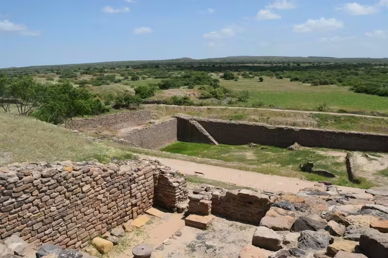
On Khadir Bet, an island-like elevation in the Great Rann of Kutch, the remains of Dholavira preserve the plan of a large Harappan city shaped by water scarcity. The settlement stood between two seasonal streams, the Mansar to the north and the Manhar to the south. Its builders surrounded urban life with fortifications, divided the settlement into distinct zones, and created an extensive system for collecting and storing water.
Dholavira is also known locally as Kotada timba. The archaeological site takes its name from the modern village of Dholavira, located about one kilometre to the south. Occupation was once generally placed between about 2650 and 1450 BCE, with a gradual decline after around 2100 BCE. More recent research has proposed an earlier beginning, around 3500 BCE, and continuity until approximately 1800 BCE.
The city is among the largest known Harappan settlements and is the most prominent site of the Indus Valley Civilization in India. Excavations have revealed fortified urban divisions, stone architecture, reservoirs, wells, drains, craft objects, burial structures, seals, pottery, and a large public signboard in the still-undeciphered Indus script. These remains make Dholavira essential to the study of early cities, long-distance exchange, writing, and hydraulic engineering.
Etymology and Names
The archaeological site is named after the modern village of Dholavira. In local usage, it is also called Kotada timba. The name therefore connects the ancient settlement with the landscape in which it survives rather than with a securely recorded ancient name.
Dholavira entered formal archaeological attention in the twentieth century. A resident of Dholavira village, Shambhudan Gadhvi, identified the location in the early 1960s and attempted to bring it to the attention of government authorities. The Archaeological Survey of India officially identified the site in 1967 or 1968, under J. P. Joshi.
Geography and Location
Dholavira lies on Khadir Bet in Kutch District, Gujarat, within the Kutch Desert Wildlife Sanctuary. The site is positioned on the Tropic of Cancer and is surrounded by the distinctive landscape of the Great Rann of Kutch. Its environment is arid, and the region can experience long periods without rainfall.
Two seasonal watercourses flank the settlement. The Mansar runs to the north and the Manhar to the south. Although neither is a permanent river, both shaped the city's development. The settlement's builders used channels, dams, wells, drains, and reservoirs to capture water from rainfall and from diverted flow.
This setting helps explain the importance of Dholavira's waterworks. Water management was not an isolated engineering project but a central part of the city's design. Reservoirs were placed around and within the built-up areas, while raised zones, including the citadel and bathing areas, occupied prominent positions in the urban plan.
The site is described as a quadrangular city covering 47 hectares, while the principal city layout is also given as approximately 22 hectares in extent. Within the general fortifications, the city covered about 48 hectares, and additional structure-bearing areas existed beyond the main walls. These varying measurements reflect different ways of defining the settlement and its built-up zones.
Ancient History
The earliest phases of Dholavira are now associated with a pre-Harappan Dholaviran culture. On the basis of recent radiocarbon dating and comparisons with Amri II-B pottery, the first two occupation stages have been placed around 3500–3200 BCE and 3200–2600 BCE. The mature urban history of the settlement developed after these early phases.
Ravindra Bisht, who directed the Dholavira excavations, identified seven stages of occupation. Earlier interpretations placed the main occupation from about 2650 BCE, followed by a slow decline after roughly 2100 BCE. The site was thought to have been briefly abandoned and then reoccupied until about 1450 BCE. Recent research instead suggests continuity until around 1800 BCE, in the early part of the Late Harappan period.
Earthquakes repeatedly affected Dholavira. One particularly severe earthquake is placed around 2600 BCE. Such events formed part of the settlement's environmental history and may have influenced rebuilding and changes in the city over time. The surviving remains represent several stages rather than one unaltered urban moment.
The city's material remains indicate varied activities. Excavations recovered animal bones, pottery, terracotta ornaments, bronze vessels, gold, silver, seals, beads, bangles, tools, stone weights, and architectural fragments. Together, these finds point to a settlement involved in craft production, administration, exchange, and the organization of urban life.
Historical Timeline
- c. 3500–3200 BCE: The earliest proposed phase of Dholavira's occupation.
- c. 3200–2600 BCE: A second pre-Harappan phase develops.
- c. 2600 BCE: A severe earthquake affects the settlement.
- c. 2650–2100 BCE: The major Harappan urban phases traditionally assigned to Dholavira flourish.
- After c. 2100 BCE: The city begins a gradual decline.
- c. 2100–1800 BCE: Recent research places continued occupation into the early Late Harappan period.
- 1990–2005: The Archaeological Survey of India conducts thirteen field excavations.
- 27 July 2021: Dholavira is inscribed as a UNESCO World Heritage Site under the name Dholavira: a Harappan City.
Urban Planning and Architecture
Dholavira was laid out according to a pre-existing geometrical plan. This distinguishes it from the description of Harappa and Mohenjo-daro, where brick dominates the surviving architecture. At Dholavira, the buildings visible today are constructed largely of stone.
The city was organized into three principal divisions: the citadel, the middle town, and the lower town. The acropolis and middle town each possessed defensive works, gateways, streets, wells, built-up areas, and large open spaces. The citadel occupied much of the southwestern zone and was the most heavily fortified and complex part of the settlement.
A fortified structure known as the castle was defended by double ramparts. Beside it stood an area called the bailey, associated with important officials. The city also had a town square and a raised area identified as the citadel. These arrangements suggest deliberate distinctions between residential, administrative, defensive, and public spaces.
The fortifications did not mark the full extent of settlement. Structure-bearing areas lay outside the principal walls but remained integral to the urban complex. Another settlement was also identified beyond the walls. Dholavira was therefore not simply a compact walled enclosure; it was a wider settlement system with differentiated zones.
Water Management
Dholavira's reservoirs are among its defining features. The inhabitants constructed a system of channels and storage spaces entirely in stone, creating one of the earliest large-scale urban water-conservation systems known. The arrangement responded directly to the desert conditions of Kutch, where rainfall could fail for several years.
At least sixteen reservoirs of varying sizes were created during the third stage of occupation. Some used the natural slope within the settlement, which drops approximately 13 metres from northeast to northwest. Others were excavated into the living rock. Three large reservoirs have been exposed, and further discoveries have expanded understanding of the system.
Two substantial reservoirs were identified east and south of the castle, the latter near an area called the Annexe. Reservoirs were cut vertically through stone and could reach about seven metres in depth and 79 metres in length. They skirted the city, while the citadel and bathing area stood on raised ground near the centre.
The waterworks included a large well with a stone-cut trough. This trough connected with a drain intended to carry water toward a storage tank. A bathing tank had steps descending inward. In October 2014, excavation began on a rectangular stepwell measuring approximately 73.4 metres in length, 29.3 metres in width, and 10 metres in depth. Its recorded dimensions made it three times larger than the Great Bath of Mohenjo-daro.
These installations demonstrate that Dholavira's urban planning treated water as a public and civic resource. Reservoirs, channels, drains, and wells were integrated into the layout rather than added as isolated features.
Trade, Crafts, and Material Culture
Archaeologists regard Dholavira as an important centre of exchange linking settlements in south Gujarat, Sindh, Punjab, and Western Asia. A possible coastal route is suggested between Lothal and Dholavira on one side and Sutkagan Dor on the Makran coast on the other. The exact organization of this route remains a matter of interpretation, but Dholavira's location placed it within wider networks of movement and exchange.
The range of finds reflects the city's connections and specialized production. Excavations recovered painted black-on-red pottery, large black-slipped jars with pointed bases, goblets, dishes on stands, perforated jars, terracotta tumblers, and pottery with painted motifs. Stone weights in different measures suggest systems of weighing and exchange.
Other objects include bronze vessels, a giant bronze hammer, a large chisel, a bronze hand mirror, copper celts and bangles, shell bangles, beads, rings, gold wire, gold ear studs, and gold globules with holes. Terracotta seals, stone seals, faience objects, grinding stones, mortars, and architectural members made from ballast stone were also found.
Some Stage III seals show animals without accompanying writing. These may represent an early convention in Indus seal-making. Seals could have served commercial or administrative purposes, although the undeciphered script prevents a complete understanding of their use.
The Dholavira Signboard and Indus Script
The Dholavira signboard is among the site's most remarkable discoveries. It was found in a side room of the northern gateway. The Harappans arranged pieces of gypsum to form ten large symbols or letters on a wooden board. When the board fell face-down, its wooden support eventually decayed, but the arrangement of the signs remained.
The board measured about three metres in length, and each symbol was approximately 37 centimetres high. The scale and public placement of the inscription distinguish it from the smaller signs commonly found on seals and objects. One sign appears four times. Because the inscription is large, public, and comparatively long, it is frequently discussed in debates over the nature of Indus writing and literacy.
The Indus script remains undeciphered. It appears to contain around 400 basic signs, with numerous variations. The signs may have represented words, syllables, or both. Writing generally ran from right to left. Inscriptions occur on stone seals and clay sealings, as well as on copper tablets, bronze tools, and small objects made from terracotta, stone, and faience.
Dholavira also produced a four-sign inscription in large letters on sandstone. It is regarded as the first inscription of this kind found at a Harappan site. These discoveries place Dholavira at the centre of discussions about writing, authority, public communication, and administration in the Indus Valley Civilization.
Funerary and Hemispherical Structures
Dholavira contains several unusual funerary or commemorative structures. A large circular structure consists of ten radial mud-brick walls arranged like the spokes of a wheel. It contained no skeleton or other human remains, leading to the interpretation that it may have been a grave or memorial.
Seven hemispherical constructions were identified, two of which were excavated in detail. They were elevated mud-brick structures built over large chambers cut into rock. One followed a spoked-wheel design; another had a circular form without spokes. Burial goods, including pottery, were found inside them.
Most of these structures contained no skeletons. One grave, however, contained a skeleton and a copper mirror. Finds from the hemispherical structures also included steatite beads strung on copper wire with hooks, a gold bangle, and gold and other beads.
The Archaeological Survey of India compared these forms with early Buddhist stupas and with designs mentioned in the Shatapatha Brahmana and Shulba Sutras. This is an interpretive comparison rather than evidence that Buddhist monuments existed at Dholavira. The structures belong to the much earlier Harappan setting and remain important for understanding the diversity of funerary practices at the site.
Archaeological Discoveries
Among the finds was a poorly preserved seated male figure made of stone. It has been compared with two high-quality stone sculptures from Harappa. A soft sandstone sculpture of a male figure, with the head and feet below the ankles truncated, was discovered in the passageway of the eastern gate.
Stone symbols resembling phalluses, rings, bangles, intaglio engravings, seals, animal representations, and tools broaden the picture of daily and ceremonial life. The objects do not, however, provide a fully readable account of the people who made them. Their language remains unknown, and the script that might have recorded names, institutions, or beliefs cannot yet be read securely.
The well-known bronze Dancing Girl should not be attributed to Dholavira. It was discovered at Mohenjo-daro. Its presence in general discussions of Harappan art reflects the shared cultural world of the Indus Civilization, but it is not an artifact from Dholavira.
Discovery, Excavation, and UNESCO Recognition
After Shambhudan Gadhvi brought attention to the location in the early 1960s, J. P. Joshi of the Archaeological Survey of India formally identified the site in 1967 or 1968. Excavation began under the ASI in 1989, with major fieldwork directed by Ravindra Bisht.
Thirteen field excavations were conducted between 1990 and 2005. These investigations revealed the city's planning, fortifications, reservoirs, streets, gateways, public spaces, craft remains, funerary structures, and inscriptions. The ASI stated that Dholavira had added new dimensions to the understanding of the Indus Valley Civilization.
Dholavira was inscribed on the UNESCO World Heritage List on 27 July 2021 as Dholavira: a Harappan City. Its recognition rests on the exceptional survival of a planned Harappan settlement and on the evidence it provides for ancient urban organization, architecture, water management, craft production, and writing.
Famous Personalities Associated with Dholavira
No ruler, monarch, or named Harappan resident is securely identified in the surviving evidence. The principal modern figures associated with the site's discovery and study are Shambhudan Gadhvi, who first drew official attention to the location, J. P. Joshi, who formally identified it for the Archaeological Survey of India, and Ravindra Bisht, who directed the major excavation programme.
Their work transformed Dholavira from a little-known ruin into one of the best-documented Harappan settlements in India.
Decline and Legacy
Dholavira declined gradually after around 2100 BCE according to the traditional chronology, although recent research emphasizes continuity into approximately 1800 BCE. Earlier interpretations proposed a brief abandonment followed by reoccupation until around 1450 BCE. The changing dates reflect ongoing archaeological reassessment rather than a settled single explanation.
The site also experienced repeated earthquakes, including a severe event around 2600 BCE. Environmental stress, changing settlement patterns, and the wider transformation of the Harappan world form the context for Dholavira's later history, but the surviving evidence does not establish one definitive cause for its decline.
Its legacy lies in the clarity of its urban design. Dholavira shows how a Bronze Age city could combine fortifications, public spaces, social divisions, stone construction, long-distance exchange, and complex water storage. It also preserves one of the most imposing examples of Indus writing in a public setting.
Modern Status
Dholavira remains an archaeological site in Gujarat's Kutch Desert Wildlife Sanctuary. The ruins are associated with the modern village that gave the site its name and are preserved within the distinctive environment of Khadir Bet and the Great Rann of Kutch.
As a UNESCO World Heritage Site, Dholavira represents the Harappan tradition through a specifically regional form. Its architecture differs from the predominantly brick remains of Harappa and Mohenjo-daro, while its reservoirs demonstrate an especially strong adaptation to an arid landscape. The site is therefore valuable not only for its age but also for the distinct solutions its builders developed.